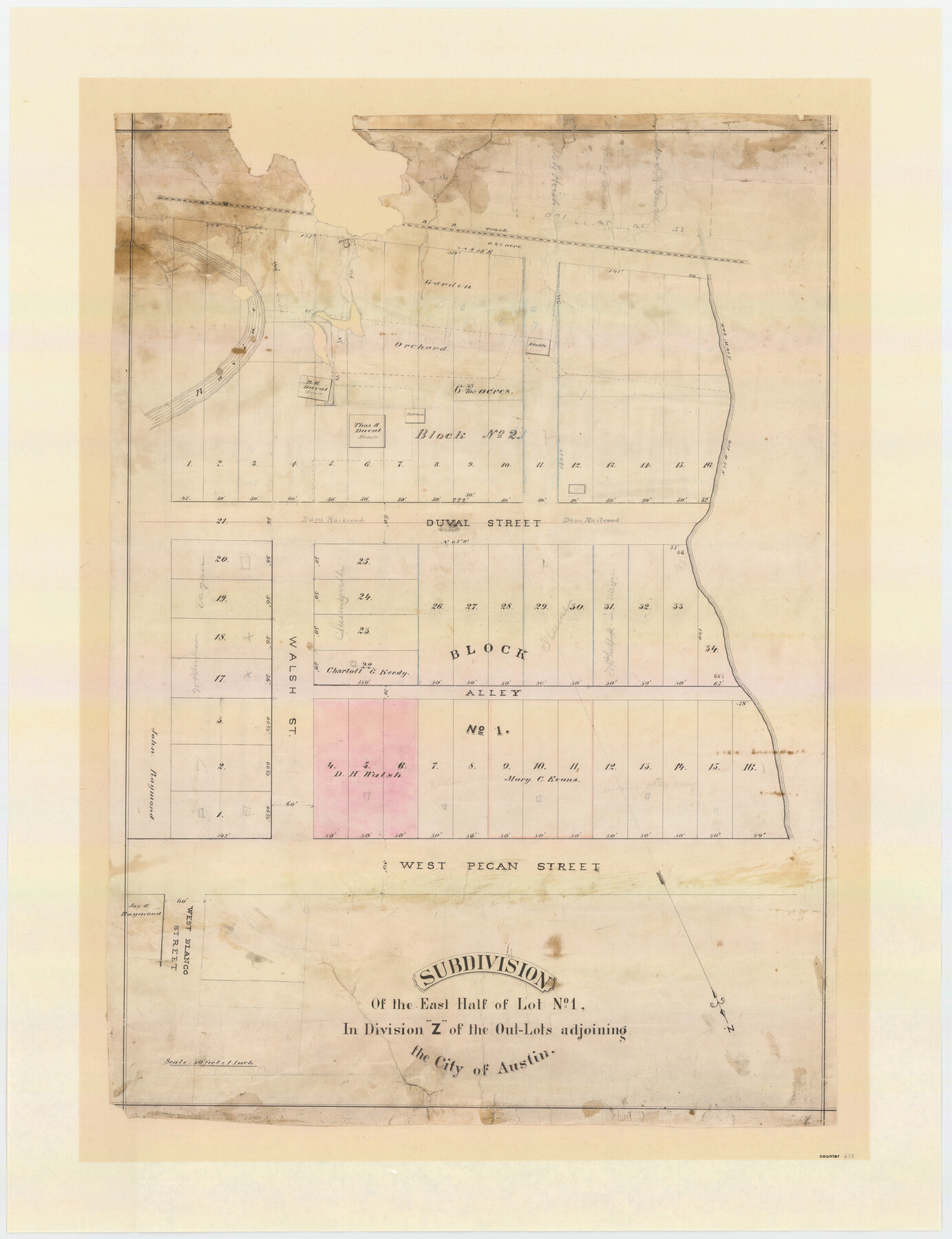
Subdivision of the East Half of Lot No. 1 in Division "Z" of the Out-Lots adjoining the City of Austin
-
Map/Doc
648
-
Collection
Maddox Collection
-
Counties
Travis
-
Subjects
City
-
Height x Width
32.1 x 42.6 inches
81.5 x 108.2 cm
-
Comments
Adopted in 2008 by Martha A. Compton of Dallas, Texas. Formerly the reverse of counter 452. This plat map was separated when counter 452 was conserved.
Part of: Maddox Collection
[Surveying Sketch of Heirs of Wm Neil, J.J. Hall, Robert Sikes, et al in Hutchinson County, Texas]
![75778, [Surveying Sketch of Heirs of Wm Neil, J.J. Hall, Robert Sikes, et al in Hutchinson County, Texas], Maddox Collection](https://historictexasmaps.com/wmedia_w700/maps/75778-1.tif.jpg)
Print $20.00
- Digital $50.00
[Surveying Sketch of Heirs of Wm Neil, J.J. Hall, Robert Sikes, et al in Hutchinson County, Texas]
Size 15.6 x 20.5 inches
Map/Doc 75778
Floyd County, Texas

Print $20.00
- Digital $50.00
Floyd County, Texas
1889
Size 24.8 x 19.2 inches
Map/Doc 626
[Office Sketch Showing George Tenille Grant, Brazoria County, Texas]
![75831, [Office Sketch Showing George Tenille Grant, Brazoria County, Texas], Maddox Collection](https://historictexasmaps.com/wmedia_w700/maps/75831.tif.jpg)
Print $20.00
- Digital $50.00
[Office Sketch Showing George Tenille Grant, Brazoria County, Texas]
Size 38.1 x 28.7 inches
Map/Doc 75831
Map of Mason County, Texas

Print $20.00
- Digital $50.00
Map of Mason County, Texas
Size 26.0 x 19.2 inches
Map/Doc 404
[Surveying Sketch of H. & T. C. R.R. Co. surveys, et al, unknown county]
![75988, [Surveying Sketch of H. & T. C. R.R. Co. surveys, et al, unknown county], Maddox Collection](https://historictexasmaps.com/wmedia_w700/maps/75988.tif.jpg)
Print $20.00
- Digital $50.00
[Surveying Sketch of H. & T. C. R.R. Co. surveys, et al, unknown county]
Size 21.0 x 25.7 inches
Map/Doc 75988
[Sketch Showing Blocks in Hansford County, Texas]
![75818, [Sketch Showing Blocks in Hansford County, Texas], Maddox Collection](https://historictexasmaps.com/wmedia_w700/maps/75818.tif.jpg)
Print $20.00
- Digital $50.00
[Sketch Showing Blocks in Hansford County, Texas]
1890
Size 34.3 x 24.6 inches
Map/Doc 75818
[Sketch of Sullivan Property]
![75775, [Sketch of Sullivan Property], Maddox Collection](https://historictexasmaps.com/wmedia_w700/maps/75775.tif.jpg)
Print $20.00
- Digital $50.00
[Sketch of Sullivan Property]
Size 14.3 x 22.7 inches
Map/Doc 75775
Mitchell County, Texas

Print $20.00
- Digital $50.00
Mitchell County, Texas
1870
Size 22.7 x 18.0 inches
Map/Doc 741
Tarrant County, Texas

Print $20.00
- Digital $50.00
Tarrant County, Texas
1870
Size 24.1 x 19.1 inches
Map/Doc 758
Baylor County, Texas

Print $20.00
- Digital $50.00
Baylor County, Texas
Size 21.7 x 18.9 inches
Map/Doc 525
Wichita County, Texas

Print $20.00
- Digital $50.00
Wichita County, Texas
1890
Size 26.9 x 32.1 inches
Map/Doc 679
Ward County, Texas

Print $20.00
- Digital $50.00
Ward County, Texas
1888
Size 20.2 x 25.5 inches
Map/Doc 657
You may also like
Winkler County Sketch File 18

Print $8.00
- Digital $50.00
Winkler County Sketch File 18
1999
Size 11.2 x 8.7 inches
Map/Doc 40517
Webb County Working Sketch 84

Print $20.00
- Digital $50.00
Webb County Working Sketch 84
1979
Size 27.0 x 24.3 inches
Map/Doc 72451
Blanco County Working Sketch 12

Print $3.00
- Digital $50.00
Blanco County Working Sketch 12
1943
Size 11.9 x 10.9 inches
Map/Doc 67372
Wharton County

Print $40.00
- Digital $50.00
Wharton County
1894
Size 55.8 x 36.0 inches
Map/Doc 87352
Nueces County Rolled Sketch 123

Print $20.00
- Digital $50.00
Nueces County Rolled Sketch 123
1997
Size 18.2 x 24.9 inches
Map/Doc 7158
General Highway Map, Bastrop County, Texas

Print $20.00
General Highway Map, Bastrop County, Texas
1940
Size 18.6 x 25.2 inches
Map/Doc 79012
Trinity County Working Sketch 11

Print $20.00
- Digital $50.00
Trinity County Working Sketch 11
1949
Size 47.0 x 42.6 inches
Map/Doc 69460
Current Miscellaneous File 94

Print $3.00
- Digital $50.00
Current Miscellaneous File 94
1851
Size 11.2 x 17.1 inches
Map/Doc 74268
Comal County Sketch File 20

Print $6.00
- Digital $50.00
Comal County Sketch File 20
1857
Size 12.4 x 8.1 inches
Map/Doc 19039
Irion County Rolled Sketch 8

Print $20.00
- Digital $50.00
Irion County Rolled Sketch 8
Size 42.9 x 34.1 inches
Map/Doc 9251
Map of Goliad County Texas

Print $20.00
- Digital $50.00
Map of Goliad County Texas
1879
Size 19.2 x 21.3 inches
Map/Doc 4547
Nacogdoches County Sketch File 18

Print $4.00
- Digital $50.00
Nacogdoches County Sketch File 18
1846
Size 6.0 x 9.4 inches
Map/Doc 32268