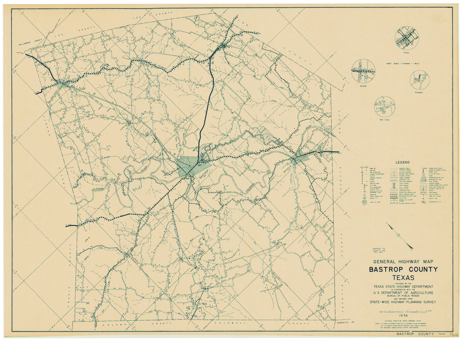
General Highway Map, Bastrop County, Texas
-
Map/Doc
79012
-
Collection
Texas State Library and Archives
-
Object Dates
1940 (Creation Date)
-
People and Organizations
Texas State Highway Department (Publisher)
-
Counties
Bastrop
-
Subjects
County
-
Height x Width
18.6 x 25.2 inches
47.2 x 64.0 cm
-
Comments
Prints available courtesy of the Texas State Library and Archives.
More info can be found here: TSLAC Map 04791
Part of: Texas State Library and Archives
General Highway Map, San Jacinto County, Texas

Print $20.00
General Highway Map, San Jacinto County, Texas
1961
Size 24.6 x 18.4 inches
Map/Doc 79646
Map of Texas, compiled from surveys on record in the General Land Office of the Republic

Print $20.00
Map of Texas, compiled from surveys on record in the General Land Office of the Republic
1839
Size 32.0 x 24.9 inches
Map/Doc 76198
General Highway Map. Detail of Cities and Towns in Travis County, Texas. City Map, Austin and vicinity, Travis County, Texas

Print $20.00
General Highway Map. Detail of Cities and Towns in Travis County, Texas. City Map, Austin and vicinity, Travis County, Texas
1961
Size 24.8 x 18.1 inches
Map/Doc 79686
General Highway Map, Armstrong County, Texas

Print $20.00
General Highway Map, Armstrong County, Texas
1961
Size 18.3 x 25.0 inches
Map/Doc 79354
General Highway Map, Kleberg County, Texas

Print $20.00
General Highway Map, Kleberg County, Texas
1940
Size 24.7 x 18.2 inches
Map/Doc 79164
General Highway Map, Castro County, Texas

Print $20.00
General Highway Map, Castro County, Texas
1940
Size 18.5 x 25.1 inches
Map/Doc 79043
General Highway Map, Childress County, Texas

Print $20.00
General Highway Map, Childress County, Texas
1940
Size 18.3 x 25.2 inches
Map/Doc 79046
Map of Central Texas Oil Fields

Print $20.00
Map of Central Texas Oil Fields
1918
Size 27.1 x 21.5 inches
Map/Doc 76295
General Highway Map, Floyd County, Texas

Print $20.00
General Highway Map, Floyd County, Texas
1961
Size 24.6 x 18.1 inches
Map/Doc 79467
Rand McNally Main Highway Map of Texas

Print $20.00
Rand McNally Main Highway Map of Texas
1923
Size 27.7 x 40.3 inches
Map/Doc 76260
General Highway Map, La Salle County, Texas

Print $20.00
General Highway Map, La Salle County, Texas
1961
Size 18.2 x 24.8 inches
Map/Doc 79565
Mapa de los Estados Unidos de Méjico, Segun lo organizado y definido por las varias actas del Congreso de dicha Republica: y construido por las mejores autoridades

Print $20.00
Mapa de los Estados Unidos de Méjico, Segun lo organizado y definido por las varias actas del Congreso de dicha Republica: y construido por las mejores autoridades
1846
Size 30.8 x 42.4 inches
Map/Doc 79727
You may also like
St. Louis Southwestern Railway of Texas

Print $20.00
- Digital $50.00
St. Louis Southwestern Railway of Texas
1906
Size 21.2 x 30.0 inches
Map/Doc 64447
Harris County Sketch File 9

Print $4.00
- Digital $50.00
Harris County Sketch File 9
1861
Size 6.7 x 7.3 inches
Map/Doc 25340
Map of Abilene

Print $20.00
- Digital $50.00
Map of Abilene
1885
Size 24.6 x 27.4 inches
Map/Doc 3042
Hutchinson County Rolled Sketch 42

Print $40.00
- Digital $50.00
Hutchinson County Rolled Sketch 42
1993
Size 38.5 x 49.9 inches
Map/Doc 6309
Crockett County Sketch File 60

Print $22.00
- Digital $50.00
Crockett County Sketch File 60
1925
Size 11.4 x 8.7 inches
Map/Doc 19837
Upshur County Working Sketch 17

Print $40.00
- Digital $50.00
Upshur County Working Sketch 17
1997
Size 48.4 x 37.1 inches
Map/Doc 69575
Beaumont, Texas

Print $20.00
- Digital $50.00
Beaumont, Texas
1930
Size 10.3 x 32.7 inches
Map/Doc 96428
Gaines County Rolled Sketch 29

Print $20.00
- Digital $50.00
Gaines County Rolled Sketch 29
1990
Size 14.7 x 20.5 inches
Map/Doc 5942
San Patricio County Working Sketch 21

Print $20.00
- Digital $50.00
San Patricio County Working Sketch 21
1981
Size 19.7 x 14.5 inches
Map/Doc 63783
Jack County Sketch File 35

Print $20.00
- Digital $50.00
Jack County Sketch File 35
1958
Size 23.9 x 35.6 inches
Map/Doc 11833
Harris County Boundary File 39 (18)

Print $4.00
- Digital $50.00
Harris County Boundary File 39 (18)
Size 12.7 x 7.9 inches
Map/Doc 54359
A sketch of surveys made on the coast east of Bolivar Point

Print $20.00
- Digital $50.00
A sketch of surveys made on the coast east of Bolivar Point
1841
Size 9.1 x 22.0 inches
Map/Doc 22