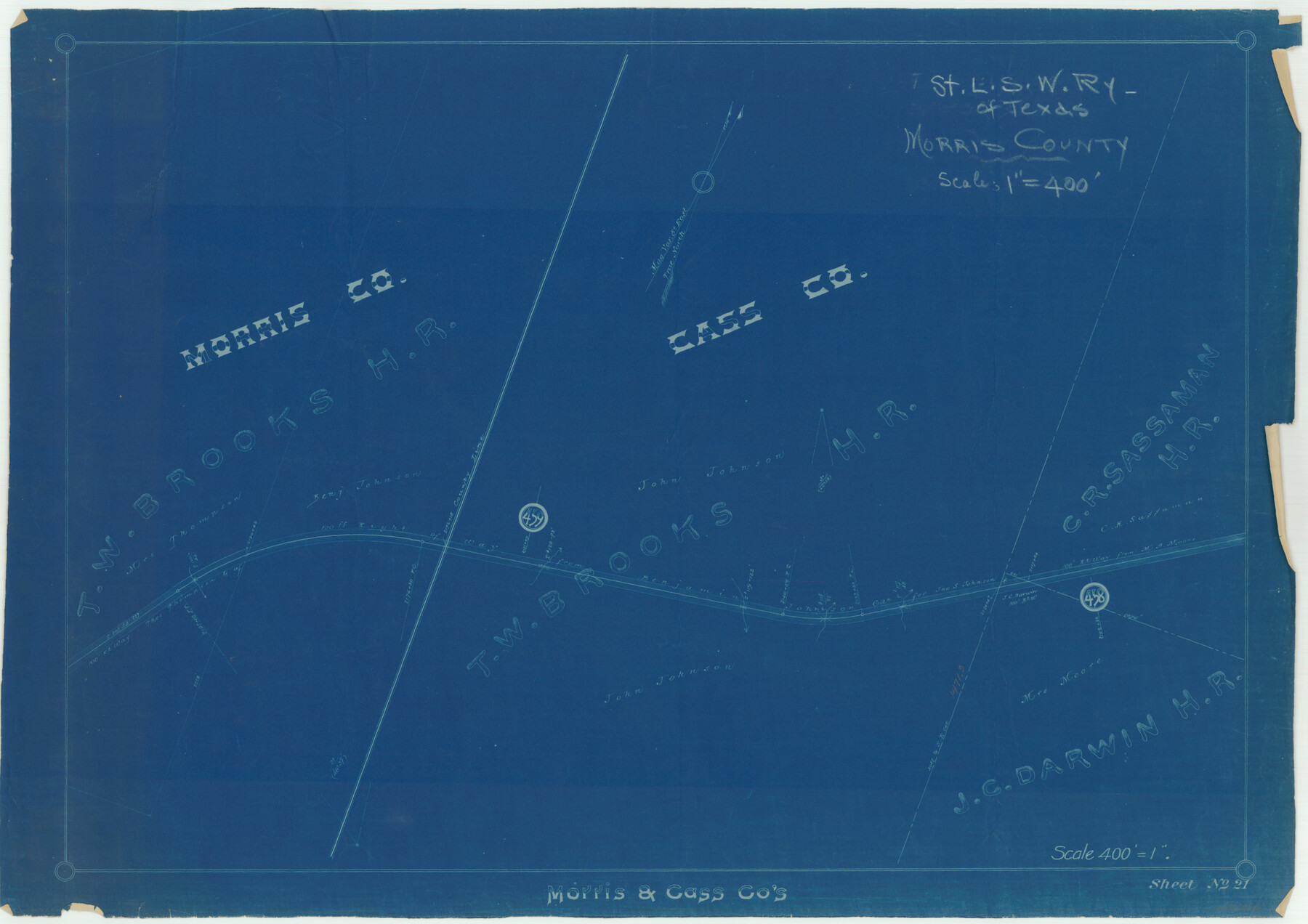
St. Louis Southwestern Railway of Texas
Z-2-121
-
Map/Doc
64447
-
Collection
General Map Collection
-
Object Dates
1906 (Creation Date)
-
Counties
Morris Cass
-
Subjects
Railroads
-
Height x Width
21.2 x 30.0 inches
53.8 x 76.2 cm
-
Medium
blueprint/diazo
-
Scale
1"=400'
-
Comments
Cotton Belt, See counter nos. 64448 through 64452 for other sheets.
-
Features
SLS
Part of: General Map Collection
Rockwall County Sketch File 8

Print $4.00
Rockwall County Sketch File 8
Size 7.1 x 10.6 inches
Map/Doc 35429
Denton County Sketch File 9

Print $6.00
- Digital $50.00
Denton County Sketch File 9
1856
Size 8.6 x 13.3 inches
Map/Doc 20705
Garza County Rolled Sketch 16

Print $20.00
- Digital $50.00
Garza County Rolled Sketch 16
Size 30.5 x 32.3 inches
Map/Doc 9048
Flight Mission No. CRK-5P, Frame 153, Refugio County

Print $20.00
- Digital $50.00
Flight Mission No. CRK-5P, Frame 153, Refugio County
1956
Size 18.4 x 22.3 inches
Map/Doc 86934
Tom Green County Sketch File 63A

Print $20.00
- Digital $50.00
Tom Green County Sketch File 63A
1891
Size 24.9 x 34.5 inches
Map/Doc 12446
Map of Runnels County

Print $20.00
- Digital $50.00
Map of Runnels County
1867
Size 27.3 x 19.3 inches
Map/Doc 4003
Flight Mission No. DAG-23K, Frame 16, Matagorda County

Print $20.00
- Digital $50.00
Flight Mission No. DAG-23K, Frame 16, Matagorda County
1953
Size 18.5 x 22.2 inches
Map/Doc 86478
Mills County Boundary File 6

Print $2.00
- Digital $50.00
Mills County Boundary File 6
Size 11.0 x 8.6 inches
Map/Doc 57311
Coleman County Sketch File 19

Print $4.00
- Digital $50.00
Coleman County Sketch File 19
Size 12.5 x 8.1 inches
Map/Doc 18692
Stonewall County

Print $20.00
- Digital $50.00
Stonewall County
1879
Size 22.7 x 19.1 inches
Map/Doc 4058
[Surveys along Davidson's Creek]
![243, [Surveys along Davidson's Creek], General Map Collection](https://historictexasmaps.com/wmedia_w700/maps/243.tif.jpg)
Print $2.00
- Digital $50.00
[Surveys along Davidson's Creek]
Size 5.3 x 4.7 inches
Map/Doc 243
Ector County Working Sketch 25

Print $20.00
- Digital $50.00
Ector County Working Sketch 25
1961
Size 29.6 x 34.2 inches
Map/Doc 68868
You may also like
![90260, [League 271], Twichell Survey Records](https://historictexasmaps.com/wmedia_w700/maps/90260-1.tif.jpg)
Spanish North America

Print $20.00
- Digital $50.00
Spanish North America
1814
Size 21.9 x 29.8 inches
Map/Doc 89224
Crockett County Sketch File 95

Print $24.00
- Digital $50.00
Crockett County Sketch File 95
Size 11.2 x 8.9 inches
Map/Doc 19952
General Highway Map, Upshur County, Texas

Print $20.00
General Highway Map, Upshur County, Texas
1961
Size 18.1 x 24.8 inches
Map/Doc 79692
Coleman County Sketch File 10

Print $20.00
- Digital $50.00
Coleman County Sketch File 10
1848
Size 28.0 x 13.2 inches
Map/Doc 11119
Madison County

Print $20.00
- Digital $50.00
Madison County
1871
Size 14.0 x 19.6 inches
Map/Doc 3833
Gaines County Sketch File 2M

Print $20.00
- Digital $50.00
Gaines County Sketch File 2M
1902
Size 20.8 x 29.4 inches
Map/Doc 11522

McCulloch County Working Sketch 6

Print $20.00
- Digital $50.00
McCulloch County Working Sketch 6
1961
Size 15.2 x 23.9 inches
Map/Doc 70681
Roundabout The Nation's Capital with Descriptive Notes

Roundabout The Nation's Capital with Descriptive Notes
1956
Size 35.0 x 29.8 inches
Map/Doc 92362
Crane County Working Sketch 5

Print $40.00
- Digital $50.00
Crane County Working Sketch 5
1928
Size 34.5 x 49.0 inches
Map/Doc 68282
Map of Runnels County

Print $20.00
- Digital $50.00
Map of Runnels County
1898
Size 43.2 x 36.9 inches
Map/Doc 16803