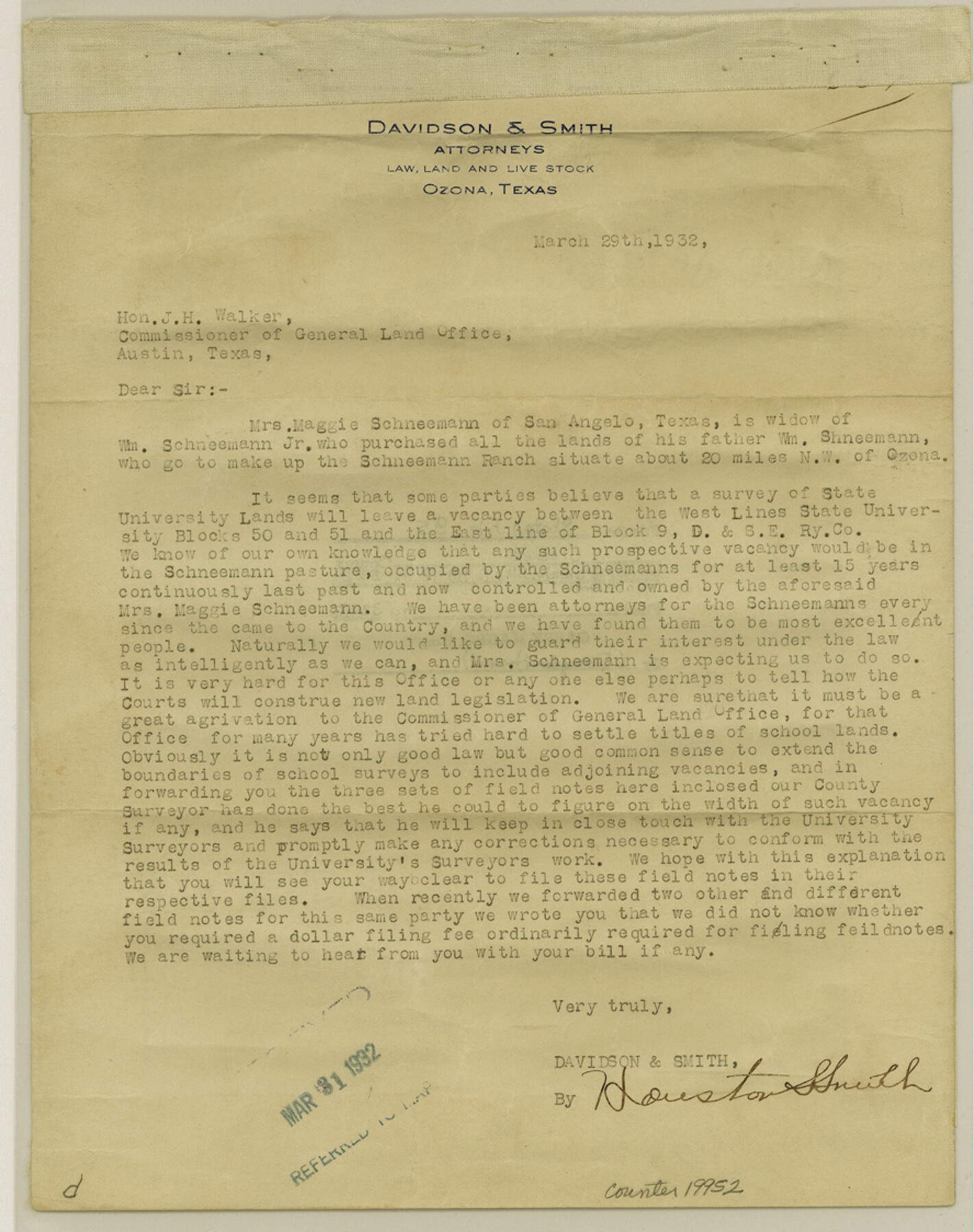
Crockett County Sketch File 95
[Various correspondence and sketches concerning Blocks Q, BB, YZ, WX and Block 29, University Lands]
-
Map/Doc
19952
-
Collection
General Map Collection
-
Object Dates
1936 (File Date)
-
People and Organizations
Frank F. Friend (Surveyor/Engineer)
-
Counties
Crockett
-
Subjects
Surveying Sketch File
-
Height x Width
11.2 x 8.9 inches
28.4 x 22.6 cm
-
Medium
multi-page, multi-format
-
Features
Live Oak Creek
Grierson Springs
Fort Lancaster
Part of: General Map Collection
Brazos River, Darrington-Ramsey Farms Project

Print $20.00
- Digital $50.00
Brazos River, Darrington-Ramsey Farms Project
1930
Size 37.5 x 26.8 inches
Map/Doc 69677
Controlled Mosaic by Jack Amman Photogrammetric Engineers, Inc - Sheet 14

Print $20.00
- Digital $50.00
Controlled Mosaic by Jack Amman Photogrammetric Engineers, Inc - Sheet 14
1954
Size 20.0 x 24.0 inches
Map/Doc 83458
Irion County Boundary File 4a

Print $40.00
- Digital $50.00
Irion County Boundary File 4a
Size 8.6 x 38.7 inches
Map/Doc 55361
Jefferson County Rolled Sketch 4

Print $40.00
- Digital $50.00
Jefferson County Rolled Sketch 4
Size 36.7 x 65.3 inches
Map/Doc 9269
Wood County Working Sketch 7

Print $20.00
- Digital $50.00
Wood County Working Sketch 7
1942
Size 41.0 x 37.7 inches
Map/Doc 62007
Hutchinson Co.

Print $20.00
- Digital $50.00
Hutchinson Co.
1891
Size 27.5 x 21.3 inches
Map/Doc 4986
Fisher County Sketch File A and A1

Print $8.00
- Digital $50.00
Fisher County Sketch File A and A1
1901
Size 14.4 x 9.2 inches
Map/Doc 22583
[Bastrop District]
![83005, [Bastrop District], General Map Collection](https://historictexasmaps.com/wmedia_w700/maps/83005.tif.jpg)
Print $40.00
- Digital $50.00
[Bastrop District]
1895
Size 37.4 x 51.9 inches
Map/Doc 83005
Montgomery County Working Sketch 38

Print $20.00
- Digital $50.00
Montgomery County Working Sketch 38
1954
Size 23.6 x 28.5 inches
Map/Doc 71145
Uvalde County Working Sketch 50

Print $40.00
- Digital $50.00
Uvalde County Working Sketch 50
1980
Size 55.7 x 36.6 inches
Map/Doc 72120
Right of Way and Track Map, Galveston, Harrisburg & San Antonio Ry. operated by the T. & N. O. R.R. Co., Victoria Division, Rosenberg to Beeville

Print $40.00
- Digital $50.00
Right of Way and Track Map, Galveston, Harrisburg & San Antonio Ry. operated by the T. & N. O. R.R. Co., Victoria Division, Rosenberg to Beeville
Size 24.3 x 55.8 inches
Map/Doc 76162
Jeff Davis County Working Sketch Graphic Index - central part

Print $40.00
- Digital $50.00
Jeff Davis County Working Sketch Graphic Index - central part
1982
Size 55.7 x 42.6 inches
Map/Doc 76593
You may also like
Maps of Gulf Intracoastal Waterway, Texas - Sabine River to the Rio Grande and connecting waterways including ship channels

Print $20.00
- Digital $50.00
Maps of Gulf Intracoastal Waterway, Texas - Sabine River to the Rio Grande and connecting waterways including ship channels
1966
Size 14.4 x 22.2 inches
Map/Doc 61943

[Surveys in Power and Hewetson's Colony along the San Antonio and Guadalupe Rivers]
![23, [Surveys in Power and Hewetson's Colony along the San Antonio and Guadalupe Rivers], General Map Collection](https://historictexasmaps.com/wmedia_w700/maps/23.tif.jpg)
Print $20.00
- Digital $50.00
[Surveys in Power and Hewetson's Colony along the San Antonio and Guadalupe Rivers]
1837
Size 14.9 x 16.5 inches
Map/Doc 23
Flight Mission No. BRA-8M, Frame 71, Jefferson County

Print $20.00
- Digital $50.00
Flight Mission No. BRA-8M, Frame 71, Jefferson County
1953
Size 18.7 x 22.3 inches
Map/Doc 85591
Liberty County Working Sketch 47

Print $20.00
- Digital $50.00
Liberty County Working Sketch 47
1954
Size 28.3 x 24.6 inches
Map/Doc 70506
[Sketch showing B. S. & F. survey number 9, section 9]
![91711, [Sketch showing B. S. & F. survey number 9, section 9], Twichell Survey Records](https://historictexasmaps.com/wmedia_w700/maps/91711-1.tif.jpg)
Print $2.00
- Digital $50.00
[Sketch showing B. S. & F. survey number 9, section 9]
Size 8.7 x 8.1 inches
Map/Doc 91711
Kent County Sketch File 7

Print $20.00
- Digital $50.00
Kent County Sketch File 7
1902
Size 21.7 x 37.6 inches
Map/Doc 10514
Fisher County Sketch File 2

Print $2.00
- Digital $50.00
Fisher County Sketch File 2
1885
Size 12.4 x 7.5 inches
Map/Doc 22548
Orange County Rolled Sketch 31

Print $40.00
- Digital $50.00
Orange County Rolled Sketch 31
1926
Size 88.7 x 35.2 inches
Map/Doc 9651
San Jacinto County Working Sketch 15

Print $20.00
- Digital $50.00
San Jacinto County Working Sketch 15
1935
Size 32.0 x 36.5 inches
Map/Doc 63728

Travis County Sketch File 11

Print $4.00
- Digital $50.00
Travis County Sketch File 11
1872
Size 11.4 x 8.8 inches
Map/Doc 38300