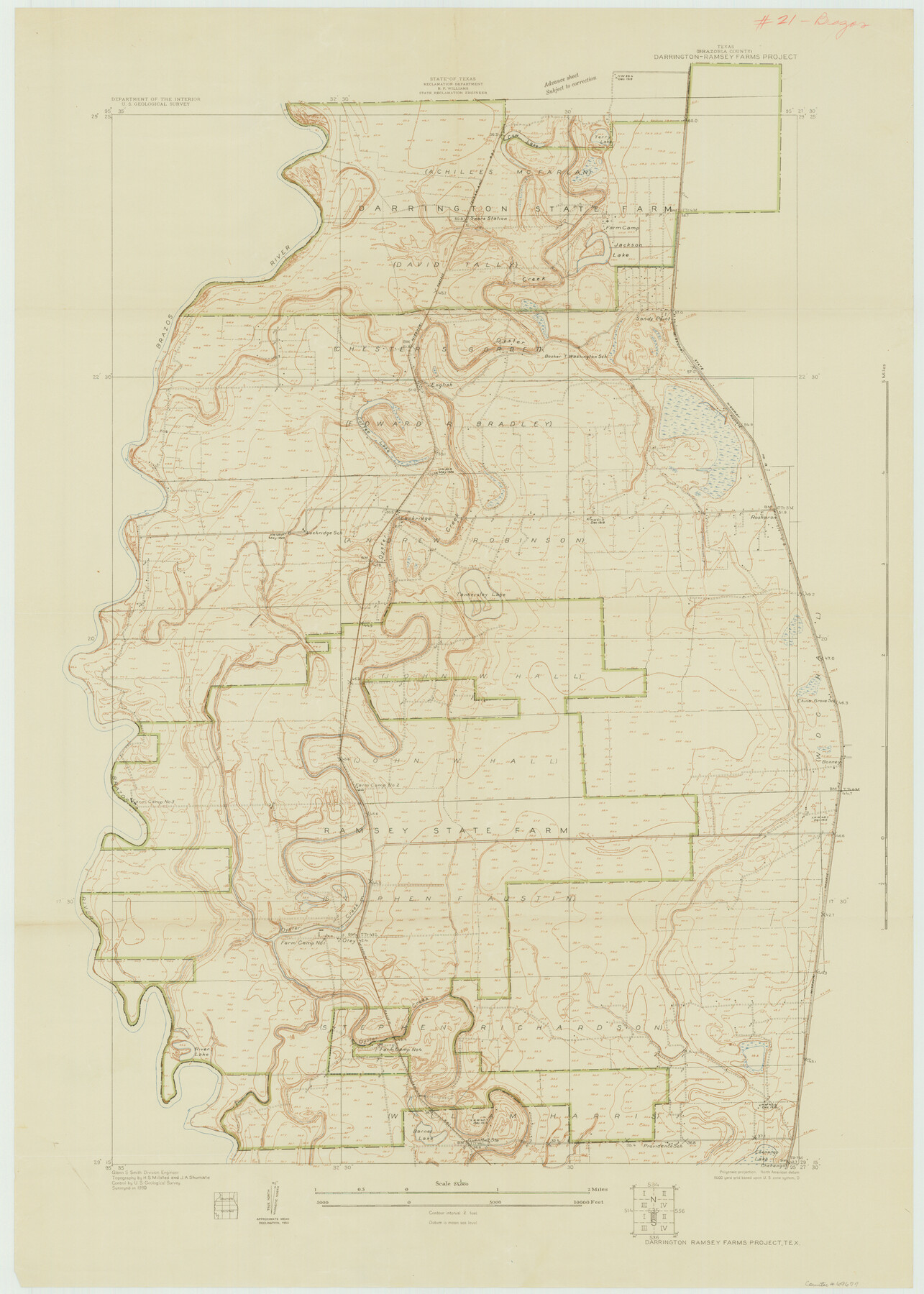
Brazos River, Darrington-Ramsey Farms Project
-
Map/Doc
69677
-
Collection
General Map Collection
-
Object Dates
1930 (Creation Date)
-
People and Organizations
Texas State Reclamation Department (Publisher)
Glenn S. Smith (Surveyor/Engineer)
H.S. Milsted (Surveyor/Engineer)
J.A. Shumate (Surveyor/Engineer)
-
Counties
Brazoria
-
Subjects
Prison Farms River Surveys Topographic
-
Height x Width
37.5 x 26.8 inches
95.3 x 68.1 cm
Part of: General Map Collection
Flight Mission No. BRE-1P, Frame 107, Nueces County

Print $20.00
- Digital $50.00
Flight Mission No. BRE-1P, Frame 107, Nueces County
1956
Size 18.5 x 22.6 inches
Map/Doc 86678
Maps of Gulf Intracoastal Waterway, Texas - Sabine River to the Rio Grande and connecting waterways including ship channels

Print $20.00
- Digital $50.00
Maps of Gulf Intracoastal Waterway, Texas - Sabine River to the Rio Grande and connecting waterways including ship channels
1966
Size 14.5 x 22.2 inches
Map/Doc 61974
Briscoe County Working Sketch 12

Print $40.00
- Digital $50.00
Briscoe County Working Sketch 12
1984
Size 43.6 x 60.3 inches
Map/Doc 67815

Wilbarger County Boundary File 1a

Print $32.00
- Digital $50.00
Wilbarger County Boundary File 1a
Size 14.2 x 8.7 inches
Map/Doc 59936
Shelby County Sketch File 3

Print $4.00
- Digital $50.00
Shelby County Sketch File 3
1849
Size 11.9 x 7.9 inches
Map/Doc 36595
Flight Mission No. DQO-8K, Frame 12, Galveston County

Print $20.00
- Digital $50.00
Flight Mission No. DQO-8K, Frame 12, Galveston County
1952
Size 18.7 x 22.4 inches
Map/Doc 85135
Hemphill County Rolled Sketch 13

Print $20.00
- Digital $50.00
Hemphill County Rolled Sketch 13
1905
Size 20.7 x 28.9 inches
Map/Doc 6193
Leon County Rolled Sketch 23

Print $20.00
- Digital $50.00
Leon County Rolled Sketch 23
1981
Size 33.6 x 40.7 inches
Map/Doc 6609
Flight Mission No. CLL-1N, Frame 21, Willacy County

Print $20.00
- Digital $50.00
Flight Mission No. CLL-1N, Frame 21, Willacy County
1954
Size 18.7 x 22.3 inches
Map/Doc 87008
Bexar County Sketch File 36a

Print $10.00
- Digital $50.00
Bexar County Sketch File 36a
1873
Size 11.3 x 8.8 inches
Map/Doc 14507
Coke County Working Sketch 14

Print $40.00
- Digital $50.00
Coke County Working Sketch 14
1948
Size 50.3 x 43.1 inches
Map/Doc 68051
You may also like
Gregg County Working Sketch 24

Print $20.00
- Digital $50.00
Gregg County Working Sketch 24
1985
Size 26.6 x 16.3 inches
Map/Doc 63291
Johnson County Working Sketch 5

Print $20.00
- Digital $50.00
Johnson County Working Sketch 5
1950
Size 25.8 x 22.3 inches
Map/Doc 66618
Anderson County Sketch File 24

Print $60.00
- Digital $50.00
Anderson County Sketch File 24
1942
Size 13.2 x 18.2 inches
Map/Doc 10803
Robertson County Working Sketch 17

Print $20.00
- Digital $50.00
Robertson County Working Sketch 17
1991
Size 16.8 x 22.9 inches
Map/Doc 63590
Hidalgo County Rolled Sketch 7

Print $20.00
- Digital $50.00
Hidalgo County Rolled Sketch 7
1905
Size 20.4 x 26.1 inches
Map/Doc 6208
Matagorda County Rolled Sketch PHL1

Print $20.00
- Digital $50.00
Matagorda County Rolled Sketch PHL1
Size 36.5 x 39.1 inches
Map/Doc 9477
Bell County Rolled Sketch 2

Print $20.00
- Digital $50.00
Bell County Rolled Sketch 2
1954
Size 27.0 x 28.0 inches
Map/Doc 5133
Wichita County Working Sketch 19

Print $20.00
- Digital $50.00
Wichita County Working Sketch 19
1949
Size 18.1 x 30.9 inches
Map/Doc 72529
Map of Andrews County

Print $40.00
- Digital $50.00
Map of Andrews County
1900
Size 40.8 x 52.9 inches
Map/Doc 4780
Taylor County Working Sketch 4b

Print $20.00
- Digital $50.00
Taylor County Working Sketch 4b
1944
Size 17.0 x 14.2 inches
Map/Doc 69614
La Salle County Boundary File 57

Print $26.00
- Digital $50.00
La Salle County Boundary File 57
Size 9.2 x 4.7 inches
Map/Doc 56242
Railroad Track Map, T&PRRCo., Culberson County, Texas

Print $4.00
- Digital $50.00
Railroad Track Map, T&PRRCo., Culberson County, Texas
1910
Size 11.7 x 18.6 inches
Map/Doc 62829