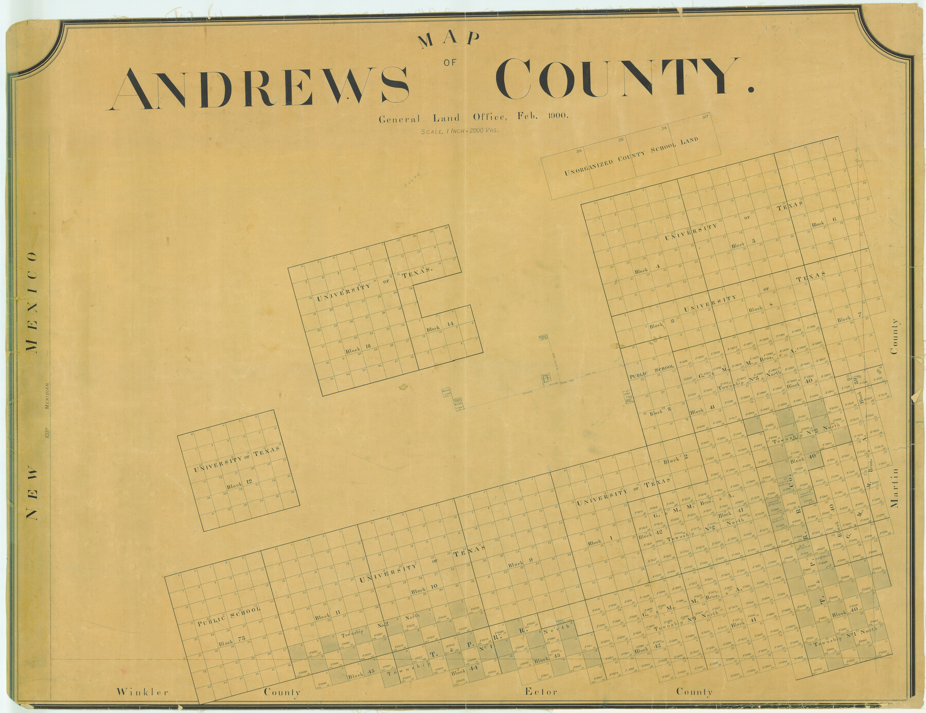
Map of Andrews County
-
Map/Doc
4780
-
Collection
General Map Collection
-
Object Dates
1900 (Creation Date)
-
People and Organizations
Texas General Land Office (Publisher)
-
Counties
Andrews
-
Subjects
County
-
Height x Width
40.8 x 52.9 inches
103.6 x 134.4 cm
-
Comments
Possibly unfinished map or very little surveyed at this point.
Help Save Texas History - Adopt Me!
Part of: General Map Collection
Travis County Working Sketch 48

Print $40.00
- Digital $50.00
Travis County Working Sketch 48
1981
Size 53.7 x 40.3 inches
Map/Doc 69432
Hudspeth County Working Sketch 38

Print $20.00
- Digital $50.00
Hudspeth County Working Sketch 38
1978
Size 31.8 x 36.9 inches
Map/Doc 66323

Mills County Working Sketch 5

Print $3.00
- Digital $50.00
Mills County Working Sketch 5
1914
Size 13.1 x 10.8 inches
Map/Doc 71035
San Patricio County

Print $20.00
- Digital $50.00
San Patricio County
1939
Size 31.6 x 41.6 inches
Map/Doc 77416
Lee County Working Sketch 5

Print $20.00
- Digital $50.00
Lee County Working Sketch 5
1975
Size 38.5 x 36.2 inches
Map/Doc 70384
Kimble County Rolled Sketch 39

Print $20.00
- Digital $50.00
Kimble County Rolled Sketch 39
1986
Size 27.0 x 27.5 inches
Map/Doc 6529
Jefferson County Rolled Sketch 51

Print $20.00
- Digital $50.00
Jefferson County Rolled Sketch 51
1965
Size 39.1 x 38.0 inches
Map/Doc 9307
Edwards County Working Sketch 68

Print $20.00
- Digital $50.00
Edwards County Working Sketch 68
1957
Size 28.7 x 26.8 inches
Map/Doc 68944
[The S.K. Ry. of Texas, State Line to Pecos, Reeves Co., Texas]
![64160, [The S.K. Ry. of Texas, State Line to Pecos, Reeves Co., Texas], General Map Collection](https://historictexasmaps.com/wmedia_w700/maps/64160.tif.jpg)
Print $40.00
- Digital $50.00
[The S.K. Ry. of Texas, State Line to Pecos, Reeves Co., Texas]
1910
Size 19.5 x 119.7 inches
Map/Doc 64160
Aransas County Rolled Sketch 19B

Print $20.00
- Digital $50.00
Aransas County Rolled Sketch 19B
1979
Size 25.7 x 18.7 inches
Map/Doc 76077
Harris County Rolled Sketch 102

Print $20.00
- Digital $50.00
Harris County Rolled Sketch 102
2009
Size 24.8 x 36.5 inches
Map/Doc 89585
You may also like
Mapa de los Estados Unidos Mejicanos arreglado a la distribucion que en diversos decretos ha hecho del territorio el Congreso General Mejicano

Print $20.00
- Digital $50.00
Mapa de los Estados Unidos Mejicanos arreglado a la distribucion que en diversos decretos ha hecho del territorio el Congreso General Mejicano
1837
Size 24.3 x 29.4 inches
Map/Doc 96515
Cameron County Rolled Sketch 16

Print $20.00
- Digital $50.00
Cameron County Rolled Sketch 16
Size 31.8 x 37.4 inches
Map/Doc 8569
Wharton County Sketch File 11

Print $4.00
- Digital $50.00
Wharton County Sketch File 11
1891
Size 9.1 x 12.3 inches
Map/Doc 39933
Map of the River Sabine from its mouth on the Gulf of Mexico in the Sea to Logan's Ferry in Latitude 31°58'24" North

Print $40.00
- Digital $50.00
Map of the River Sabine from its mouth on the Gulf of Mexico in the Sea to Logan's Ferry in Latitude 31°58'24" North
1842
Size 67.6 x 30.6 inches
Map/Doc 87152
Galveston County Working Sketch 22

Print $20.00
- Digital $50.00
Galveston County Working Sketch 22
1988
Size 27.4 x 38.3 inches
Map/Doc 69359
[Sketch showing Block AX, North part of Block G, Block S and part of Block D]
![92018, [Sketch showing Block AX, North part of Block G, Block S and part of Block D], Twichell Survey Records](https://historictexasmaps.com/wmedia_w700/maps/92018-1.tif.jpg)
Print $20.00
- Digital $50.00
[Sketch showing Block AX, North part of Block G, Block S and part of Block D]
Size 33.2 x 44.1 inches
Map/Doc 92018
Map B [showing surveys along river and in vicinity of Archer County School Land League 3]
![89752, Map B [showing surveys along river and in vicinity of Archer County School Land League 3], Twichell Survey Records](https://historictexasmaps.com/wmedia_w700/maps/89752-1.tif.jpg)
Print $20.00
- Digital $50.00
Map B [showing surveys along river and in vicinity of Archer County School Land League 3]
Size 42.7 x 38.0 inches
Map/Doc 89752
Sherman County Rolled Sketch 8

Print $20.00
- Digital $50.00
Sherman County Rolled Sketch 8
Size 25.3 x 26.2 inches
Map/Doc 7788

Randall County Sketch File 8

Print $20.00
- Digital $50.00
Randall County Sketch File 8
Size 18.1 x 23.1 inches
Map/Doc 12209
Mills County Sketch File 1

Print $8.00
- Digital $50.00
Mills County Sketch File 1
1853
Size 11.6 x 12.7 inches
Map/Doc 31641
G. T. Oliver's Subdivisions of the Motley and Foard County School Leagues situated in Bailey Co., Texas

Print $20.00
- Digital $50.00
G. T. Oliver's Subdivisions of the Motley and Foard County School Leagues situated in Bailey Co., Texas
1909
Size 24.5 x 37.3 inches
Map/Doc 90181