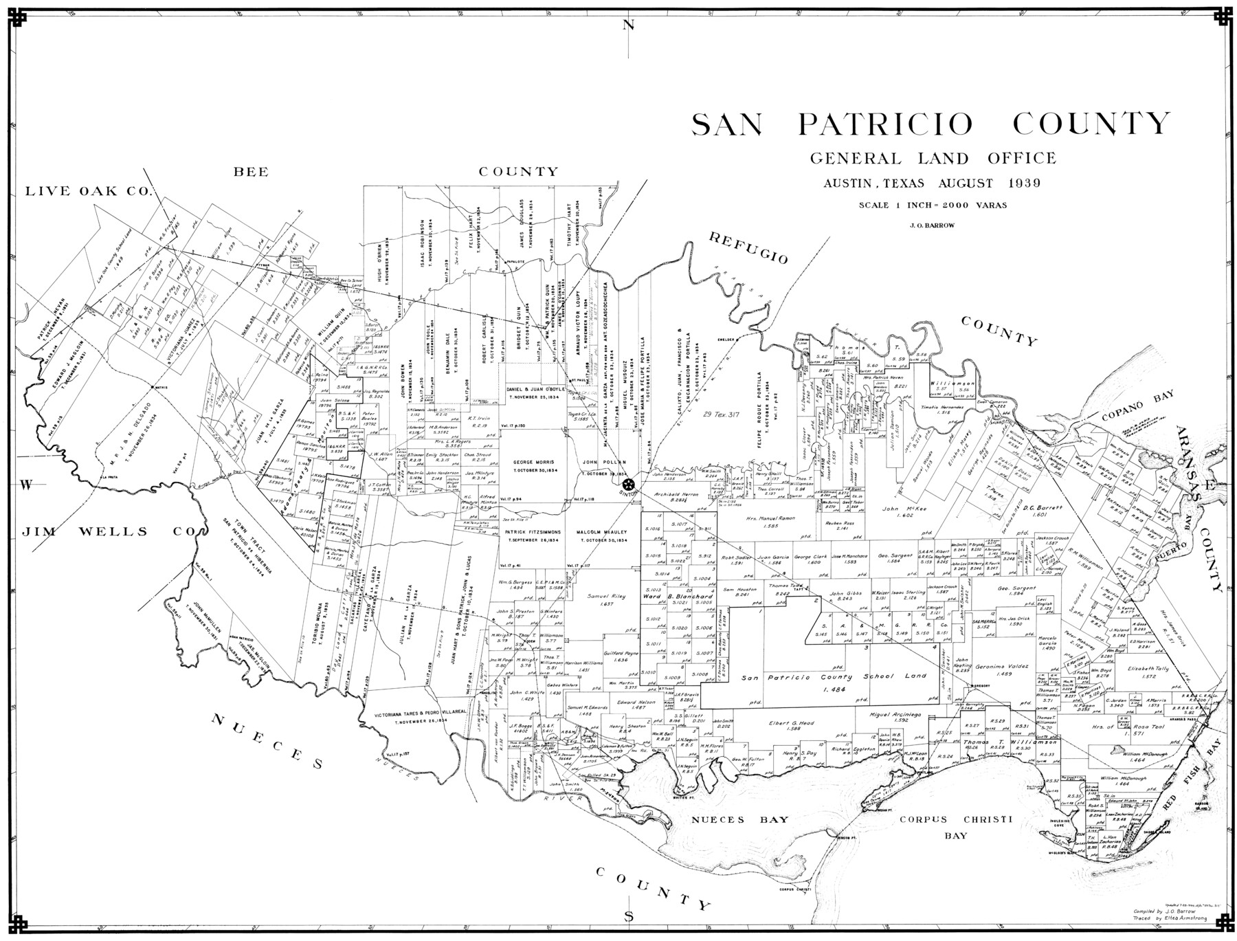
San Patricio County
-
Map/Doc
77416
-
Collection
General Map Collection
-
Object Dates
1939 (Creation Date)
-
People and Organizations
Eltea Armstrong (Draftsman)
J.O. Barrow (Compiler)
-
Counties
San Patricio
-
Subjects
County
-
Height x Width
31.6 x 41.6 inches
80.3 x 105.7 cm
Part of: General Map Collection
Presidio County Working Sketch 73

Print $20.00
- Digital $50.00
Presidio County Working Sketch 73
1962
Size 17.7 x 29.4 inches
Map/Doc 71750
Frio County Sketch File 1

Print $8.00
- Digital $50.00
Frio County Sketch File 1
1848
Size 8.6 x 7.7 inches
Map/Doc 23101
Levee Improvement Districts Width of Floodways - South Sulphur River

Print $6.00
- Digital $50.00
Levee Improvement Districts Width of Floodways - South Sulphur River
1918
Size 19.6 x 34.1 inches
Map/Doc 65175
Glasscock County Sketch File 21

Print $20.00
- Digital $50.00
Glasscock County Sketch File 21
1936
Size 23.1 x 20.3 inches
Map/Doc 11564
Limestone County Sketch File 8

Print $20.00
- Digital $50.00
Limestone County Sketch File 8
1869
Size 15.6 x 23.7 inches
Map/Doc 12002
Angelina County Sketch File 2

Print $2.00
- Digital $50.00
Angelina County Sketch File 2
Size 8.6 x 6.0 inches
Map/Doc 12921
Crosby County Rolled Sketch 1

Print $20.00
- Digital $50.00
Crosby County Rolled Sketch 1
1950
Size 25.3 x 21.1 inches
Map/Doc 5640
Kimble County Working Sketch 70

Print $20.00
- Digital $50.00
Kimble County Working Sketch 70
1965
Size 41.2 x 25.3 inches
Map/Doc 70138
Hopkins County Working Sketch 4

Print $20.00
- Digital $50.00
Hopkins County Working Sketch 4
1959
Size 23.3 x 30.9 inches
Map/Doc 66229
Schleicher County Rolled Sketch 7

Print $20.00
- Digital $50.00
Schleicher County Rolled Sketch 7
Size 32.5 x 37.9 inches
Map/Doc 9904
Lipscomb County Boundary File 14

Print $62.00
- Digital $50.00
Lipscomb County Boundary File 14
Size 13.3 x 8.8 inches
Map/Doc 56355
Anderson County Boundary File 4

Print $10.00
- Digital $50.00
Anderson County Boundary File 4
Size 8.9 x 7.4 inches
Map/Doc 49737
You may also like
Map of Bailey County, Texas

Print $20.00
- Digital $50.00
Map of Bailey County, Texas
1912
Size 15.8 x 19.8 inches
Map/Doc 90248

[Movements & Objectives of the 143rd & 144th Infantry on October 13, 1918, Appendix L]
![94124, [Movements & Objectives of the 143rd & 144th Infantry on October 13, 1918, Appendix L], Non-GLO Digital Images](https://historictexasmaps.com/wmedia_w700/maps/94124-1.tif.jpg)
Print $20.00
[Movements & Objectives of the 143rd & 144th Infantry on October 13, 1918, Appendix L]
1918
Size 16.1 x 16.8 inches
Map/Doc 94124
Flight Mission No. CUG-1P, Frame 69, Kleberg County

Print $20.00
- Digital $50.00
Flight Mission No. CUG-1P, Frame 69, Kleberg County
1956
Size 18.6 x 22.3 inches
Map/Doc 86134
Harris County Working Sketch 14

Print $20.00
- Digital $50.00
Harris County Working Sketch 14
Size 18.9 x 17.4 inches
Map/Doc 65906
Fort Bend County Sketch File 10

Print $20.00
- Digital $50.00
Fort Bend County Sketch File 10
Size 16.9 x 24.9 inches
Map/Doc 11501
San Saba County

Print $20.00
- Digital $50.00
San Saba County
1987
Size 46.3 x 42.5 inches
Map/Doc 73284
Map of section no. 5 of a survey of Padre Island made for the Office of the Attorney General of the State of Texas

Print $40.00
- Digital $50.00
Map of section no. 5 of a survey of Padre Island made for the Office of the Attorney General of the State of Texas
1941
Size 49.8 x 40.0 inches
Map/Doc 2261
South Montgomery County, Woodlands Chamber of Commerce Street Map

South Montgomery County, Woodlands Chamber of Commerce Street Map
Size 50.0 x 37.9 inches
Map/Doc 94363
[Sections 1-21, H. & G. N. Block 11]
![93116, [Sections 1-21, H. & G. N. Block 11], Twichell Survey Records](https://historictexasmaps.com/wmedia_w700/maps/93116-1.tif.jpg)
Print $20.00
- Digital $50.00
[Sections 1-21, H. & G. N. Block 11]
Size 31.3 x 42.8 inches
Map/Doc 93116
Pecos County Rolled Sketch 125

Print $20.00
- Digital $50.00
Pecos County Rolled Sketch 125
1948
Size 32.0 x 41.6 inches
Map/Doc 7266
Right of Way and Track Map, the Missouri, Kansas and Texas Ry. of Texas - Henrietta Division

Print $20.00
- Digital $50.00
Right of Way and Track Map, the Missouri, Kansas and Texas Ry. of Texas - Henrietta Division
1918
Size 11.8 x 26.8 inches
Map/Doc 64752