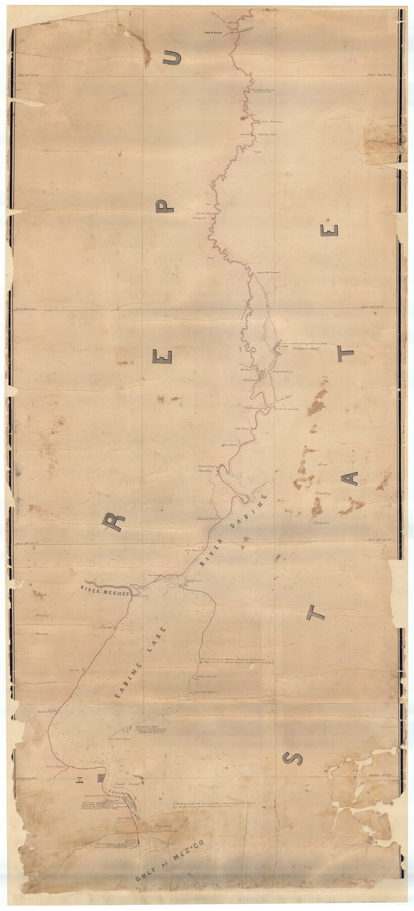
Map of the River Sabine from its mouth on the Gulf of Mexico in the Sea to Logan's Ferry in Latitude 31°58'24" North
K-3-55
-
Map/Doc
87152
-
Collection
General Map Collection
-
Object Dates
[1842 ca.] (Creation Date)
-
People and Organizations
Joint Boundary Commission (Author)
A.B. Gray (Draftsman)
P.J. Pillans (Surveyor/Engineer)
A.B. Gray (Surveyor/Engineer)
G.G. Meade (Surveyor/Engineer)
J.D. Graham (Surveyor/Engineer)
T.J. Lee (Surveyor/Engineer)
-
Subjects
River Surveys Texas Boundaries
-
Height x Width
67.6 x 30.6 inches
171.7 x 77.7 cm
-
Comments
Conservation funded in 2006 by Friends of the Texas General Land Office. Conserved in three pieces. See map 87150 for north part and 87151 for the center part. See map 1744 for the digitally combined image. Texas version of Joint (Boundary) Commission ma
-
URLs
https://medium.com/save-texas-history/map-of-the-river-sabine-e3da735c9925
Related maps
Map of the River Sabine from its mouth on the Gulf of Mexico in the Sea to Logan's Ferry in Latitude 31°58'24" North

Print $40.00
- Digital $50.00
Map of the River Sabine from its mouth on the Gulf of Mexico in the Sea to Logan's Ferry in Latitude 31°58'24" North
1842
Size 173.2 x 31.0 inches
Map/Doc 1744
Journal of the Joint Commission

Print $35.00
- Digital $50.00
Journal of the Joint Commission
1838
Size 9.3 x 6.1 inches
Map/Doc 65515
Map of the River Sabine from its mouth on the Gulf of Mexico in the Sea to Logan's Ferry in Latitude 31°58'24" North

Print $20.00
- Digital $50.00
Map of the River Sabine from its mouth on the Gulf of Mexico in the Sea to Logan's Ferry in Latitude 31°58'24" North
1842
Size 47.9 x 30.6 inches
Map/Doc 87150
Map of the River Sabine from its mouth on the Gulf of Mexico in the Sea to Logan's Ferry in Latitude 31°58'24" North

Print $40.00
- Digital $50.00
Map of the River Sabine from its mouth on the Gulf of Mexico in the Sea to Logan's Ferry in Latitude 31°58'24" North
1842
Size 60.5 x 30.6 inches
Map/Doc 87151
[Map of the River Sabine from its mouth on the Gulf of Mexico in the sea to Logan's Ferry in Latitude 31° 58' 24" North]
![94005, [Map of the River Sabine from its mouth on the Gulf of Mexico in the sea to Logan's Ferry in Latitude 31° 58' 24" North], General Map Collection](https://historictexasmaps.com/wmedia_w700/maps/94005.tif.jpg)
Print $20.00
- Digital $50.00
[Map of the River Sabine from its mouth on the Gulf of Mexico in the sea to Logan's Ferry in Latitude 31° 58' 24" North]
Size 31.5 x 31.3 inches
Map/Doc 94005
[Map of the River Sabine from its mouth on the Gulf of Mexico in the sea to Logan's Ferry in Latitude 31° 58' 24" North]
![94006, [Map of the River Sabine from its mouth on the Gulf of Mexico in the sea to Logan's Ferry in Latitude 31° 58' 24" North], General Map Collection](https://historictexasmaps.com/wmedia_w700/maps/94006.tif.jpg)
Print $20.00
- Digital $50.00
[Map of the River Sabine from its mouth on the Gulf of Mexico in the sea to Logan's Ferry in Latitude 31° 58' 24" North]
Size 37.7 x 31.6 inches
Map/Doc 94006
Part of: General Map Collection

Plan of the town of Austin

Print $20.00
- Digital $50.00
Plan of the town of Austin
Size 18.4 x 13.0 inches
Map/Doc 94117
Sketch of coast of Texas, Laguna Madre from Pt. of Rocks to Corpus Christi [and accompanying letter]
![72963, Sketch of coast of Texas, Laguna Madre from Pt. of Rocks to Corpus Christi [and accompanying letter], General Map Collection](https://historictexasmaps.com/wmedia_w700/maps/72963.tif.jpg)
Print $2.00
- Digital $50.00
Sketch of coast of Texas, Laguna Madre from Pt. of Rocks to Corpus Christi [and accompanying letter]
1882
Size 11.2 x 8.8 inches
Map/Doc 72963
Map of Runnels County

Print $20.00
- Digital $50.00
Map of Runnels County
1879
Size 25.9 x 18.5 inches
Map/Doc 4620

Dimmit County Working Sketch 23

Print $20.00
- Digital $50.00
Dimmit County Working Sketch 23
1954
Size 22.5 x 23.3 inches
Map/Doc 68684
Nolan County Working Sketch 6

Print $20.00
- Digital $50.00
Nolan County Working Sketch 6
1950
Size 27.2 x 26.0 inches
Map/Doc 71297
Location of the Southern Kansas Railway of Texas, Roberts County, Texas

Print $40.00
- Digital $50.00
Location of the Southern Kansas Railway of Texas, Roberts County, Texas
1887
Size 20.0 x 75.1 inches
Map/Doc 64037
Hardin County Sketch File 56a

Print $40.00
- Digital $50.00
Hardin County Sketch File 56a
Size 12.7 x 15.9 inches
Map/Doc 25226
Lavaca County Sketch File 21

Print $40.00
- Digital $50.00
Lavaca County Sketch File 21
1951
Size 60.6 x 39.1 inches
Map/Doc 10520
Travis County Sketch File 57

Print $8.00
- Digital $50.00
Travis County Sketch File 57
1947
Size 11.4 x 8.8 inches
Map/Doc 38402
Nueces County Rolled Sketch 109

Print $20.00
- Digital $50.00
Nueces County Rolled Sketch 109
1989
Size 18.8 x 25.0 inches
Map/Doc 7116
You may also like
Briscoe County Sketch File F

Print $40.00
- Digital $50.00
Briscoe County Sketch File F
1917
Size 20.9 x 19.3 inches
Map/Doc 76756
Orange County Working Sketch 12

Print $20.00
- Digital $50.00
Orange County Working Sketch 12
1922
Size 17.2 x 12.7 inches
Map/Doc 71344
Flight Mission No. CRC-5R, Frame 39, Chambers County

Print $20.00
- Digital $50.00
Flight Mission No. CRC-5R, Frame 39, Chambers County
1956
Size 18.5 x 22.3 inches
Map/Doc 84958
Brewster County Rolled Sketch 94

Print $40.00
- Digital $50.00
Brewster County Rolled Sketch 94
1941
Size 26.8 x 58.6 inches
Map/Doc 8507
Armstrong County Sketch File 8

Print $8.00
- Digital $50.00
Armstrong County Sketch File 8
Size 14.2 x 8.8 inches
Map/Doc 13705
Armstrong County

Print $20.00
- Digital $50.00
Armstrong County
1879
Size 21.6 x 19.2 inches
Map/Doc 3242
Flight Mission No. CLL-1N, Frame 192, Willacy County

Print $20.00
- Digital $50.00
Flight Mission No. CLL-1N, Frame 192, Willacy County
1954
Size 18.5 x 22.2 inches
Map/Doc 87062
Flight Mission No. CRC-5R, Frame 16, Chambers County

Print $20.00
- Digital $50.00
Flight Mission No. CRC-5R, Frame 16, Chambers County
1956
Size 18.6 x 22.4 inches
Map/Doc 84938
Maps & Lists Showing Prison Lands (Oil & Gas) Leased as of June 1955

Digital $50.00
Maps & Lists Showing Prison Lands (Oil & Gas) Leased as of June 1955
Size 8.7 x 11.2 inches
Map/Doc 62869
Harris County Sketch File 59

Print $32.00
- Digital $50.00
Harris County Sketch File 59
1921
Size 14.3 x 9.0 inches
Map/Doc 25480
Flight Mission No. CGI-2N, Frame 181, Cameron County

Print $20.00
- Digital $50.00
Flight Mission No. CGI-2N, Frame 181, Cameron County
1954
Size 18.4 x 22.2 inches
Map/Doc 84541
Jack County Sketch File 9b

Print $4.00
- Digital $50.00
Jack County Sketch File 9b
1856
Size 8.2 x 13.5 inches
Map/Doc 27525