Harris County Sketch File 59
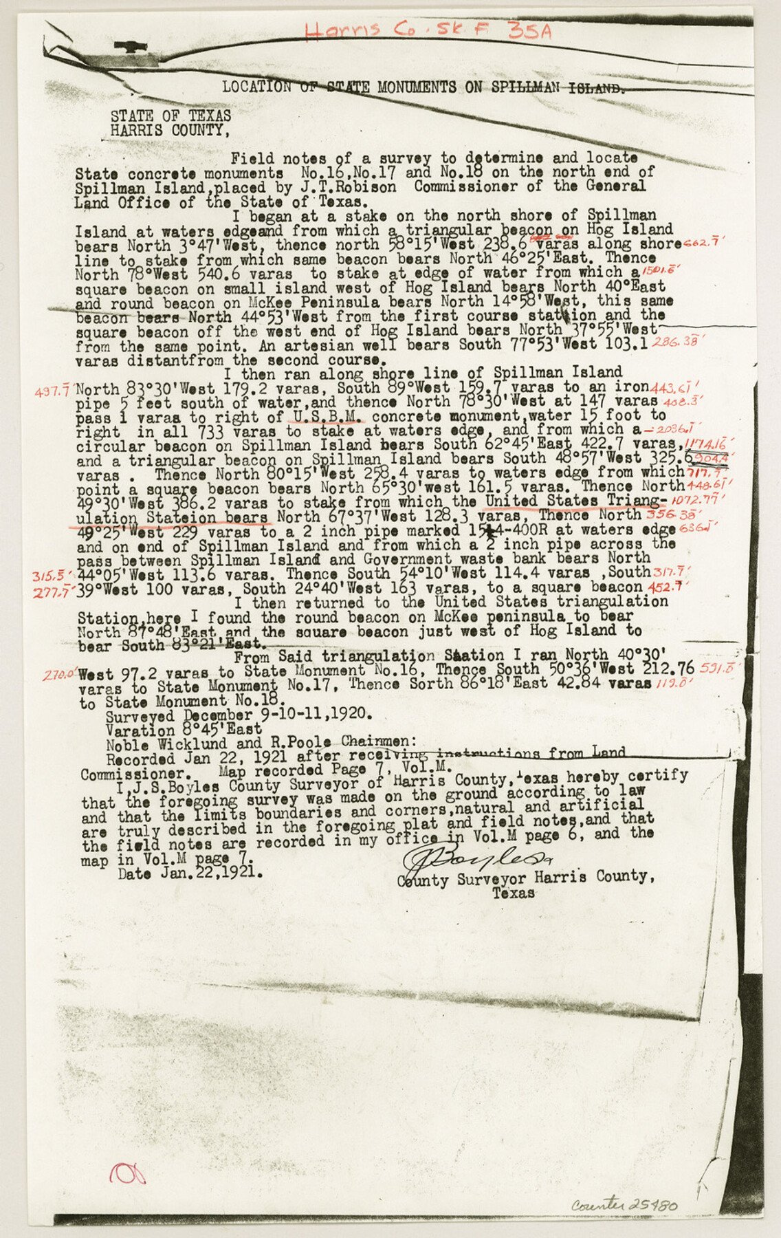
Map Showing Location of State Monuments on North end of Spillman Island and the connections of same with the State Monuments on Hog Island and Location and ties to United States Government Monuments and Beacons
-
Map/Doc
25480
-
Collection
General Map Collection
-
Object Dates
1920/12/30 (File Date)
1921/1/22 (Creation Date)
1922/2/8 (Correspondence Date)
1920/12/30 (Correspondence Date)
1920/12/28 (Correspondence Date)
1913 (Survey Date)
1916 (Survey Date)
1920/12/29 (Creation Date)
-
People and Organizations
J.S. Boyles (Surveyor/Engineer)
Austin Miller (Surveyor/Engineer)
-
Counties
Harris
-
Subjects
Surveying Sketch File
-
Height x Width
14.3 x 9.0 inches
36.3 x 22.9 cm
-
Medium
multi-page, multi-format
-
Scale
1" = 200 varas
-
Features
Spillman Island
Hog Island
McKee Peninsula
Houston Ship Channel
Mullet Island
Part of: General Map Collection
Callahan County Sketch File 12

Print $40.00
- Digital $50.00
Callahan County Sketch File 12
1872
Size 17.8 x 26.2 inches
Map/Doc 11041
King County Working Sketch 4

Print $20.00
- Digital $50.00
King County Working Sketch 4
1939
Size 42.9 x 25.7 inches
Map/Doc 70168
Map of Pecos Co.

Print $40.00
- Digital $50.00
Map of Pecos Co.
1896
Size 47.7 x 70.1 inches
Map/Doc 76038
Coast Chart No. 210 Aransas Pass and Corpus Christi Bay with the coast to latitude 27° 12' Texas

Print $20.00
- Digital $50.00
Coast Chart No. 210 Aransas Pass and Corpus Christi Bay with the coast to latitude 27° 12' Texas
1887
Size 26.6 x 18.3 inches
Map/Doc 72809
[Sketch for Mineral Applications 7410, 7411, 7412, 7413, 7712 - Kleberg County]
![65623, [Sketch for Mineral Applications 7410, 7411, 7412, 7413, 7712 - Kleberg County], General Map Collection](https://historictexasmaps.com/wmedia_w700/maps/65623-1.tif.jpg)
Print $40.00
- Digital $50.00
[Sketch for Mineral Applications 7410, 7411, 7412, 7413, 7712 - Kleberg County]
1977
Size 44.6 x 92.4 inches
Map/Doc 65623
Intracoastal Waterway, Houma, LA to Corpus Christi, TX

Print $20.00
- Digital $50.00
Intracoastal Waterway, Houma, LA to Corpus Christi, TX
Size 22.0 x 25.0 inches
Map/Doc 61905
Flight Mission No. BRA-16M, Frame 125, Jefferson County

Print $20.00
- Digital $50.00
Flight Mission No. BRA-16M, Frame 125, Jefferson County
1953
Size 18.5 x 22.6 inches
Map/Doc 85735
Runnels County Rolled Sketch 50

Print $20.00
- Digital $50.00
Runnels County Rolled Sketch 50
Size 31.3 x 26.7 inches
Map/Doc 7535
Ward County Working Sketch 13

Print $20.00
- Digital $50.00
Ward County Working Sketch 13
1947
Size 20.0 x 40.6 inches
Map/Doc 72319
Chambers County Rolled Sketch 12C

Print $97.00
- Digital $50.00
Chambers County Rolled Sketch 12C
Size 10.0 x 15.2 inches
Map/Doc 43939
Hartley County Working Sketch 3

Print $20.00
- Digital $50.00
Hartley County Working Sketch 3
1928
Size 24.6 x 24.0 inches
Map/Doc 66053

You may also like
Matagorda County Rolled Sketch 22

Print $20.00
- Digital $50.00
Matagorda County Rolled Sketch 22
Size 30.7 x 23.9 inches
Map/Doc 6689
Lampasas County Rolled Sketch 1

Print $20.00
- Digital $50.00
Lampasas County Rolled Sketch 1
1975
Size 22.0 x 28.2 inches
Map/Doc 6564
Presidio County Working Sketch 52

Print $20.00
- Digital $50.00
Presidio County Working Sketch 52
1954
Size 46.5 x 27.6 inches
Map/Doc 71729
[Leagues 445, 465-468, Block B, Gregg County School Land Leagues 1 and 2]
![90532, [Leagues 445, 465-468, Block B, Gregg County School Land Leagues 1 and 2], Twichell Survey Records](https://historictexasmaps.com/wmedia_w700/maps/90532-1.tif.jpg)
Print $2.00
- Digital $50.00
[Leagues 445, 465-468, Block B, Gregg County School Land Leagues 1 and 2]
1902
Size 9.0 x 9.9 inches
Map/Doc 90532
La Salle County Boundary File 57a

Print $6.00
- Digital $50.00
La Salle County Boundary File 57a
Size 14.3 x 8.8 inches
Map/Doc 56255

Red River Co.

Print $20.00
- Digital $50.00
Red River Co.
1897
Size 46.8 x 36.0 inches
Map/Doc 16796
Geological Highway Map of Texas

Geological Highway Map of Texas
1973
Size 27.9 x 36.5 inches
Map/Doc 77523
[Maps of surveys in Reeves & Culberson Cos]
![61135, [Maps of surveys in Reeves & Culberson Cos], General Map Collection](https://historictexasmaps.com/wmedia_w700/maps/61135.tif.jpg)
Print $20.00
- Digital $50.00
[Maps of surveys in Reeves & Culberson Cos]
1937
Size 30.6 x 24.9 inches
Map/Doc 61135
Loving County Boundary File 2

Print $40.00
- Digital $50.00
Loving County Boundary File 2
Map/Doc 90033
Denton County Sketch File 10

Print $2.00
- Digital $50.00
Denton County Sketch File 10
1856
Size 8.5 x 13.5 inches
Map/Doc 20708
Somervell County Working Sketch 7

Print $20.00
- Digital $50.00
Somervell County Working Sketch 7
2008
Size 27.9 x 34.2 inches
Map/Doc 88889