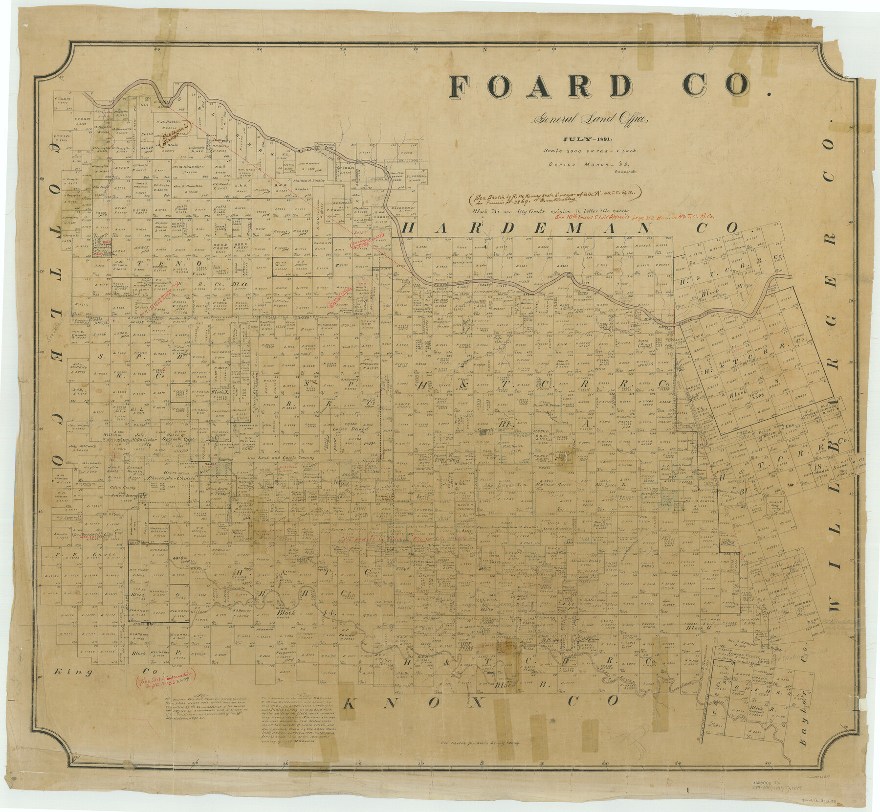
Foard Co.
-
Map/Doc
66827
-
Collection
General Map Collection
-
Object Dates
1891 (Creation Date)
-
People and Organizations
Texas General Land Office (Publisher)
-
Counties
Foard
-
Subjects
County
-
Height x Width
39.2 x 42.5 inches
99.6 x 108.0 cm
-
Comments
Copied in March 1899 by Hunnicutt.
Part of: General Map Collection
Maverick County Working Sketch 23

Print $20.00
- Digital $50.00
Maverick County Working Sketch 23
1985
Size 37.8 x 36.4 inches
Map/Doc 70915
Kendall County Working Sketch 17

Print $20.00
- Digital $50.00
Kendall County Working Sketch 17
1968
Size 31.0 x 30.9 inches
Map/Doc 66689
Hudspeth County Sketch File 33

Print $6.00
- Digital $50.00
Hudspeth County Sketch File 33
1952
Size 11.3 x 8.8 inches
Map/Doc 26994
Anderson County Sketch File 25

Print $40.00
- Digital $50.00
Anderson County Sketch File 25
1969
Size 40.9 x 21.9 inches
Map/Doc 10316
Hale County Boundary File 4a

Print $60.00
- Digital $50.00
Hale County Boundary File 4a
Size 31.2 x 41.9 inches
Map/Doc 54068
Flight Mission No. CGI-3N, Frame 179, Cameron County

Print $20.00
- Digital $50.00
Flight Mission No. CGI-3N, Frame 179, Cameron County
1954
Size 18.6 x 22.2 inches
Map/Doc 84643
Flight Mission No. DQO-8K, Frame79, Galveston County

Print $20.00
- Digital $50.00
Flight Mission No. DQO-8K, Frame79, Galveston County
1952
Size 18.7 x 22.5 inches
Map/Doc 85183
Aransas County NRC Article 33.136 Sketch 22

Print $24.00
Aransas County NRC Article 33.136 Sketch 22
2023
Map/Doc 97270
Fisher County Working Sketch 18

Print $20.00
- Digital $50.00
Fisher County Working Sketch 18
1941
Size 24.7 x 16.6 inches
Map/Doc 69152
Pecos County Rolled Sketch 97

Print $20.00
- Digital $50.00
Pecos County Rolled Sketch 97
Size 24.7 x 36.8 inches
Map/Doc 7248
Wilson County Sketch File 12

Print $8.00
- Digital $50.00
Wilson County Sketch File 12
1841
Size 14.1 x 8.6 inches
Map/Doc 40425
Montgomery County Rolled Sketch 16

Print $20.00
- Digital $50.00
Montgomery County Rolled Sketch 16
Size 28.5 x 26.6 inches
Map/Doc 6804
You may also like
Stonewall County Sketch File 18-1

Print $8.00
- Digital $50.00
Stonewall County Sketch File 18-1
1905
Size 11.3 x 8.6 inches
Map/Doc 37284
Descripcion de las Yndias Ocidentales

Print $20.00
- Digital $50.00
Descripcion de las Yndias Ocidentales
1601
Size 9.6 x 13.2 inches
Map/Doc 95962
The Republic County of Galveston. December 16, 1839

Print $20.00
The Republic County of Galveston. December 16, 1839
2020
Size 14.7 x 21.9 inches
Map/Doc 96144
Kinney County Boundary File 1

Print $94.00
- Digital $50.00
Kinney County Boundary File 1
Size 20.3 x 3.7 inches
Map/Doc 64935
Culberson County Sketch File 41

Print $20.00
- Digital $50.00
Culberson County Sketch File 41
1920
Size 12.5 x 8.8 inches
Map/Doc 20312
Flight Mission No. DIX-6P, Frame 199, Aransas County

Print $20.00
- Digital $50.00
Flight Mission No. DIX-6P, Frame 199, Aransas County
1956
Size 18.8 x 22.6 inches
Map/Doc 83861
Haskell County Working Sketch 9

Print $20.00
- Digital $50.00
Haskell County Working Sketch 9
1959
Size 23.5 x 26.0 inches
Map/Doc 66067
Flight Mission No. CGI-3N, Frame 146, Cameron County

Print $20.00
- Digital $50.00
Flight Mission No. CGI-3N, Frame 146, Cameron County
1954
Size 18.5 x 22.1 inches
Map/Doc 84619

Lamb County Working Sketch 3

Print $20.00
- Digital $50.00
Lamb County Working Sketch 3
1962
Size 32.1 x 37.7 inches
Map/Doc 70276
[Surveys possibly in Austin County]
![78356, [Surveys possibly in Austin County], General Map Collection](https://historictexasmaps.com/wmedia_w700/maps/78356.tif.jpg)
Print $3.00
- Digital $50.00
[Surveys possibly in Austin County]
Size 17.0 x 9.6 inches
Map/Doc 78356
Map of Hale County

Print $40.00
- Digital $50.00
Map of Hale County
1900
Size 49.3 x 41.0 inches
Map/Doc 4691