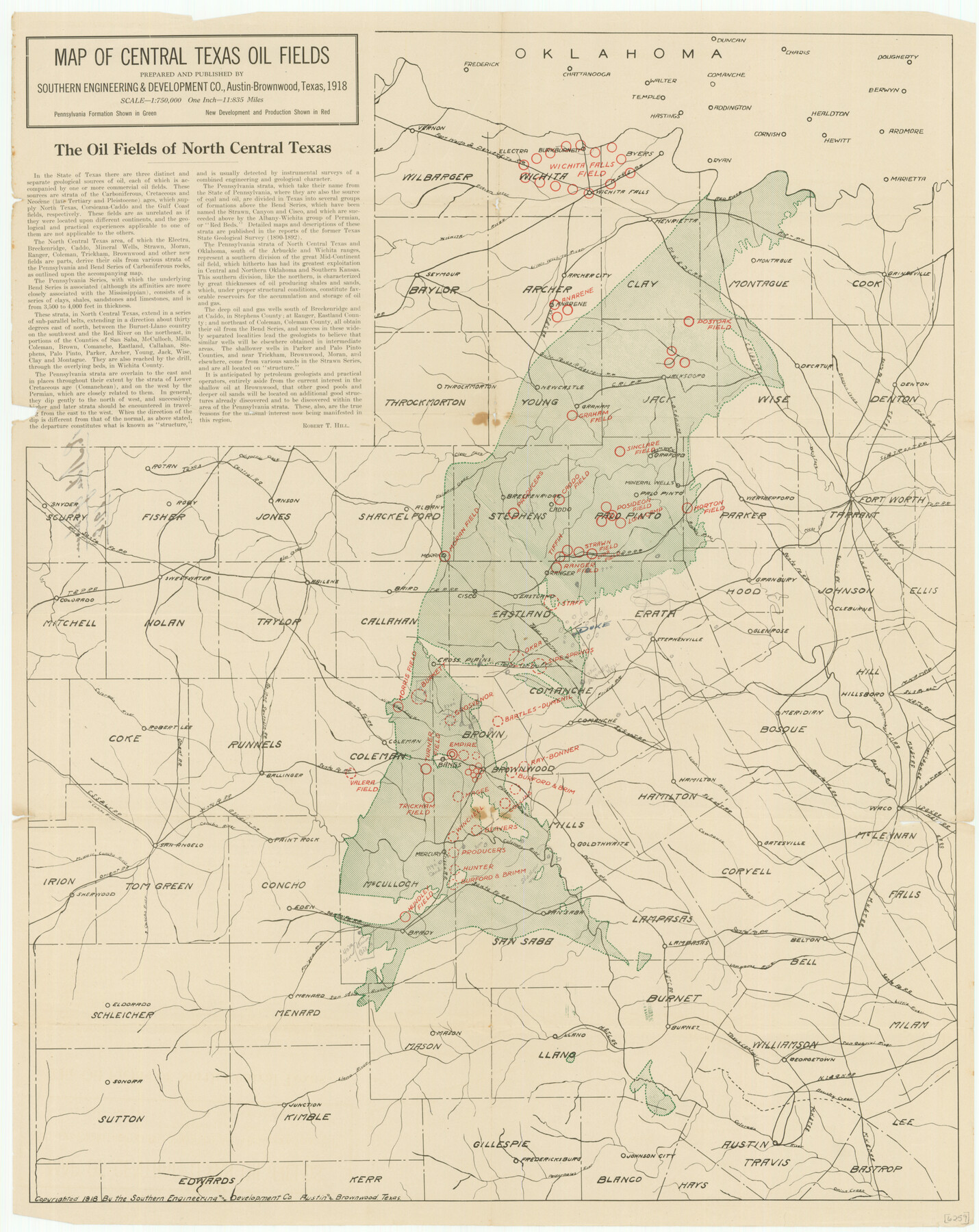
Map of Central Texas Oil Fields
-
Map/Doc
76295
-
Collection
Texas State Library and Archives
-
Object Dates
1918 (Creation Date)
-
People and Organizations
Southern Engineering and Development Company (Publisher)
-
Subjects
Energy Surface
-
Height x Width
27.1 x 21.5 inches
68.8 x 54.6 cm
-
Comments
Prints available courtesy of the Texas State Library and Archives.
More info can be found here: TSLAC Map 06259
Part of: Texas State Library and Archives
General Highway Map, Zapata County, Texas

Print $20.00
General Highway Map, Zapata County, Texas
1940
Size 18.4 x 24.8 inches
Map/Doc 79287
General Highway Map. Detail of Cities and Towns in Tom Green County, Texas. City Map, San Angelo, Tom Green County, Texas

Print $20.00
General Highway Map. Detail of Cities and Towns in Tom Green County, Texas. City Map, San Angelo, Tom Green County, Texas
1961
Size 18.1 x 24.8 inches
Map/Doc 79679
General Highway Map, Scurry County, Texas

Print $20.00
General Highway Map, Scurry County, Texas
1961
Size 18.1 x 24.8 inches
Map/Doc 79650
General Highway Map, McLennan County, Texas

Print $20.00
General Highway Map, McLennan County, Texas
1961
Size 18.2 x 24.6 inches
Map/Doc 79589
General Highway Map, Burnet County, Texas

Print $20.00
General Highway Map, Burnet County, Texas
1940
Size 18.6 x 25.2 inches
Map/Doc 79033
General Highway Map, Kenedy County, Texas

Print $20.00
General Highway Map, Kenedy County, Texas
1940
Size 18.4 x 24.9 inches
Map/Doc 79155
Preliminary Chart of the Entrance to Matagorda Bay, Texas

Print $20.00
Preliminary Chart of the Entrance to Matagorda Bay, Texas
1857
Size 20.2 x 32.9 inches
Map/Doc 76247
General Highway Map, Matagorda County, Texas

Print $20.00
General Highway Map, Matagorda County, Texas
1961
Size 24.8 x 18.2 inches
Map/Doc 79585
Section across Valley Bench and Terraces - South Side of Red River - Big Bend Area

Print $20.00
Section across Valley Bench and Terraces - South Side of Red River - Big Bend Area
1921
Size 10.2 x 34.8 inches
Map/Doc 79750
General Highway Map, Smith County, Texas

Print $20.00
General Highway Map, Smith County, Texas
1961
Size 25.1 x 18.3 inches
Map/Doc 79654
Reconnoissances of Routes from San Antonio de Bexar to El Paso Del Norte

Print $20.00
Reconnoissances of Routes from San Antonio de Bexar to El Paso Del Norte
1849
Size 27.5 x 39.6 inches
Map/Doc 76239
General Highway Map, Kent County, Texas

Print $20.00
General Highway Map, Kent County, Texas
1961
Size 18.2 x 24.6 inches
Map/Doc 79550
You may also like
Victoria County Rolled Sketch 3

Print $20.00
- Digital $50.00
Victoria County Rolled Sketch 3
1950
Size 41.9 x 37.8 inches
Map/Doc 10094
Kinney County Working Sketch 30

Print $40.00
- Digital $50.00
Kinney County Working Sketch 30
1959
Size 52.6 x 34.7 inches
Map/Doc 70212
Wilbarger County Sketch File 27

Print $4.00
- Digital $50.00
Wilbarger County Sketch File 27
1894
Size 14.0 x 8.5 inches
Map/Doc 40229
Morris County Rolled Sketch 2

Print $40.00
- Digital $50.00
Morris County Rolled Sketch 2
1944
Size 59.4 x 43.5 inches
Map/Doc 9550

Fort Bend County Sketch File 2a

Print $4.00
- Digital $50.00
Fort Bend County Sketch File 2a
Size 12.7 x 8.1 inches
Map/Doc 22878
Map of north end of Brazos Island

Print $20.00
- Digital $50.00
Map of north end of Brazos Island
Size 27.5 x 18.3 inches
Map/Doc 72906
San Augustine County Working Sketch 11a

Print $20.00
- Digital $50.00
San Augustine County Working Sketch 11a
Size 18.8 x 24.4 inches
Map/Doc 63698
Terrell County Sketch File 22W

Print $20.00
- Digital $50.00
Terrell County Sketch File 22W
Size 19.6 x 21.7 inches
Map/Doc 12423
Hardin County Working Sketch 15

Print $20.00
- Digital $50.00
Hardin County Working Sketch 15
1939
Size 21.1 x 34.6 inches
Map/Doc 63413
Burleson County

Print $20.00
- Digital $50.00
Burleson County
1920
Size 38.0 x 45.0 inches
Map/Doc 4790
Anderson County

Print $20.00
- Digital $50.00
Anderson County
1861
Size 18.0 x 21.2 inches
Map/Doc 774