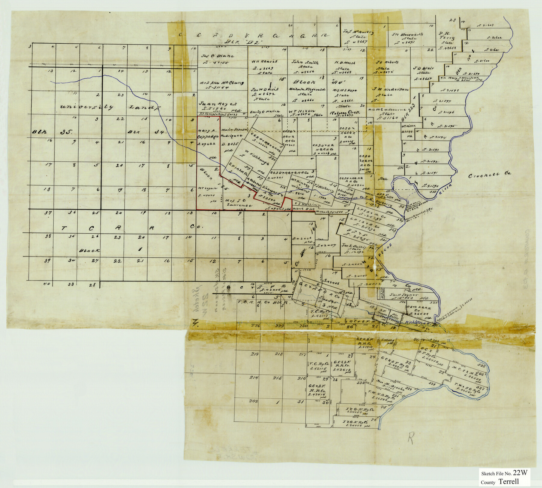
Terrell County Sketch File 22W
[Sketch of large area on the west side of the Pecos River in the northeast part of the county]
-
Map/Doc
12423
-
Collection
General Map Collection
-
Counties
Terrell
-
Subjects
Surveying Sketch File
-
Height x Width
19.6 x 21.7 inches
49.8 x 55.1 cm
-
Medium
paper, manuscript
-
Features
Independence Creek
Pecos River
Part of: General Map Collection
Dawson County Working Sketch 15

Print $20.00
- Digital $50.00
Dawson County Working Sketch 15
1955
Size 28.2 x 24.8 inches
Map/Doc 68559
Chambers County Rolled Sketch 23A

Print $40.00
- Digital $50.00
Chambers County Rolled Sketch 23A
1940
Size 77.1 x 36.0 inches
Map/Doc 8592
Presidio County Working Sketch 89

Print $20.00
- Digital $50.00
Presidio County Working Sketch 89
1972
Size 28.8 x 37.5 inches
Map/Doc 71766
Galveston County Sketch File 4

Print $6.00
- Digital $50.00
Galveston County Sketch File 4
1850
Size 12.8 x 8.0 inches
Map/Doc 23355

Flight Mission No. DCL-7C, Frame 13, Kenedy County

Print $20.00
- Digital $50.00
Flight Mission No. DCL-7C, Frame 13, Kenedy County
1943
Size 15.4 x 15.3 inches
Map/Doc 86005
Current Miscellaneous File 56

Print $10.00
- Digital $50.00
Current Miscellaneous File 56
1954
Size 12.2 x 9.2 inches
Map/Doc 74045
San Jacinto County Rolled Sketch 4

Print $20.00
- Digital $50.00
San Jacinto County Rolled Sketch 4
Size 24.3 x 32.6 inches
Map/Doc 7557
Culberson County Working Sketch 72

Print $40.00
- Digital $50.00
Culberson County Working Sketch 72
1975
Size 50.1 x 34.2 inches
Map/Doc 68526
Irion County Boundary File 1

Print $36.00
- Digital $50.00
Irion County Boundary File 1
Size 8.9 x 4.1 inches
Map/Doc 55316

Newton County Aerial Photograph Index Sheet 2

Print $20.00
- Digital $50.00
Newton County Aerial Photograph Index Sheet 2
1953
Size 23.8 x 16.7 inches
Map/Doc 83731
You may also like
General Highway Map, Hall County, Texas

Print $20.00
General Highway Map, Hall County, Texas
1940
Size 18.3 x 25.0 inches
Map/Doc 79110
General Highway Map Cochran County, Texas

Print $40.00
- Digital $50.00
General Highway Map Cochran County, Texas
1942
Size 37.4 x 50.1 inches
Map/Doc 89851
Rand McNally Standard Map of Texas

Print $20.00
Rand McNally Standard Map of Texas
1923
Size 27.7 x 40.3 inches
Map/Doc 76259
Washington County Working Sketch 2

Print $20.00
- Digital $50.00
Washington County Working Sketch 2
1981
Size 23.6 x 20.1 inches
Map/Doc 72363

Crockett County Rolled Sketch 26

Print $20.00
- Digital $50.00
Crockett County Rolled Sketch 26
Size 33.7 x 40.9 inches
Map/Doc 5585
Comanche County Sketch File 3

Print $40.00
- Digital $50.00
Comanche County Sketch File 3
1847
Size 14.8 x 15.6 inches
Map/Doc 19055
Carson County Boundary File 9

Print $74.00
- Digital $50.00
Carson County Boundary File 9
Size 9.0 x 8.9 inches
Map/Doc 51175
[Sketch for Mineral Application 16700 - Pecos River Bed]
![2808, [Sketch for Mineral Application 16700 - Pecos River Bed], General Map Collection](https://historictexasmaps.com/wmedia_w700/maps/2808.tif.jpg)
Print $20.00
- Digital $50.00
[Sketch for Mineral Application 16700 - Pecos River Bed]
1927
Size 19.9 x 30.9 inches
Map/Doc 2808
Texas compiled from the latest and best authorities

Print $20.00
- Digital $50.00
Texas compiled from the latest and best authorities
1842
Size 11.8 x 14.0 inches
Map/Doc 93864
Calhoun County Rolled Sketch 17

Print $20.00
- Digital $50.00
Calhoun County Rolled Sketch 17
1957
Size 24.6 x 30.0 inches
Map/Doc 5370
Cooke County Rolled Sketch 7

Print $20.00
- Digital $50.00
Cooke County Rolled Sketch 7
2002
Size 44.8 x 34.9 inches
Map/Doc 77525