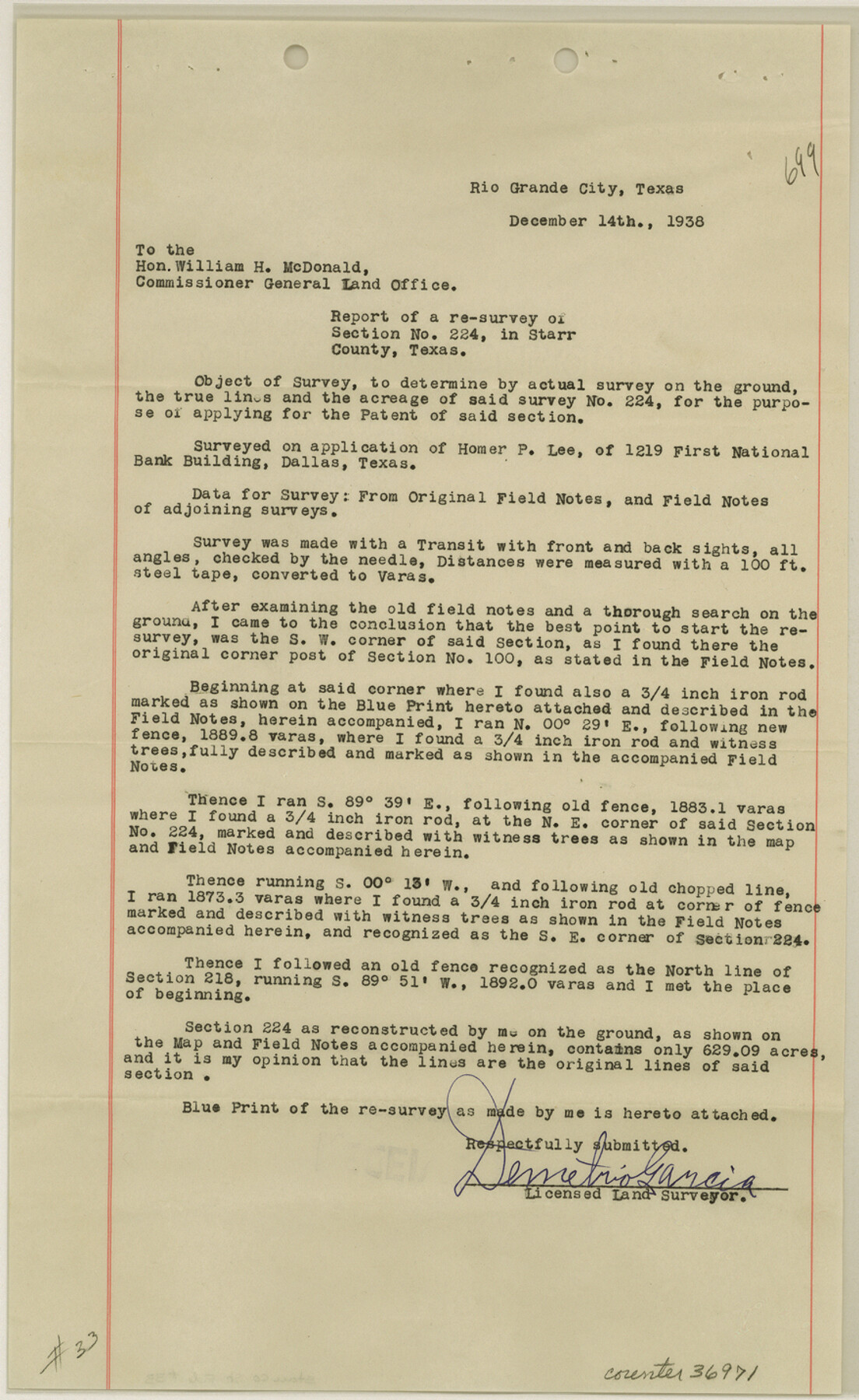
Starr County Sketch File 33
[Report and sketch of a resurvey of section 224]
-
Map/Doc
36971
-
Collection
General Map Collection
-
Object Dates
12/1938 (Creation Date)
12/19/1938 (File Date)
-
People and Organizations
Demetrio Garcia (Surveyor/Engineer)
-
Counties
Starr
-
Subjects
Surveying Sketch File
-
Height x Width
14.3 x 8.8 inches
36.3 x 22.4 cm
-
Medium
multi-page, multi-format
-
Scale
1" = 200 varas
Part of: General Map Collection
Kimble County Rolled Sketch 20

Print $20.00
- Digital $50.00
Kimble County Rolled Sketch 20
Size 14.6 x 18.1 inches
Map/Doc 6511
Runnels County Sketch File 5

Print $22.00
Runnels County Sketch File 5
Size 12.8 x 16.0 inches
Map/Doc 35436
Garza County Sketch File D1

Print $20.00
- Digital $50.00
Garza County Sketch File D1
1901
Size 14.9 x 27.3 inches
Map/Doc 11551
Bexar County Working Sketch 5

Print $20.00
- Digital $50.00
Bexar County Working Sketch 5
1943
Size 25.3 x 25.0 inches
Map/Doc 67321
Motley County Working Sketch 3

Print $20.00
- Digital $50.00
Motley County Working Sketch 3
1914
Size 13.2 x 20.4 inches
Map/Doc 71208
Matagorda County NRC Article 33.136 Sketch 18

Print $24.00
Matagorda County NRC Article 33.136 Sketch 18
2023
Map/Doc 97283
Orange County Rolled Sketch 26

Print $20.00
- Digital $50.00
Orange County Rolled Sketch 26
1952
Size 35.2 x 43.0 inches
Map/Doc 9649
Glasscock County Working Sketch 9

Print $40.00
- Digital $50.00
Glasscock County Working Sketch 9
1957
Size 77.9 x 25.5 inches
Map/Doc 63182
Ward County Rolled Sketch 12

Print $20.00
- Digital $50.00
Ward County Rolled Sketch 12
Size 38.2 x 47.8 inches
Map/Doc 10107
Erath County Sketch File 3b

Print $4.00
- Digital $50.00
Erath County Sketch File 3b
Size 10.3 x 8.3 inches
Map/Doc 22257
Goliad County Sketch File 11

Print $40.00
- Digital $50.00
Goliad County Sketch File 11
Size 13.4 x 12.5 inches
Map/Doc 24228
Map of Austin County

Print $20.00
- Digital $50.00
Map of Austin County
1863
Size 25.7 x 29.8 inches
Map/Doc 3253
You may also like
Crockett County Working Sketch 1

Print $20.00
- Digital $50.00
Crockett County Working Sketch 1
Size 20.7 x 16.7 inches
Map/Doc 68334
[Spade and Ellwood Lands in Lubbock and Hale Counties]
![91072, [Spade and Ellwood Lands in Lubbock and Hale Counties], Twichell Survey Records](https://historictexasmaps.com/wmedia_w700/maps/91072-1.tif.jpg)
Print $20.00
- Digital $50.00
[Spade and Ellwood Lands in Lubbock and Hale Counties]
Size 18.0 x 17.8 inches
Map/Doc 91072
Presidio County Rolled Sketch 144

Print $20.00
- Digital $50.00
Presidio County Rolled Sketch 144
2010
Size 36.0 x 24.0 inches
Map/Doc 89603
Location Survey of the Southern Kansas Railway, Kiowa Extension from a point in Drake's Location, in Indian Territory 100 miles from south line of Kansas, continuing up Wolf Creek and South Canadian River to Cottonwood Creek in Hutchinson County

Print $40.00
- Digital $50.00
Location Survey of the Southern Kansas Railway, Kiowa Extension from a point in Drake's Location, in Indian Territory 100 miles from south line of Kansas, continuing up Wolf Creek and South Canadian River to Cottonwood Creek in Hutchinson County
1886
Size 37.5 x 282.7 inches
Map/Doc 88837
Flight Mission No. BRE-5P, Frame 191, Nueces County

Print $20.00
- Digital $50.00
Flight Mission No. BRE-5P, Frame 191, Nueces County
1956
Size 18.7 x 22.5 inches
Map/Doc 86837
Kenedy County Rolled Sketch 6

Print $20.00
- Digital $50.00
Kenedy County Rolled Sketch 6
1911
Size 28.5 x 25.4 inches
Map/Doc 6463
Montague County Sketch File 15

Print $6.00
- Digital $50.00
Montague County Sketch File 15
1880
Size 11.0 x 15.1 inches
Map/Doc 31742

Nueces County Rolled Sketch 103

Print $105.00
Nueces County Rolled Sketch 103
1985
Size 36.5 x 24.1 inches
Map/Doc 7078
Map of Shelby County

Print $20.00
- Digital $50.00
Map of Shelby County
1839
Size 24.5 x 25.7 inches
Map/Doc 4032
Mason County Working Sketch 9

Print $20.00
- Digital $50.00
Mason County Working Sketch 9
1949
Size 34.4 x 29.4 inches
Map/Doc 70845
Hill County Boundary File 1a

Print $40.00
- Digital $50.00
Hill County Boundary File 1a
Size 18.4 x 23.3 inches
Map/Doc 54732