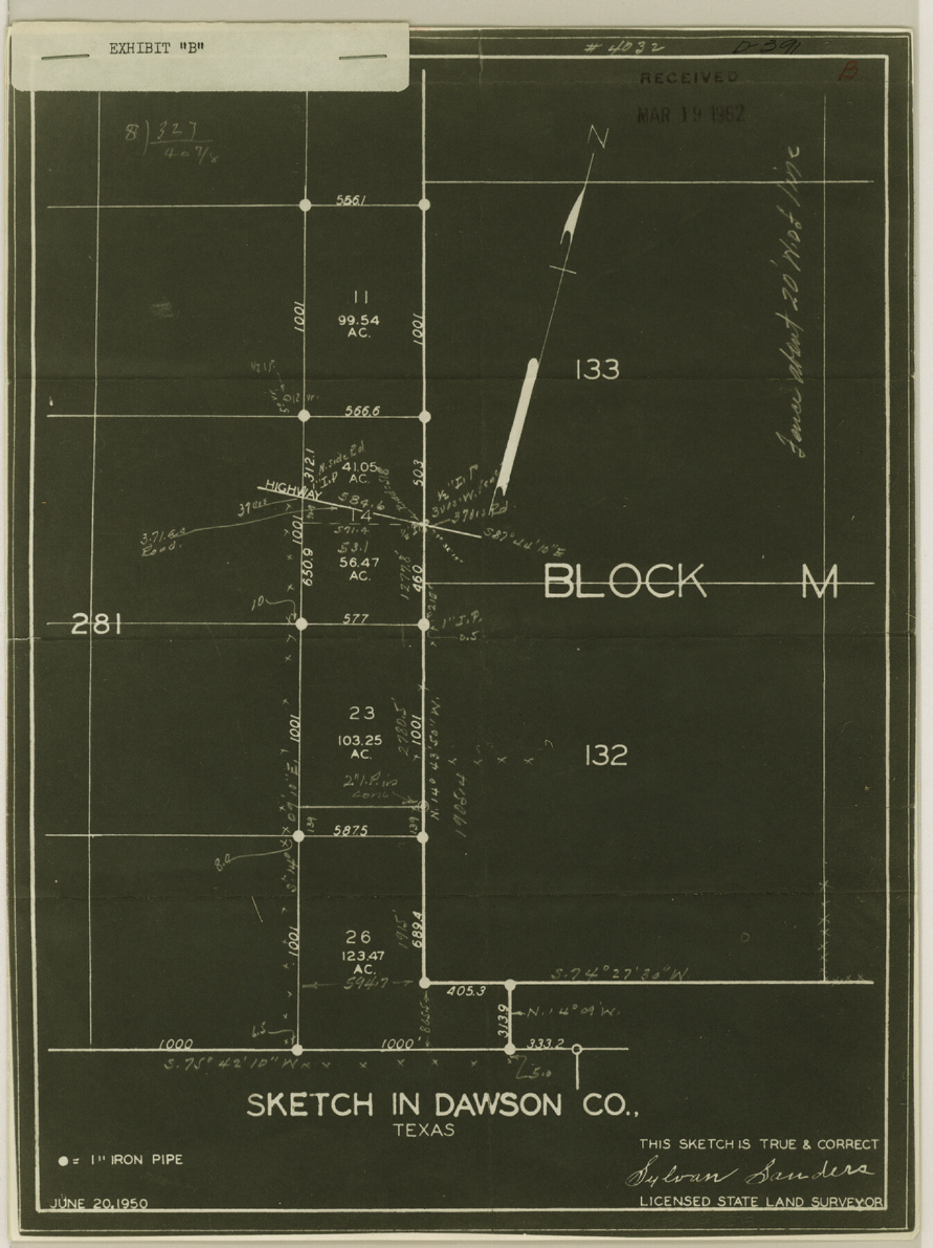
Dawson County Sketch File 25
["Exhibit B" - sketch by Sylvan Sanders submitted by R. W. Baker]
-
Map/Doc
20581
-
Collection
General Map Collection
-
Object Dates
1962/3/19 (File Date)
1950/6/20 (Creation Date)
-
People and Organizations
Sylvan Sanders (Surveyor/Engineer)
-
Counties
Dawson
-
Subjects
Surveying Sketch File
-
Height x Width
11.9 x 8.9 inches
30.2 x 22.6 cm
-
Medium
photostat, negative
Part of: General Map Collection

Jefferson County Rolled Sketch 7

Print $20.00
- Digital $50.00
Jefferson County Rolled Sketch 7
1928
Size 30.8 x 34.2 inches
Map/Doc 9272
Presidio County Working Sketch 47

Print $20.00
- Digital $50.00
Presidio County Working Sketch 47
1950
Size 30.2 x 39.5 inches
Map/Doc 71724
Right of Way and Track Map Texas & New Orleans R.R. Co. operated by the T. & N. O. R.R. Co. Dallas-Sabine Branch

Print $40.00
- Digital $50.00
Right of Way and Track Map Texas & New Orleans R.R. Co. operated by the T. & N. O. R.R. Co. Dallas-Sabine Branch
1918
Size 26.1 x 56.7 inches
Map/Doc 64150
Eastland County Working Sketch 55

Print $20.00
- Digital $50.00
Eastland County Working Sketch 55
1984
Size 33.5 x 37.8 inches
Map/Doc 68836
Harris County NRC Article 33.136 Sketch 16

Print $20.00
- Digital $50.00
Harris County NRC Article 33.136 Sketch 16
2006
Size 24.0 x 36.0 inches
Map/Doc 94823
Presidio County Sketch File S

Print $27.00
- Digital $50.00
Presidio County Sketch File S
1917
Size 14.3 x 8.8 inches
Map/Doc 34561
Bosque County Working Sketch 30

Print $20.00
- Digital $50.00
Bosque County Working Sketch 30
2009
Size 24.4 x 26.3 inches
Map/Doc 89066

Red River County

Print $20.00
- Digital $50.00
Red River County
1934
Size 45.0 x 38.6 inches
Map/Doc 77405

McCulloch County Boundary File 1

Print $40.00
- Digital $50.00
McCulloch County Boundary File 1
Size 9.2 x 33.6 inches
Map/Doc 56906
You may also like
[West half of county, south of John H. Stephens Block S2]
![90976, [West half of county, south of John H. Stephens Block S2], Twichell Survey Records](https://historictexasmaps.com/wmedia_w700/maps/90976-1.tif.jpg)
Print $2.00
- Digital $50.00
[West half of county, south of John H. Stephens Block S2]
Size 11.8 x 8.7 inches
Map/Doc 90976
Crosby County Rolled Sketch V
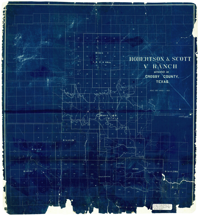
Print $20.00
- Digital $50.00
Crosby County Rolled Sketch V
Size 45.4 x 41.8 inches
Map/Doc 8739
Hicks, Station Map-Tracks & Structures Lands, San Antonio & Aransas Pass Railway Co.

Print $4.00
- Digital $50.00
Hicks, Station Map-Tracks & Structures Lands, San Antonio & Aransas Pass Railway Co.
1919
Size 11.7 x 18.6 inches
Map/Doc 62568
Midland County Working Sketch 32

Print $40.00
- Digital $50.00
Midland County Working Sketch 32
1971
Size 51.3 x 35.5 inches
Map/Doc 71013
[Plat of West Part of Section 144, Block B5]
![90602, [Plat of West Part of Section 144, Block B5], Twichell Survey Records](https://historictexasmaps.com/wmedia_w700/maps/90602-1.tif.jpg)
Print $2.00
- Digital $50.00
[Plat of West Part of Section 144, Block B5]
1931
Size 8.7 x 14.3 inches
Map/Doc 90602
Gulf of Mexico

Print $20.00
- Digital $50.00
Gulf of Mexico
1908
Size 18.2 x 27.2 inches
Map/Doc 72658
Plat of Resurvey of Sections 5, 7 and 8, T. 5S., R. 14W. Indian Meridian, Oklahoma

Print $4.00
- Digital $50.00
Plat of Resurvey of Sections 5, 7 and 8, T. 5S., R. 14W. Indian Meridian, Oklahoma
1917
Size 18.5 x 22.6 inches
Map/Doc 75140
Reagan County Rolled Sketch 4

Print $20.00
- Digital $50.00
Reagan County Rolled Sketch 4
1928
Size 25.4 x 27.4 inches
Map/Doc 7433
Goliad County Working Sketch 19

Print $20.00
- Digital $50.00
Goliad County Working Sketch 19
1954
Size 31.5 x 31.8 inches
Map/Doc 63209
Flight Mission No. DIX-8P, Frame 66, Aransas County

Print $20.00
- Digital $50.00
Flight Mission No. DIX-8P, Frame 66, Aransas County
1956
Size 18.6 x 22.2 inches
Map/Doc 83897
Foard County Sketch File X1

Print $40.00
- Digital $50.00
Foard County Sketch File X1
Size 17.6 x 14.2 inches
Map/Doc 22800
A Map of Austin's Colony and adjacent country in Texas drawn principally from actual survey by Stephen F. Austin

A Map of Austin's Colony and adjacent country in Texas drawn principally from actual survey by Stephen F. Austin
1820
Size 13.8 x 17.0 inches
Map/Doc 93353