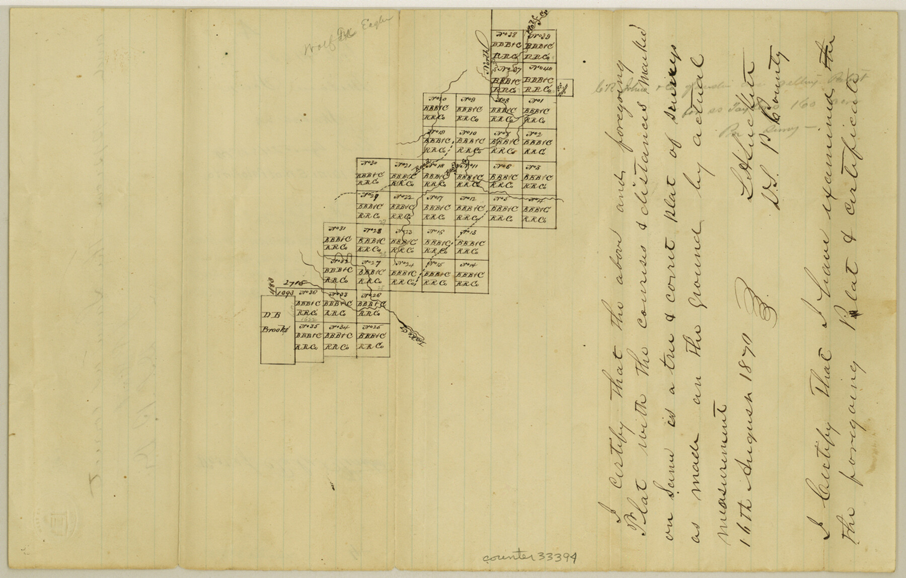
Palo Pinto County Sketch File 4
[Sketch southwest of Palo Pinto showing B. B. B. & C. RR. Co. surveys]
-
Map/Doc
33394
-
Collection
General Map Collection
-
Object Dates
8/16/1870 (Creation Date)
8/24/1870 (File Date)
-
People and Organizations
L.H. Luckett (Surveyor/Engineer)
-
Counties
Palo Pinto
-
Subjects
Surveying Sketch File
-
Height x Width
8.2 x 12.9 inches
20.8 x 32.8 cm
-
Medium
paper, manuscript
-
Features
Lake Creek
Wolf Creek
Part of: General Map Collection

Maps of Gulf Intracoastal Waterway, Texas - Sabine River to the Rio Grande and connecting waterways including ship channels

Print $20.00
- Digital $50.00
Maps of Gulf Intracoastal Waterway, Texas - Sabine River to the Rio Grande and connecting waterways including ship channels
1966
Size 14.5 x 22.2 inches
Map/Doc 61972
Matagorda County Rolled Sketch 28

Print $20.00
- Digital $50.00
Matagorda County Rolled Sketch 28
1945
Size 33.3 x 43.4 inches
Map/Doc 9481
Roberts County

Print $20.00
- Digital $50.00
Roberts County
1900
Size 43.4 x 42.0 inches
Map/Doc 63002
Brazoria County Working Sketch 9

Print $20.00
- Digital $50.00
Brazoria County Working Sketch 9
1934
Size 36.6 x 35.9 inches
Map/Doc 67494

Motley County Working Sketch Graphic Index

Print $20.00
- Digital $50.00
Motley County Working Sketch Graphic Index
1966
Size 42.3 x 33.3 inches
Map/Doc 76650
Flight Mission No. BQR-9K, Frame 7, Brazoria County

Print $20.00
- Digital $50.00
Flight Mission No. BQR-9K, Frame 7, Brazoria County
1952
Size 18.7 x 22.5 inches
Map/Doc 84036
Presidio County Sketch File 61

Print $3.00
- Digital $50.00
Presidio County Sketch File 61
1930
Size 9.3 x 15.4 inches
Map/Doc 89987
Harris County Working Sketch 10

Print $20.00
- Digital $50.00
Harris County Working Sketch 10
1912
Size 25.7 x 18.1 inches
Map/Doc 65902
South Part Pecos County

Print $20.00
- Digital $50.00
South Part Pecos County
1976
Size 36.8 x 44.2 inches
Map/Doc 73262
Real County Working Sketch 78

Print $20.00
- Digital $50.00
Real County Working Sketch 78
1980
Size 33.9 x 35.5 inches
Map/Doc 71970
You may also like
Upshur County

Print $20.00
- Digital $50.00
Upshur County
1945
Size 37.7 x 33.5 inches
Map/Doc 77442
Panola County Working Sketch 41

Print $20.00
- Digital $50.00
Panola County Working Sketch 41
1995
Map/Doc 71450
[Blocks W, A4, A2, T, D10, B, JD, O, JK4]
![92251, [Blocks W, A4, A2, T, D10, B, JD, O, JK4], Twichell Survey Records](https://historictexasmaps.com/wmedia_w700/maps/92251-1.tif.jpg)
Print $20.00
- Digital $50.00
[Blocks W, A4, A2, T, D10, B, JD, O, JK4]
Size 36.9 x 30.1 inches
Map/Doc 92251
San Jacinto County Working Sketch 22

Print $20.00
- Digital $50.00
San Jacinto County Working Sketch 22
1940
Size 21.3 x 25.3 inches
Map/Doc 63735
Panhandle of Texas

Print $20.00
- Digital $50.00
Panhandle of Texas
1907
Size 11.4 x 14.4 inches
Map/Doc 95889
[Surveys just south of Runnels County School Land Survey No. 3]
![91552, [Surveys just south of Runnels County School Land Survey No. 3], Twichell Survey Records](https://historictexasmaps.com/wmedia_w700/maps/91552-1.tif.jpg)
Print $20.00
- Digital $50.00
[Surveys just south of Runnels County School Land Survey No. 3]
1926
Size 19.4 x 13.1 inches
Map/Doc 91552
El Paso County Sketch File 35 (6)

Print $20.00
- Digital $50.00
El Paso County Sketch File 35 (6)
1886
Size 20.3 x 36.9 inches
Map/Doc 11460
The Peters Colony. January 20, 1843

Print $20.00
The Peters Colony. January 20, 1843
2020
Size 17.2 x 21.7 inches
Map/Doc 96365
Shackelford County Working Sketch 2

Print $20.00
- Digital $50.00
Shackelford County Working Sketch 2
1914
Size 17.2 x 17.3 inches
Map/Doc 63842
Kimble County Working Sketch 16

Print $20.00
- Digital $50.00
Kimble County Working Sketch 16
1923
Size 22.9 x 17.1 inches
Map/Doc 70084
[Map Showing Distances from Marshall]
![89908, [Map Showing Distances from Marshall], Twichell Survey Records](https://historictexasmaps.com/wmedia_w700/maps/89908-1.tif.jpg)
Print $40.00
- Digital $50.00
[Map Showing Distances from Marshall]
Size 45.0 x 51.4 inches
Map/Doc 89908
Intracoastal Waterway, Houma, LA to Corpus Christi, TX

Print $5.00
- Digital $50.00
Intracoastal Waterway, Houma, LA to Corpus Christi, TX
Size 22.0 x 30.0 inches
Map/Doc 61912