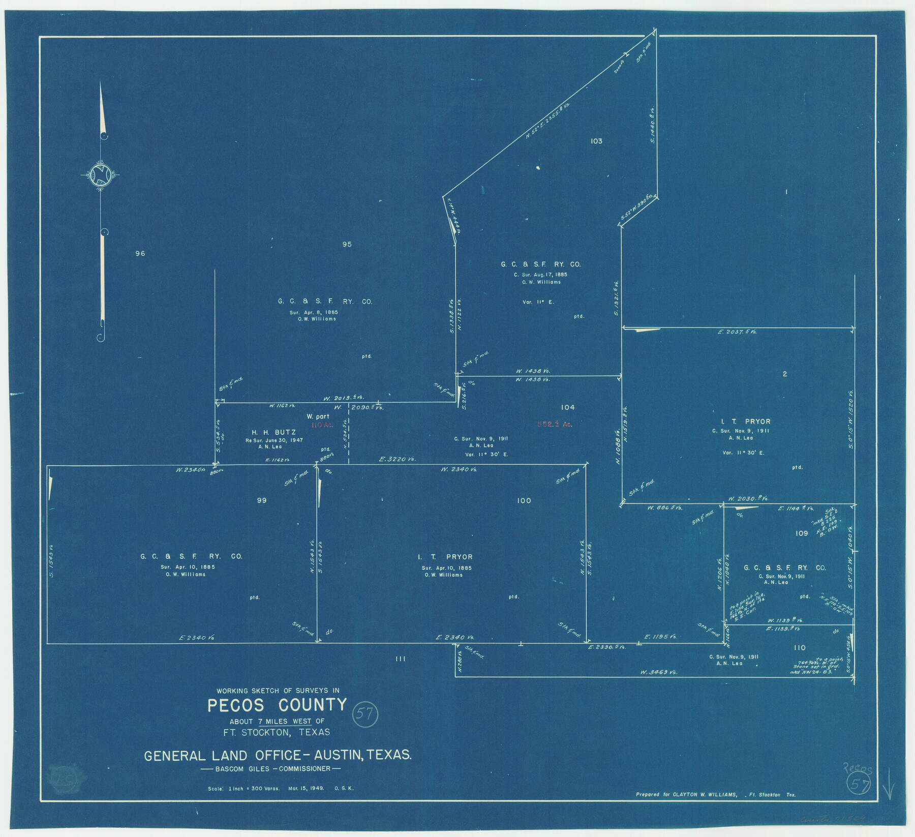
Pecos County Working Sketch 57
-
Map/Doc
71529
-
Collection
General Map Collection
-
Object Dates
3/15/1949 (Creation Date)
-
People and Organizations
Otto G. Kurio (Draftsman)
-
Counties
Pecos
-
Subjects
Surveying Working Sketch
-
Height x Width
24.2 x 26.4 inches
61.5 x 67.1 cm
-
Scale
1" = 300 varas
Part of: General Map Collection
Nacogdoches County Working Sketch 8

Print $20.00
- Digital $50.00
Nacogdoches County Working Sketch 8
1964
Size 28.0 x 22.7 inches
Map/Doc 71224
Padre Island, Register No. 1485b

Print $40.00
- Digital $50.00
Padre Island, Register No. 1485b
1881
Size 55.6 x 37.3 inches
Map/Doc 73608
Wichita County Working Sketch 8

Print $20.00
- Digital $50.00
Wichita County Working Sketch 8
1919
Size 18.3 x 37.7 inches
Map/Doc 72517
Crosby County Sketch File 15a

Print $20.00
- Digital $50.00
Crosby County Sketch File 15a
1907
Size 37.6 x 41.1 inches
Map/Doc 10352
Colorado River, East Bernard Sheet

Print $4.00
- Digital $50.00
Colorado River, East Bernard Sheet
1939
Size 24.3 x 29.9 inches
Map/Doc 65308
Newton County Aerial Photograph Index Sheet 4

Print $20.00
- Digital $50.00
Newton County Aerial Photograph Index Sheet 4
1953
Size 23.8 x 16.5 inches
Map/Doc 83733
Dimmit County Working Sketch Graphic Index - sheet B

Print $40.00
- Digital $50.00
Dimmit County Working Sketch Graphic Index - sheet B
1976
Size 41.5 x 49.9 inches
Map/Doc 76525
Childress County Sketch File 15

Print $8.00
- Digital $50.00
Childress County Sketch File 15
Size 14.3 x 8.3 inches
Map/Doc 18278
Henderson County

Print $40.00
- Digital $50.00
Henderson County
1922
Size 33.3 x 62.4 inches
Map/Doc 1854
Limestone County Sketch File 4

Print $20.00
- Digital $50.00
Limestone County Sketch File 4
1847
Size 15.2 x 34.1 inches
Map/Doc 12001
Coleman County Sketch File 34

Print $28.00
- Digital $50.00
Coleman County Sketch File 34
1878
Size 12.8 x 8.1 inches
Map/Doc 18726
Montgomery County Working Sketch 56

Print $20.00
- Digital $50.00
Montgomery County Working Sketch 56
1961
Size 21.2 x 24.0 inches
Map/Doc 71163
You may also like
Presidio County Sketch File 108

Print $6.00
- Digital $50.00
Presidio County Sketch File 108
Size 10.9 x 8.5 inches
Map/Doc 41455
Roberts County, State of Texas

Print $20.00
Roberts County, State of Texas
1888
Size 21.6 x 16.4 inches
Map/Doc 88990
Map of Harris District

Print $20.00
- Digital $50.00
Map of Harris District
1847
Size 25.4 x 34.4 inches
Map/Doc 1680
Flight Mission No. DCL-7C, Frame 150, Kenedy County

Print $20.00
- Digital $50.00
Flight Mission No. DCL-7C, Frame 150, Kenedy County
1943
Size 18.5 x 22.2 inches
Map/Doc 86107
[Surveys in Robertson's Colony]
![78358, [Surveys in Robertson's Colony], General Map Collection](https://historictexasmaps.com/wmedia_w700/maps/78358.tif.jpg)
Print $20.00
- Digital $50.00
[Surveys in Robertson's Colony]
Size 18.6 x 26.5 inches
Map/Doc 78358
Navarro County

Print $40.00
- Digital $50.00
Navarro County
1924
Size 41.1 x 48.2 inches
Map/Doc 77382
Menard County Rolled Sketch 16

Print $20.00
- Digital $50.00
Menard County Rolled Sketch 16
1983
Size 29.8 x 36.6 inches
Map/Doc 6762
Flight Mission No. CLL-4N, Frame 32, Willacy County

Print $20.00
- Digital $50.00
Flight Mission No. CLL-4N, Frame 32, Willacy County
1954
Size 18.5 x 22.1 inches
Map/Doc 87105
Lipscomb County Boundary File 14a

Print $4.00
- Digital $50.00
Lipscomb County Boundary File 14a
Size 11.3 x 8.7 inches
Map/Doc 56368
Harris County Rolled Sketch 74

Print $20.00
- Digital $50.00
Harris County Rolled Sketch 74
Size 19.1 x 33.3 inches
Map/Doc 6112
Red River County Working Sketch 65

Print $20.00
- Digital $50.00
Red River County Working Sketch 65
1973
Size 29.1 x 24.2 inches
Map/Doc 72048
Chambers County NRC Article 33.136 Location Key Sheet

Print $20.00
- Digital $50.00
Chambers County NRC Article 33.136 Location Key Sheet
1982
Size 27.0 x 22.3 inches
Map/Doc 82999