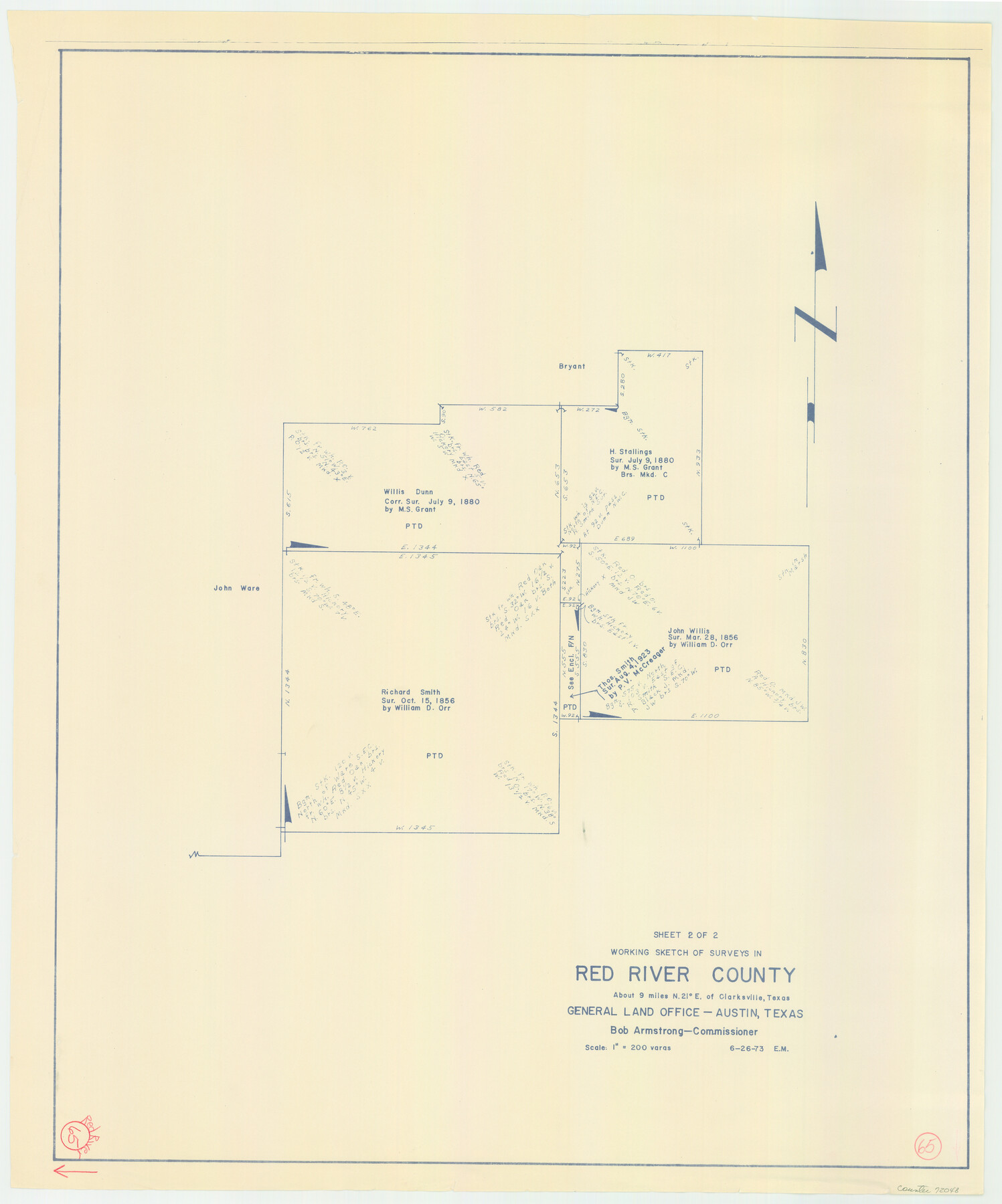
Red River County Working Sketch 65
-
Map/Doc
72048
-
Collection
General Map Collection
-
Object Dates
6/26/1973 (Creation Date)
-
People and Organizations
Elbert Menzel (Draftsman)
-
Counties
Red River
-
Subjects
Surveying Working Sketch
-
Height x Width
29.1 x 24.2 inches
73.9 x 61.5 cm
-
Scale
1" = 200 varas
Part of: General Map Collection
Medina County Sketch File 1

Print $4.00
- Digital $50.00
Medina County Sketch File 1
Size 12.5 x 8.1 inches
Map/Doc 31437
Wood County Working Sketch 22

Print $20.00
- Digital $50.00
Wood County Working Sketch 22
1962
Size 45.9 x 36.6 inches
Map/Doc 62022
Edwards County Boundary File 28

Print $50.00
- Digital $50.00
Edwards County Boundary File 28
Size 12.9 x 5.2 inches
Map/Doc 52932
Dawson County Working Sketch 12

Print $20.00
- Digital $50.00
Dawson County Working Sketch 12
1951
Size 24.6 x 27.7 inches
Map/Doc 68556
[From the lower corner of the Juan Zambrano survey to the Medina River]
![97, [From the lower corner of the Juan Zambrano survey to the Medina River], General Map Collection](https://historictexasmaps.com/wmedia_w700/maps/97.tif.jpg)
Print $20.00
- Digital $50.00
[From the lower corner of the Juan Zambrano survey to the Medina River]
1844
Size 19.0 x 8.0 inches
Map/Doc 97

Brewster County Sketch File NS-5

Print $22.00
- Digital $50.00
Brewster County Sketch File NS-5
Size 11.2 x 8.8 inches
Map/Doc 15983
Glasscock County Rolled Sketch 6

Print $20.00
- Digital $50.00
Glasscock County Rolled Sketch 6
1946
Size 19.9 x 22.5 inches
Map/Doc 6017
Panola County Working Sketch 27

Print $20.00
- Digital $50.00
Panola County Working Sketch 27
1956
Map/Doc 71436
Loving County Working Sketch 16

Print $40.00
- Digital $50.00
Loving County Working Sketch 16
1973
Size 33.3 x 54.1 inches
Map/Doc 70649
Borden County Boundary File 7

Print $29.00
- Digital $50.00
Borden County Boundary File 7
1965
Size 11.2 x 8.8 inches
Map/Doc 61161
Baylor County Rolled Sketch 8

Print $20.00
- Digital $50.00
Baylor County Rolled Sketch 8
1883
Size 12.9 x 18.4 inches
Map/Doc 5124
You may also like
Mitchell County Sketch File 14

Print $20.00
- Digital $50.00
Mitchell County Sketch File 14
1930
Size 17.5 x 20.5 inches
Map/Doc 12101
Runnels County Rolled Sketch 34

Print $20.00
- Digital $50.00
Runnels County Rolled Sketch 34
1950
Size 30.8 x 35.5 inches
Map/Doc 7521
Liberty County Rolled Sketch R

Print $40.00
- Digital $50.00
Liberty County Rolled Sketch R
Size 51.7 x 36.5 inches
Map/Doc 10656
Working Sketch Bastrop County

Print $20.00
- Digital $50.00
Working Sketch Bastrop County
1923
Size 22.7 x 13.2 inches
Map/Doc 90149
Carson County Boundary File 1

Print $8.00
- Digital $50.00
Carson County Boundary File 1
Size 8.8 x 7.4 inches
Map/Doc 51117
Foard County Sketch File 12

Print $4.00
- Digital $50.00
Foard County Sketch File 12
1881
Size 11.0 x 8.5 inches
Map/Doc 22814
Texas Coordinate File 3

Print $40.00
- Digital $50.00
Texas Coordinate File 3
Size 36.1 x 49.1 inches
Map/Doc 75306
Sherman County Rolled Sketch 12

Print $40.00
- Digital $50.00
Sherman County Rolled Sketch 12
1951
Size 11.1 x 63.8 inches
Map/Doc 9929
Lubbock County Sketch File 2

Print $4.00
- Digital $50.00
Lubbock County Sketch File 2
Size 4.7 x 9.2 inches
Map/Doc 30418
Yoakum County

Print $20.00
- Digital $50.00
Yoakum County
1932
Size 45.7 x 34.1 inches
Map/Doc 73331
Flight Mission No. CRC-4R, Frame 182, Chambers County

Print $20.00
- Digital $50.00
Flight Mission No. CRC-4R, Frame 182, Chambers County
1956
Size 18.5 x 22.1 inches
Map/Doc 84933
Flight Mission No. DAG-14K, Frame 144, Matagorda County

Print $20.00
- Digital $50.00
Flight Mission No. DAG-14K, Frame 144, Matagorda County
1952
Size 17.2 x 17.2 inches
Map/Doc 86311