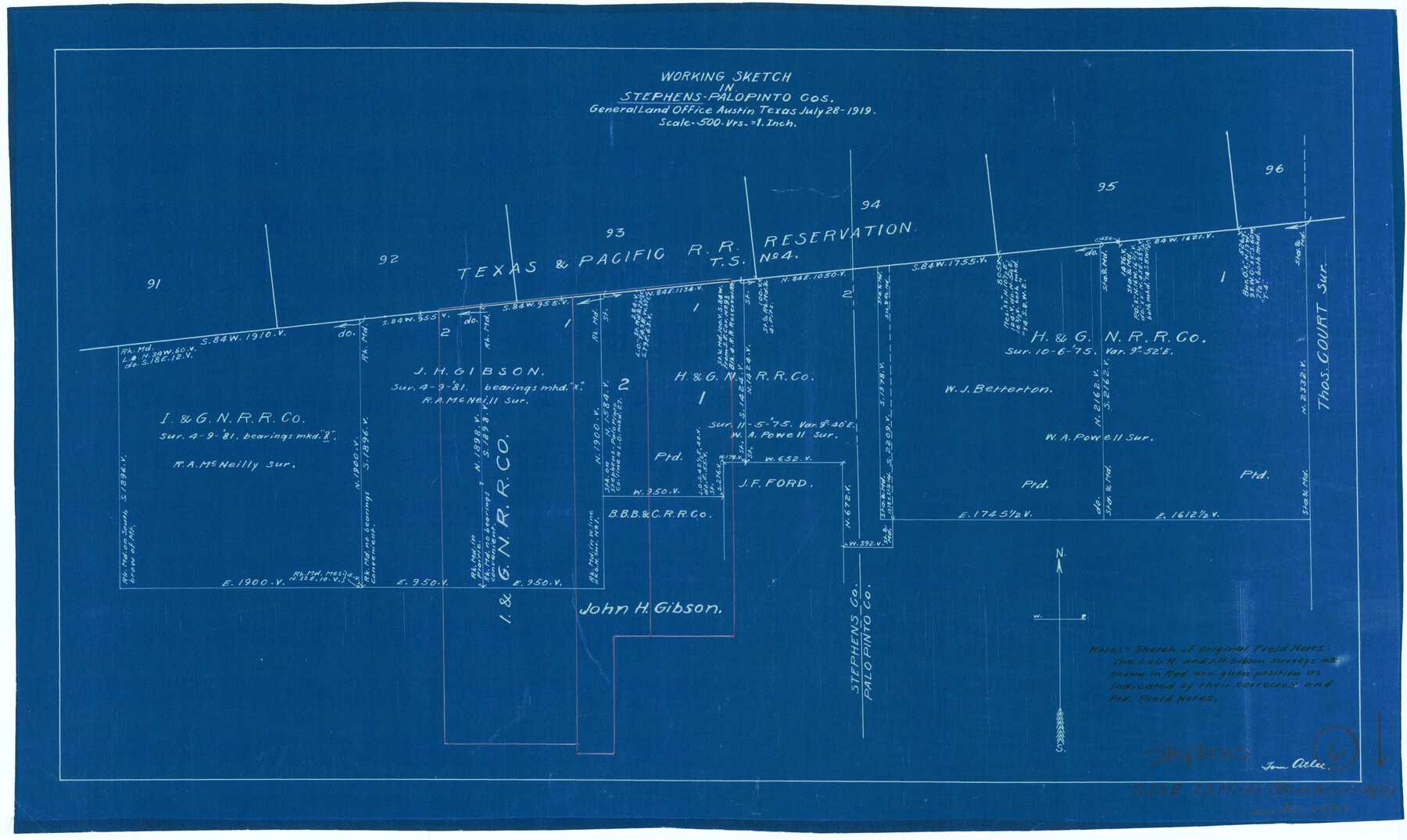
Stephens County Working Sketch 6
-
Map/Doc
63949
-
Collection
General Map Collection
-
Object Dates
7/28/1919 (Creation Date)
-
People and Organizations
Tom Atlee (Draftsman)
-
Counties
Stephens Palo Pinto
-
Subjects
Surveying Working Sketch
-
Height x Width
13.1 x 22.0 inches
33.3 x 55.9 cm
-
Scale
1" = 500 varas
Part of: General Map Collection
Intracoastal Waterway in Texas - Corpus Christi to Point Isabel including Arroyo Colorado to Mo. Pac. R.R. Bridge Near Harlingen

Print $20.00
- Digital $50.00
Intracoastal Waterway in Texas - Corpus Christi to Point Isabel including Arroyo Colorado to Mo. Pac. R.R. Bridge Near Harlingen
1933
Size 28.2 x 40.8 inches
Map/Doc 61852
Harris County Working Sketch 68

Print $20.00
- Digital $50.00
Harris County Working Sketch 68
1955
Size 29.3 x 24.3 inches
Map/Doc 65960
El Paso County Boundary File 22

Print $4.00
- Digital $50.00
El Paso County Boundary File 22
Size 13.6 x 8.6 inches
Map/Doc 53216
Irion County Rolled Sketch 6

Print $20.00
- Digital $50.00
Irion County Rolled Sketch 6
Size 23.6 x 39.9 inches
Map/Doc 6320
Smith County Working Sketch 1

Print $20.00
- Digital $50.00
Smith County Working Sketch 1
Size 16.3 x 13.0 inches
Map/Doc 63886
Montgomery County Rolled Sketch 10A
Print $20.00
- Digital $50.00
Montgomery County Rolled Sketch 10A
Size 12.1 x 18.1 inches
Map/Doc 6800
Flight Mission No. BRA-6M, Frame 152, Jefferson County

Print $20.00
- Digital $50.00
Flight Mission No. BRA-6M, Frame 152, Jefferson County
1953
Size 18.6 x 22.3 inches
Map/Doc 85453
Briscoe County Boundary File 1

Print $90.00
- Digital $50.00
Briscoe County Boundary File 1
Size 8.6 x 6.8 inches
Map/Doc 50758
[Surveys near the Neches River]
![8, [Surveys near the Neches River], General Map Collection](https://historictexasmaps.com/wmedia_w700/maps/8.tif.jpg)
Print $3.00
- Digital $50.00
[Surveys near the Neches River]
Size 17.2 x 10.3 inches
Map/Doc 8
Flight Mission No. DAH-9M, Frame 162, Orange County

Print $20.00
- Digital $50.00
Flight Mission No. DAH-9M, Frame 162, Orange County
1953
Size 18.6 x 22.3 inches
Map/Doc 86861
Hartley County Sketch File 8

Print $20.00
- Digital $50.00
Hartley County Sketch File 8
Size 23.9 x 19.1 inches
Map/Doc 11699
El Paso County Rolled Sketch Z53

Print $40.00
- Digital $50.00
El Paso County Rolled Sketch Z53
1915
Size 36.6 x 51.7 inches
Map/Doc 8869
You may also like
Val Verde County Sketch File 51a

Print $8.00
- Digital $50.00
Val Verde County Sketch File 51a
1959
Size 11.4 x 8.8 inches
Map/Doc 39325
A Topographical Map of the Government Tract Adjoining the City of Austin

Print $20.00
- Digital $50.00
A Topographical Map of the Government Tract Adjoining the City of Austin
1840
Size 40.7 x 36.1 inches
Map/Doc 2177

[Young Territory]
![16784, [Young Territory], General Map Collection](https://historictexasmaps.com/wmedia_w700/maps/16784.tif.jpg)
Print $40.00
- Digital $50.00
[Young Territory]
1875
Size 49.0 x 87.4 inches
Map/Doc 16784
Navigation Maps of Gulf Intracoastal Waterway, Port Arthur to Brownsville, Texas

Print $4.00
- Digital $50.00
Navigation Maps of Gulf Intracoastal Waterway, Port Arthur to Brownsville, Texas
1951
Size 16.7 x 21.6 inches
Map/Doc 65447
Hardeman County Rolled Sketch 15

Print $20.00
- Digital $50.00
Hardeman County Rolled Sketch 15
1890
Size 18.0 x 23.0 inches
Map/Doc 6072
PSL Field Notes for Block CS in Hartley County

PSL Field Notes for Block CS in Hartley County
Map/Doc 81656
Kaufman County Boundary File 5a

Print $28.00
- Digital $50.00
Kaufman County Boundary File 5a
Size 14.2 x 8.8 inches
Map/Doc 55951
Aransas County Sketch File 21b

Print $4.00
- Digital $50.00
Aransas County Sketch File 21b
Size 8.7 x 14.2 inches
Map/Doc 13160
University Land Loving-Ward-Winkler Counties

Print $20.00
- Digital $50.00
University Land Loving-Ward-Winkler Counties
1931
Size 24.7 x 33.2 inches
Map/Doc 2448
Chambers County Sketch File 17

Print $40.00
- Digital $50.00
Chambers County Sketch File 17
1878
Size 12.4 x 15.6 inches
Map/Doc 17567
Maps of Gulf Intracoastal Waterway, Texas - Sabine River to the Rio Grande and connecting waterways including ship channels

Print $20.00
- Digital $50.00
Maps of Gulf Intracoastal Waterway, Texas - Sabine River to the Rio Grande and connecting waterways including ship channels
1966
Size 14.5 x 22.2 inches
Map/Doc 61919