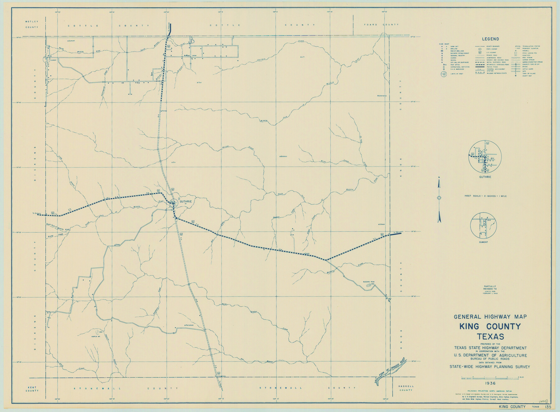
General Highway Map, King County, Texas
-
Map/Doc
79161
-
Collection
Texas State Library and Archives
-
Object Dates
1940 (Creation Date)
-
People and Organizations
Texas State Highway Department (Publisher)
-
Counties
King
-
Subjects
County
-
Height x Width
18.3 x 24.8 inches
46.5 x 63.0 cm
-
Comments
Prints available courtesy of the Texas State Library and Archives.
More info can be found here: TSLAC Map 04919
Part of: Texas State Library and Archives
General Highway Map Supplementary Sheet Showing Detail of Cities and Towns in Bexar County Texas

Print $20.00
General Highway Map Supplementary Sheet Showing Detail of Cities and Towns in Bexar County Texas
1936
Size 18.5 x 25.0 inches
Map/Doc 76290
General Highway Map, Hale County, Texas

Print $20.00
General Highway Map, Hale County, Texas
1940
Size 24.8 x 18.4 inches
Map/Doc 79108
General Highway Map, Live Oak County, Texas

Print $20.00
General Highway Map, Live Oak County, Texas
1961
Size 18.2 x 24.8 inches
Map/Doc 79574
Pocket Map of the State of Texas reduced from their original map of the State and drawn by Chas. W. Pressler and A. B. Langermann

Print $20.00
Pocket Map of the State of Texas reduced from their original map of the State and drawn by Chas. W. Pressler and A. B. Langermann
1879
Size 24.4 x 26.3 inches
Map/Doc 76208
General Highway Map, Matagorda County, Texas

Print $20.00
General Highway Map, Matagorda County, Texas
1961
Size 24.7 x 18.2 inches
Map/Doc 79586
General Highway Map, La Salle County, Texas

Print $20.00
General Highway Map, La Salle County, Texas
1961
Size 18.2 x 24.8 inches
Map/Doc 79565
General Highway Map. Detail of Cities and Towns in Taylor County, Texas [Abilene and vicinity]
![79673, General Highway Map. Detail of Cities and Towns in Taylor County, Texas [Abilene and vicinity], Texas State Library and Archives](https://historictexasmaps.com/wmedia_w700/maps/79673.tif.jpg)
Print $20.00
General Highway Map. Detail of Cities and Towns in Taylor County, Texas [Abilene and vicinity]
1961
Size 18.2 x 24.8 inches
Map/Doc 79673
General Highway Map. Detail of Cities and Towns in Fort Bend County, Texas

Print $20.00
General Highway Map. Detail of Cities and Towns in Fort Bend County, Texas
1961
Size 18.1 x 24.5 inches
Map/Doc 79470
General Highway Map. Detail of Cities and Towns in Hale County, Texas [Plainview and vicinity]
![79109, General Highway Map. Detail of Cities and Towns in Hale County, Texas [Plainview and vicinity], Texas State Library and Archives](https://historictexasmaps.com/wmedia_w700/maps/79109.tif.jpg)
Print $20.00
General Highway Map. Detail of Cities and Towns in Hale County, Texas [Plainview and vicinity]
1940
Size 25.0 x 18.5 inches
Map/Doc 79109
[Plat of San Marcos, Texas]
![79312, [Plat of San Marcos, Texas], Texas State Library and Archives](https://historictexasmaps.com/wmedia_w700/maps/79312.tif.jpg)
Print $20.00
[Plat of San Marcos, Texas]
1890
Size 18.9 x 15.9 inches
Map/Doc 79312

General Highway Map, Kimble County, Texas

Print $20.00
General Highway Map, Kimble County, Texas
1940
Size 24.8 x 18.3 inches
Map/Doc 79160
You may also like
Rusk County Working Sketch 21

Print $20.00
- Digital $50.00
Rusk County Working Sketch 21
1953
Size 27.6 x 28.3 inches
Map/Doc 63657
Jackson County Boundary File 4

Print $4.00
- Digital $50.00
Jackson County Boundary File 4
Size 10.2 x 7.9 inches
Map/Doc 55460
Hays County Sketch File 25a

Print $2.00
- Digital $50.00
Hays County Sketch File 25a
1881
Size 10.2 x 8.0 inches
Map/Doc 26251
Matagorda County Working Sketch 17

Print $20.00
- Digital $50.00
Matagorda County Working Sketch 17
1961
Size 31.2 x 42.2 inches
Map/Doc 70875
Montague County Working Sketch 1

Print $20.00
- Digital $50.00
Montague County Working Sketch 1
Size 18.7 x 32.5 inches
Map/Doc 71067
Pecos County Rolled Sketch 146C

Print $20.00
- Digital $50.00
Pecos County Rolled Sketch 146C
Size 43.1 x 39.5 inches
Map/Doc 9743
Knox County Sketch File 9

Print $4.00
- Digital $50.00
Knox County Sketch File 9
1889
Size 11.1 x 8.8 inches
Map/Doc 29221
Stonewall County Working Sketch 34

Print $20.00
- Digital $50.00
Stonewall County Working Sketch 34
1985
Size 34.0 x 33.9 inches
Map/Doc 62341

Freestone County Rolled Sketch 14

Print $20.00
- Digital $50.00
Freestone County Rolled Sketch 14
Size 29.4 x 19.8 inches
Map/Doc 78601
St. Louis, Brownsville & Mexico Railway Location Map from Mile 40 to Mile 60

Print $40.00
- Digital $50.00
St. Louis, Brownsville & Mexico Railway Location Map from Mile 40 to Mile 60
1905
Size 20.3 x 136.1 inches
Map/Doc 89282
Jack County Sketch File 37

Print $4.00
- Digital $50.00
Jack County Sketch File 37
1963
Size 3.5 x 7.6 inches
Map/Doc 27615