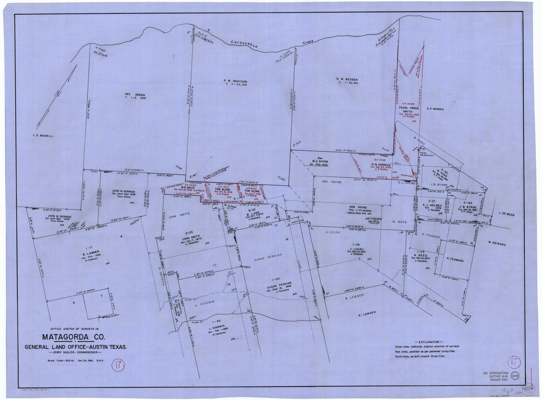
Matagorda County Working Sketch 17
-
Map/Doc
70875
-
Collection
General Map Collection
-
Object Dates
1/24/1961 (Creation Date)
-
People and Organizations
Otto G. Kurio (Draftsman)
-
Counties
Matagorda
-
Subjects
Surveying Working Sketch
-
Height x Width
31.2 x 42.2 inches
79.3 x 107.2 cm
-
Scale
1" = 500 varas
Part of: General Map Collection
Brewster County Working Sketch 106

Print $20.00
- Digital $50.00
Brewster County Working Sketch 106
1980
Size 43.3 x 31.8 inches
Map/Doc 67706
Tarrant County Boundary File 2

Print $6.00
- Digital $50.00
Tarrant County Boundary File 2
Size 14.4 x 9.0 inches
Map/Doc 59111
San Patricio County Sketch File 24

Print $10.00
San Patricio County Sketch File 24
1918
Size 10.0 x 4.3 inches
Map/Doc 36078
Railroad Track Map, H&TCRRCo., Falls County, Texas

Print $4.00
- Digital $50.00
Railroad Track Map, H&TCRRCo., Falls County, Texas
1918
Size 11.7 x 18.5 inches
Map/Doc 62854
Pecos County Rolled Sketch 124

Print $20.00
- Digital $50.00
Pecos County Rolled Sketch 124
Size 22.8 x 18.8 inches
Map/Doc 7265
Brewster Co[unty]
![16947, Brewster Co[unty], General Map Collection](https://historictexasmaps.com/wmedia_w700/maps/16947.tif.jpg)
Print $40.00
- Digital $50.00
Brewster Co[unty]
1904
Size 63.5 x 48.0 inches
Map/Doc 16947
Amistad International Reservoir on Rio Grande 72

Print $20.00
- Digital $50.00
Amistad International Reservoir on Rio Grande 72
1949
Size 28.4 x 39.6 inches
Map/Doc 73360
Presidio County

Print $40.00
- Digital $50.00
Presidio County
1875
Size 97.8 x 33.5 inches
Map/Doc 88867
Williamson County

Print $40.00
- Digital $50.00
Williamson County
1946
Size 37.3 x 54.8 inches
Map/Doc 77460
Flight Mission No. DQN-2K, Frame 89, Calhoun County

Print $20.00
- Digital $50.00
Flight Mission No. DQN-2K, Frame 89, Calhoun County
1953
Size 16.2 x 15.7 inches
Map/Doc 84279
Township No. 1 North Range No. 27 West Indian Meridian

Print $20.00
- Digital $50.00
Township No. 1 North Range No. 27 West Indian Meridian
1875
Size 19.3 x 24.6 inches
Map/Doc 75170

You may also like
Pecos County Sketch File 105

Print $4.00
- Digital $50.00
Pecos County Sketch File 105
1965
Size 14.3 x 8.8 inches
Map/Doc 34028
Flight Mission No. BRE-2P, Frame 134, Nueces County

Print $20.00
- Digital $50.00
Flight Mission No. BRE-2P, Frame 134, Nueces County
1956
Size 18.4 x 22.3 inches
Map/Doc 86807
Carson County Sketch File 3

Print $32.00
- Digital $50.00
Carson County Sketch File 3
1888
Size 5.4 x 8.4 inches
Map/Doc 17335
Mitchell Estate Subdivision

Print $20.00
- Digital $50.00
Mitchell Estate Subdivision
1953
Size 9.3 x 19.8 inches
Map/Doc 92505
McMullen County

Print $20.00
- Digital $50.00
McMullen County
1889
Size 12.4 x 16.4 inches
Map/Doc 92957
Carte de la Louisiane et du Cours du Mississipi

Print $20.00
- Digital $50.00
Carte de la Louisiane et du Cours du Mississipi
1718
Size 21.7 x 28.6 inches
Map/Doc 95161
Subdivision of Tract 2, Soash-White Industrial Addition, Part of Southeast Quarter, Section 2, Block E (Geo. W. Soash - J. B. White, Owners)

Print $20.00
- Digital $50.00
Subdivision of Tract 2, Soash-White Industrial Addition, Part of Southeast Quarter, Section 2, Block E (Geo. W. Soash - J. B. White, Owners)
1956
Size 22.8 x 17.6 inches
Map/Doc 92775
New Guide to Spanish and Mexican Land Grants in South Texas

Price $15.00
New Guide to Spanish and Mexican Land Grants in South Texas
2009
Size 11.0 x 8.5 inches
Map/Doc 83388
Flight Mission No. DCL-5C, Frame 27, Kenedy County

Print $20.00
- Digital $50.00
Flight Mission No. DCL-5C, Frame 27, Kenedy County
1943
Size 18.5 x 22.4 inches
Map/Doc 85839
Plat of NE portion of Leagues 3 & 4, McLennan Co. School Land taken from official map filed in District Court

Print $3.00
- Digital $50.00
Plat of NE portion of Leagues 3 & 4, McLennan Co. School Land taken from official map filed in District Court
Size 11.6 x 9.9 inches
Map/Doc 90927
Tech Memorial Park, Inc. Catholic Section

Print $20.00
- Digital $50.00
Tech Memorial Park, Inc. Catholic Section
Size 18.1 x 26.5 inches
Map/Doc 92348
Williamson County Sketch File 16

Print $20.00
- Digital $50.00
Williamson County Sketch File 16
Size 16.8 x 25.5 inches
Map/Doc 12693