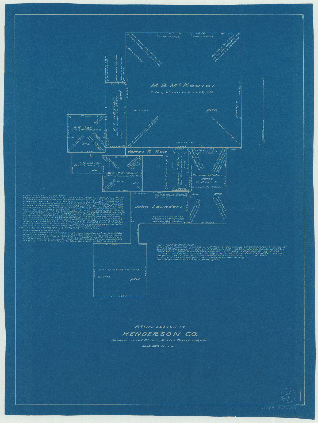
Henderson County Working Sketch 4
-
Map/Doc
66137
-
Collection
General Map Collection
-
Object Dates
10/25/1918 (Creation Date)
-
People and Organizations
G.T. Wicker (Draftsman)
-
Counties
Henderson
-
Subjects
Surveying Working Sketch
-
Height x Width
21.2 x 16.0 inches
53.9 x 40.6 cm
-
Scale
1" = 500 varas
Part of: General Map Collection
Pecos County Rolled Sketch 82

Print $20.00
- Digital $50.00
Pecos County Rolled Sketch 82
1930
Size 29.0 x 26.4 inches
Map/Doc 10192
Cherokee County Sketch File 31

Print $6.00
- Digital $50.00
Cherokee County Sketch File 31
1934
Size 14.0 x 8.9 inches
Map/Doc 18184
Lavaca County Rolled Sketch 8

Print $40.00
- Digital $50.00
Lavaca County Rolled Sketch 8
1982
Size 36.5 x 65.6 inches
Map/Doc 10289
Caldwell County Working Sketch 12

Print $20.00
- Digital $50.00
Caldwell County Working Sketch 12
1979
Size 47.7 x 44.2 inches
Map/Doc 67842
Goliad County Sketch File 1

Print $24.00
- Digital $50.00
Goliad County Sketch File 1
1857
Size 12.5 x 7.5 inches
Map/Doc 24211
Castro County Sketch File 16

Print $4.00
- Digital $50.00
Castro County Sketch File 16
1891
Size 11.0 x 8.8 inches
Map/Doc 17513
Ector County Sketch File 12

Print $12.00
- Digital $50.00
Ector County Sketch File 12
1956
Size 11.4 x 9.0 inches
Map/Doc 21645
La Salle County Working Sketch 38

Print $20.00
- Digital $50.00
La Salle County Working Sketch 38
1961
Size 26.6 x 18.4 inches
Map/Doc 70339
Orange County Sketch File 14a

Print $4.00
- Digital $50.00
Orange County Sketch File 14a
1886
Size 8.1 x 10.2 inches
Map/Doc 33328
North Part of El Paso Co.

Print $20.00
- Digital $50.00
North Part of El Paso Co.
1977
Size 30.5 x 40.5 inches
Map/Doc 77273
Flight Mission No. CUG-3P, Frame 194, Kleberg County

Print $20.00
- Digital $50.00
Flight Mission No. CUG-3P, Frame 194, Kleberg County
1956
Size 18.4 x 22.2 inches
Map/Doc 86298
San Augustine County Working Sketch 21

Print $40.00
- Digital $50.00
San Augustine County Working Sketch 21
1973
Size 56.1 x 47.4 inches
Map/Doc 63709
You may also like
[Blocks M-25 and H]
![92978, [Blocks M-25 and H], Twichell Survey Records](https://historictexasmaps.com/wmedia_w700/maps/92978-1.tif.jpg)
Print $20.00
- Digital $50.00
[Blocks M-25 and H]
1922
Size 17.5 x 13.9 inches
Map/Doc 92978
Edwards County Sketch File 45

Print $26.00
- Digital $50.00
Edwards County Sketch File 45
1890
Size 13.3 x 8.4 inches
Map/Doc 21779
Grayson County Sketch File 20

Print $4.00
- Digital $50.00
Grayson County Sketch File 20
1861
Size 10.1 x 8.1 inches
Map/Doc 24493
Working Sketch Bastrop County

Print $20.00
- Digital $50.00
Working Sketch Bastrop County
1923
Size 16.7 x 13.1 inches
Map/Doc 90117
Map of the Fort Worth and Denver City Railway, through Wilbarger County Texas, 1882

Print $40.00
- Digital $50.00
Map of the Fort Worth and Denver City Railway, through Wilbarger County Texas, 1882
Size 22.9 x 121.1 inches
Map/Doc 64426
Sterling County Sketch File 11

Print $40.00
- Digital $50.00
Sterling County Sketch File 11
1929
Size 14.2 x 17.2 inches
Map/Doc 37148
Wood County Sketch File 5a

Print $4.00
- Digital $50.00
Wood County Sketch File 5a
1857
Size 10.1 x 8.0 inches
Map/Doc 40639
Fort Bend County Working Sketch 16

Print $20.00
- Digital $50.00
Fort Bend County Working Sketch 16
1953
Size 42.4 x 46.0 inches
Map/Doc 69222
Tarrant County Rolled Sketch 4

Print $20.00
- Digital $50.00
Tarrant County Rolled Sketch 4
1982
Size 27.2 x 19.2 inches
Map/Doc 7912
General Highway Map, Presidio County, Texas

Print $20.00
General Highway Map, Presidio County, Texas
1961
Size 24.5 x 18.3 inches
Map/Doc 79633
Van Zandt County Sketch File 46

Print $2.00
- Digital $50.00
Van Zandt County Sketch File 46
Size 8.0 x 12.7 inches
Map/Doc 39503
Webb County Working Sketch 62

Print $20.00
- Digital $50.00
Webb County Working Sketch 62
1962
Size 24.8 x 29.9 inches
Map/Doc 72428