Nueces County Rolled Sketch 87
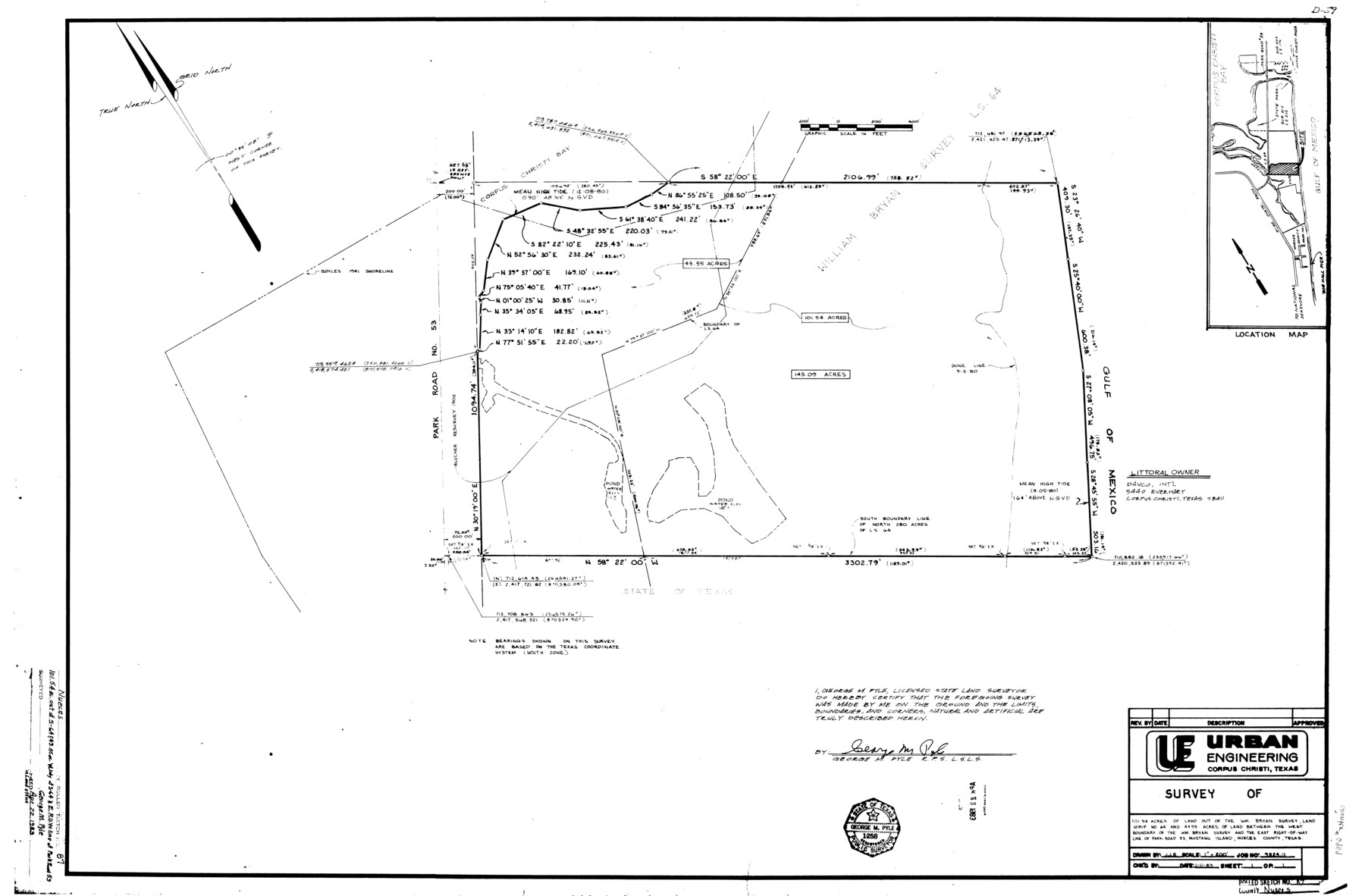
Survey of 101.54 acres of land out of the Wm. Bryan survey, land scrip no. 64 and 43.55 acres of land between the west boundary of the Wm. Bryan survey and the east right-of-way line of Park Road 53, Mustang Island, Nueces County, Texas
-
Map/Doc
6989
-
Collection
General Map Collection
-
Object Dates
1983/4/22 (File Date)
1983/1/11 (Creation Date)
-
People and Organizations
George M. Pyle (Surveyor/Engineer)
-
Counties
Nueces
-
Subjects
Surveying Rolled Sketch
-
Height x Width
24.2 x 36.9 inches
61.5 x 93.7 cm
-
Medium
mylar, print
-
Scale
1" = 200 feet
-
Comments
See Nueces County Sketch File 68 (33000) for report.
Related maps
Nueces County Sketch File 68

Print $8.00
- Digital $50.00
Nueces County Sketch File 68
Size 11.0 x 8.7 inches
Map/Doc 33000
Part of: General Map Collection
Polk County Working Sketch 41

Print $20.00
- Digital $50.00
Polk County Working Sketch 41
1985
Size 26.3 x 27.8 inches
Map/Doc 71658
Flight Mission No. DAH-17M, Frame 61, Orange County

Print $20.00
- Digital $50.00
Flight Mission No. DAH-17M, Frame 61, Orange County
1953
Size 18.6 x 22.5 inches
Map/Doc 86895
Hudspeth County Working Sketch 19

Print $20.00
- Digital $50.00
Hudspeth County Working Sketch 19
1959
Size 21.5 x 24.3 inches
Map/Doc 66301
Anderson County Sketch File 7

Print $4.00
- Digital $50.00
Anderson County Sketch File 7
Size 7.9 x 10.0 inches
Map/Doc 12757
Morris County Rolled Sketch 2A

Print $20.00
- Digital $50.00
Morris County Rolled Sketch 2A
Size 24.0 x 18.8 inches
Map/Doc 10273
Haskell County Rolled Sketch 13

Print $3.00
- Digital $50.00
Haskell County Rolled Sketch 13
1991
Size 11.0 x 17.1 inches
Map/Doc 6171
Presidio County Working Sketch 13

Print $20.00
- Digital $50.00
Presidio County Working Sketch 13
1941
Size 25.7 x 41.5 inches
Map/Doc 71689
Van Zandt County Sketch File 40

Print $4.00
- Digital $50.00
Van Zandt County Sketch File 40
Size 8.6 x 9.4 inches
Map/Doc 39486
Hays County Boundary File 2

Print $40.00
- Digital $50.00
Hays County Boundary File 2
Size 6.9 x 26.1 inches
Map/Doc 54593
Hays County Working Sketch 23

Print $20.00
- Digital $50.00
Hays County Working Sketch 23
2011
Size 30.5 x 29.2 inches
Map/Doc 90090
Val Verde County Working Sketch 22

Print $20.00
- Digital $50.00
Val Verde County Working Sketch 22
1931
Size 27.6 x 33.0 inches
Map/Doc 72157
San Patricio County Rolled Sketch 4

Print $20.00
- Digital $50.00
San Patricio County Rolled Sketch 4
1875
Size 18.4 x 28.8 inches
Map/Doc 7572
You may also like
Archer County Working Sketch 17

Print $3.00
- Digital $50.00
Archer County Working Sketch 17
1951
Size 10.7 x 12.2 inches
Map/Doc 67158
Borden County Working Sketch 8

Print $20.00
- Digital $50.00
Borden County Working Sketch 8
1951
Size 24.7 x 34.4 inches
Map/Doc 67468
Hale County Sketch File 24

Print $22.00
- Digital $50.00
Hale County Sketch File 24
1908
Size 8.9 x 7.9 inches
Map/Doc 24761
Original Town of Nadine, Lea County, New Mexico

Print $20.00
- Digital $50.00
Original Town of Nadine, Lea County, New Mexico
1928
Size 27.6 x 34.0 inches
Map/Doc 92434
Hudspeth County Working Sketch 1

Print $40.00
- Digital $50.00
Hudspeth County Working Sketch 1
1911
Size 26.5 x 53.3 inches
Map/Doc 69023
Brazoria County Working Sketch 21

Print $20.00
- Digital $50.00
Brazoria County Working Sketch 21
1954
Size 41.5 x 41.8 inches
Map/Doc 67506
Comanche County Working Sketch 16

Print $20.00
- Digital $50.00
Comanche County Working Sketch 16
1969
Size 16.5 x 23.8 inches
Map/Doc 68150
[Sketch of part of G. & M. Block 5, G. & M. Block 4, Block M19 and Block 21W]
![93085, [Sketch of part of G. & M. Block 5, G. & M. Block 4, Block M19 and Block 21W], Twichell Survey Records](https://historictexasmaps.com/wmedia_w700/maps/93085-1.tif.jpg)
Print $20.00
- Digital $50.00
[Sketch of part of G. & M. Block 5, G. & M. Block 4, Block M19 and Block 21W]
Size 23.1 x 17.8 inches
Map/Doc 93085
Flight Mission No. BQR-9K, Frame 5, Brazoria County

Print $20.00
- Digital $50.00
Flight Mission No. BQR-9K, Frame 5, Brazoria County
1952
Size 18.7 x 22.3 inches
Map/Doc 84034
La Salle County Sketch File 41

Print $20.00
- Digital $50.00
La Salle County Sketch File 41
1918
Size 25.8 x 15.9 inches
Map/Doc 11986
Hudspeth County Working Sketch 50

Print $20.00
- Digital $50.00
Hudspeth County Working Sketch 50
Size 24.6 x 37.2 inches
Map/Doc 66335
Blanco County Rolled Sketch 8

Print $20.00
- Digital $50.00
Blanco County Rolled Sketch 8
Size 19.1 x 27.7 inches
Map/Doc 5145