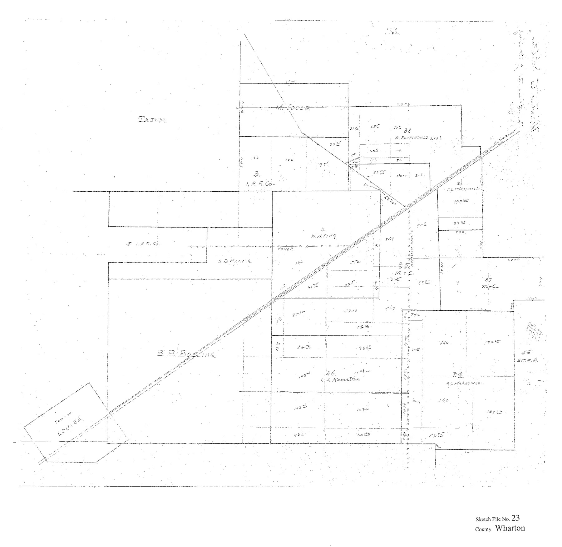
Wharton County Sketch File 23
[Sketch of surveys northeast of the town of Louise]
-
Map/Doc
12667
-
Collection
General Map Collection
-
Object Dates
12/9/1918 (File Date)
-
People and Organizations
F.J. Hardey (Surveyor/Engineer)
-
Counties
Wharton
-
Subjects
Surveying Sketch File
-
Height x Width
19.3 x 19.9 inches
49.0 x 50.6 cm
-
Medium
paper, print
Part of: General Map Collection
Stephens County Working Sketch 41

Print $40.00
- Digital $50.00
Stephens County Working Sketch 41
2008
Size 34.1 x 48.0 inches
Map/Doc 88737
Maps & Lists Showing Prison Lands (Oil & Gas) Leased as of June 1955

Digital $50.00
Maps & Lists Showing Prison Lands (Oil & Gas) Leased as of June 1955
Size 8.9 x 11.3 inches
Map/Doc 62870
Angelina County Working Sketch 11

Print $20.00
- Digital $50.00
Angelina County Working Sketch 11
1934
Size 40.9 x 31.8 inches
Map/Doc 67092
Fisher County Rolled Sketch 7

Print $20.00
- Digital $50.00
Fisher County Rolled Sketch 7
2009
Size 28.6 x 24.6 inches
Map/Doc 89988
Austin County Sketch File EF

Print $40.00
- Digital $50.00
Austin County Sketch File EF
1895
Size 15.1 x 17.0 inches
Map/Doc 10879
Flight Mission No. CUG-2P, Frame 64, Kleberg County

Print $20.00
- Digital $50.00
Flight Mission No. CUG-2P, Frame 64, Kleberg County
1956
Size 18.4 x 22.2 inches
Map/Doc 86201
Louisiana and Texas Intracoastal Waterway - Dredging Tributary Channel, Port Aransas to Aransas Pass, Texas

Print $20.00
- Digital $50.00
Louisiana and Texas Intracoastal Waterway - Dredging Tributary Channel, Port Aransas to Aransas Pass, Texas
1940
Size 31.1 x 42.3 inches
Map/Doc 61820

Presidio County Sketch File 111

Print $4.00
- Digital $50.00
Presidio County Sketch File 111
1885
Size 14.3 x 9.1 inches
Map/Doc 34824
Gillespie County Working Sketch 3

Print $20.00
- Digital $50.00
Gillespie County Working Sketch 3
1960
Size 23.0 x 21.7 inches
Map/Doc 63166
United States - Gulf Coast - Galveston to Rio Grande

Print $20.00
- Digital $50.00
United States - Gulf Coast - Galveston to Rio Grande
1941
Size 27.2 x 18.2 inches
Map/Doc 72753
Jones County Working Sketch 5

Print $20.00
- Digital $50.00
Jones County Working Sketch 5
1950
Size 35.5 x 29.3 inches
Map/Doc 66643
You may also like
Schleicher County Sketch File 47

Print $4.00
- Digital $50.00
Schleicher County Sketch File 47
1953
Size 4.4 x 8.7 inches
Map/Doc 36556
La Salle County Sketch File 20A

Print $29.00
- Digital $50.00
La Salle County Sketch File 20A
1852
Size 19.5 x 33.6 inches
Map/Doc 11984
Atascosa County Rolled Sketch 10

Print $40.00
- Digital $50.00
Atascosa County Rolled Sketch 10
1943
Size 36.0 x 77.6 inches
Map/Doc 8428
Flight Mission No. BRE-1P, Frame 119, Nueces County

Print $20.00
- Digital $50.00
Flight Mission No. BRE-1P, Frame 119, Nueces County
1956
Size 18.7 x 22.7 inches
Map/Doc 86685
Flight Mission No. DQN-5K, Frame 60, Calhoun County

Print $20.00
- Digital $50.00
Flight Mission No. DQN-5K, Frame 60, Calhoun County
1953
Size 15.5 x 15.4 inches
Map/Doc 84403
Flight Mission No. DQN-2K, Frame 94, Calhoun County

Print $20.00
- Digital $50.00
Flight Mission No. DQN-2K, Frame 94, Calhoun County
1953
Size 16.6 x 16.2 inches
Map/Doc 84284
Guadalupe County

Print $20.00
- Digital $50.00
Guadalupe County
1977
Size 36.5 x 47.8 inches
Map/Doc 95515
Karnes County Sketch File 2

Print $6.00
- Digital $50.00
Karnes County Sketch File 2
1851
Size 12.5 x 8.1 inches
Map/Doc 28547
Williamson County Sketch File 24

Print $12.00
- Digital $50.00
Williamson County Sketch File 24
1877
Size 12.8 x 8.1 inches
Map/Doc 40355
Williamson County Sketch File 18

Print $6.00
- Digital $50.00
Williamson County Sketch File 18
1871
Size 12.8 x 8.1 inches
Map/Doc 40342
Navarro County Working Sketch 13

Print $20.00
- Digital $50.00
Navarro County Working Sketch 13
1980
Size 15.6 x 16.1 inches
Map/Doc 71243
Armstrong County Sketch File 4a

Print $4.00
- Digital $50.00
Armstrong County Sketch File 4a
1883
Size 14.3 x 8.9 inches
Map/Doc 13687