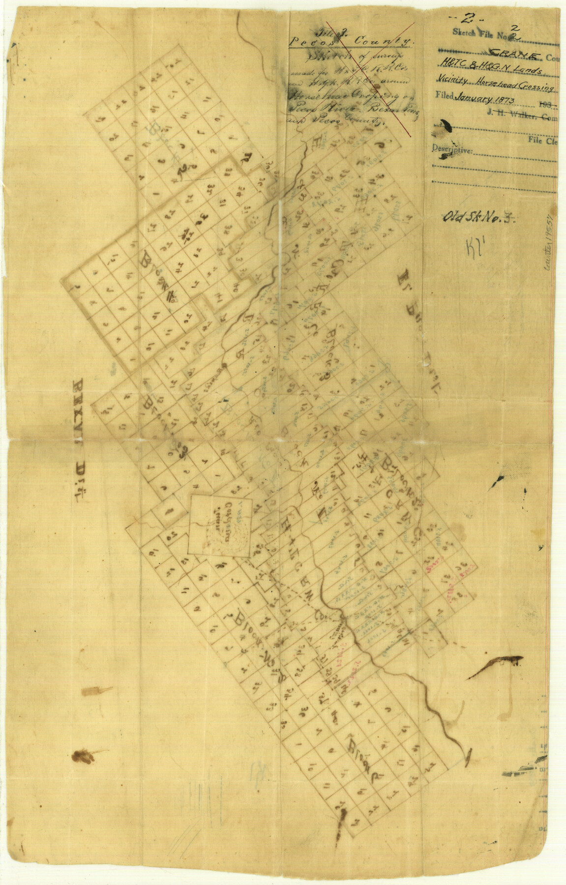
Crane County Sketch File 2
[Sketch of H. & T. C. and H. & G. N. lands in the vicinity of Horsehead Crossing]
-
Map/Doc
19557
-
Collection
General Map Collection
-
Object Dates
1873 (Creation Date)
-
Counties
Crane Pecos
-
Subjects
Surveying Sketch File
-
Height x Width
17.5 x 11.2 inches
44.5 x 28.5 cm
-
Medium
paper, manuscript
-
Features
Rio Pecos
[Horsehead Crossing]
Part of: General Map Collection
Lamar [County]
![3787, Lamar [County], General Map Collection](https://historictexasmaps.com/wmedia_w700/maps/3787.tif.jpg)
Print $40.00
- Digital $50.00
Lamar [County]
1889
Size 48.2 x 35.7 inches
Map/Doc 3787
Dawson County Rolled Sketch 13

Print $20.00
- Digital $50.00
Dawson County Rolled Sketch 13
1951
Size 18.9 x 25.4 inches
Map/Doc 5696
Panola County Working Sketch 23

Print $20.00
- Digital $50.00
Panola County Working Sketch 23
1951
Map/Doc 71432
Mason County Sketch File 6

Print $4.00
- Digital $50.00
Mason County Sketch File 6
1875
Size 8.8 x 14.5 inches
Map/Doc 30687
Flight Mission No. CRC-2R, Frame 1, Chambers County

Print $20.00
- Digital $50.00
Flight Mission No. CRC-2R, Frame 1, Chambers County
1956
Size 18.7 x 22.5 inches
Map/Doc 84720
Flight Mission No. DCL-5C, Frame 50, Kenedy County

Print $20.00
- Digital $50.00
Flight Mission No. DCL-5C, Frame 50, Kenedy County
1943
Size 18.6 x 22.4 inches
Map/Doc 85846
Hardeman County Sketch File 2

Print $6.00
- Digital $50.00
Hardeman County Sketch File 2
1879
Size 9.0 x 7.7 inches
Map/Doc 24984
Hopkins County Sketch File 26

Print $4.00
- Digital $50.00
Hopkins County Sketch File 26
Size 8.4 x 6.1 inches
Map/Doc 26736
Morris County Rolled Sketch 2A

Print $20.00
- Digital $50.00
Morris County Rolled Sketch 2A
Size 24.3 x 18.7 inches
Map/Doc 10675
Carta Esferica que comprehende las costas del Seno Mexicano construida de orden del rey en el deposito hidrografico de marina: Por disposicion del Exmo. Señor Don Juan de Langara, Secretario de Estado y del Despacho Universal de ella. Año de 1799.

Print $20.00
- Digital $50.00
Carta Esferica que comprehende las costas del Seno Mexicano construida de orden del rey en el deposito hidrografico de marina: Por disposicion del Exmo. Señor Don Juan de Langara, Secretario de Estado y del Despacho Universal de ella. Año de 1799.
1799
Size 25.9 x 37.3 inches
Map/Doc 95367
Schleicher County Rolled Sketch 10

Print $20.00
- Digital $50.00
Schleicher County Rolled Sketch 10
Size 30.1 x 25.8 inches
Map/Doc 7753
Texas Intracoastal Waterway - Laguna Madre - Rincon de San Jose to Chubby Island

Print $20.00
- Digital $50.00
Texas Intracoastal Waterway - Laguna Madre - Rincon de San Jose to Chubby Island
1961
Size 38.7 x 27.5 inches
Map/Doc 73515
You may also like
[Surveys along the Salado and Lampasas Rivers and Saltillo Creek]
![362, [Surveys along the Salado and Lampasas Rivers and Saltillo Creek], General Map Collection](https://historictexasmaps.com/wmedia_w700/maps/362.tif.jpg)
Print $2.00
- Digital $50.00
[Surveys along the Salado and Lampasas Rivers and Saltillo Creek]
1845
Size 13.1 x 7.8 inches
Map/Doc 362
[Sections 302-313 and sections south of Blocks D and AX]
![92017, [Sections 302-313 and sections south of Blocks D and AX], Twichell Survey Records](https://historictexasmaps.com/wmedia_w700/maps/92017-1.tif.jpg)
Print $20.00
- Digital $50.00
[Sections 302-313 and sections south of Blocks D and AX]
Size 17.5 x 35.6 inches
Map/Doc 92017
Lampasas County Sketch File 14

Print $6.00
- Digital $50.00
Lampasas County Sketch File 14
Size 16.2 x 10.5 inches
Map/Doc 29426
Map of Rains County

Print $20.00
- Digital $50.00
Map of Rains County
1873
Size 12.0 x 12.4 inches
Map/Doc 4619
[E. T. Ry. Blk. 1]
![89795, [E. T. Ry. Blk. 1], Twichell Survey Records](https://historictexasmaps.com/wmedia_w700/maps/89795-1.tif.jpg)
Print $40.00
- Digital $50.00
[E. T. Ry. Blk. 1]
Size 40.6 x 51.2 inches
Map/Doc 89795
Purchase Area Map, Ropesville Rural Communities, Hockley County, Texas

Print $40.00
- Digital $50.00
Purchase Area Map, Ropesville Rural Communities, Hockley County, Texas
1937
Size 52.9 x 29.3 inches
Map/Doc 89681
Cherokee County Boundary File 3

Print $34.00
- Digital $50.00
Cherokee County Boundary File 3
Size 11.2 x 8.8 inches
Map/Doc 51285
Castro County Working Sketch 6

Print $20.00
- Digital $50.00
Castro County Working Sketch 6
1975
Size 28.4 x 26.4 inches
Map/Doc 67901
Gregg County Working Sketch Graphic Index

Print $20.00
- Digital $50.00
Gregg County Working Sketch Graphic Index
1933
Size 32.4 x 29.5 inches
Map/Doc 76559
Cass County Working Sketch 14

Print $20.00
- Digital $50.00
Cass County Working Sketch 14
1956
Size 36.7 x 26.4 inches
Map/Doc 67917
Presidio County Rolled Sketch 71

Print $20.00
- Digital $50.00
Presidio County Rolled Sketch 71
1941
Size 31.7 x 42.9 inches
Map/Doc 7361
[Littlefield & White Survey, Kimble County, Texas]
![570, [Littlefield & White Survey, Kimble County, Texas], Maddox Collection](https://historictexasmaps.com/wmedia_w700/maps/0570.tif.jpg)
Print $20.00
- Digital $50.00
[Littlefield & White Survey, Kimble County, Texas]
Size 18.6 x 14.2 inches
Map/Doc 570