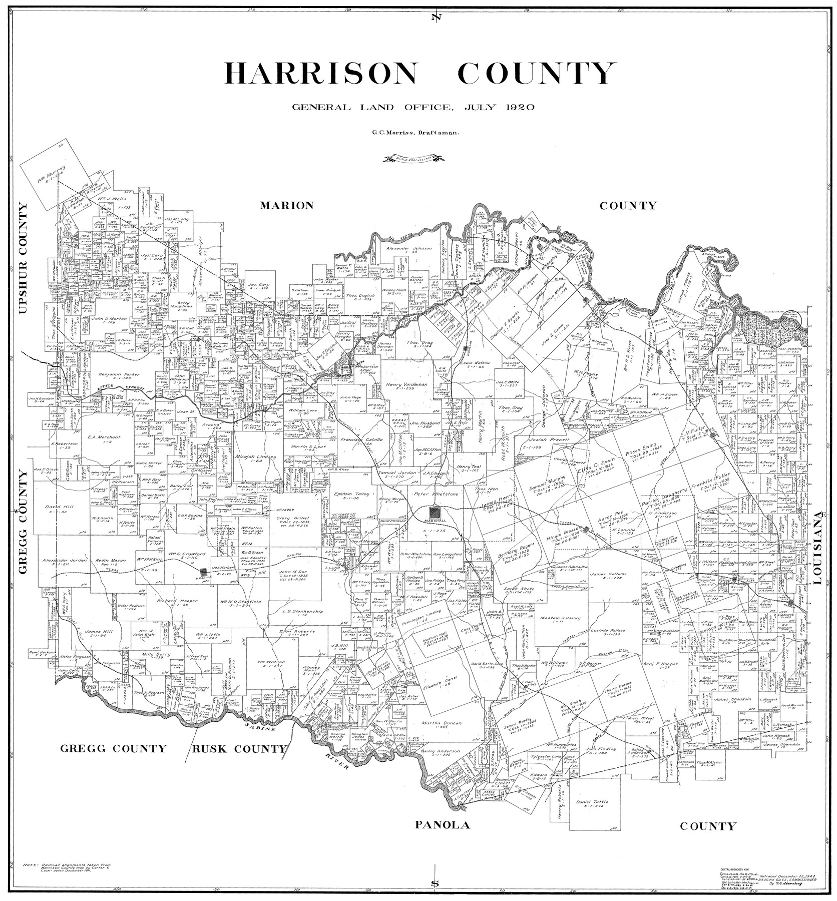
Harrison County
-
Map/Doc
77305
-
Collection
General Map Collection
-
Object Dates
1920 (Creation Date)
-
People and Organizations
G.C. Morriss (Draftsman)
-
Counties
Harrison
-
Subjects
County
-
Height x Width
43.0 x 40.0 inches
109.2 x 101.6 cm
Part of: General Map Collection
Flight Mission No. DIX-6P, Frame 196, Aransas County

Print $20.00
- Digital $50.00
Flight Mission No. DIX-6P, Frame 196, Aransas County
1956
Size 18.9 x 22.6 inches
Map/Doc 83858
Denton County Sketch File 17

Print $4.00
- Digital $50.00
Denton County Sketch File 17
1857
Size 12.7 x 8.4 inches
Map/Doc 20729
Crockett County Working Sketch 84

Print $40.00
- Digital $50.00
Crockett County Working Sketch 84
1976
Size 49.4 x 26.2 inches
Map/Doc 68417
Map of the Houston and Great Northern R.R. from Trinity River to Palestine

Print $40.00
- Digital $50.00
Map of the Houston and Great Northern R.R. from Trinity River to Palestine
1872
Size 30.3 x 119.9 inches
Map/Doc 64549
Flight Mission No. DAG-23K, Frame 61, Matagorda County

Print $20.00
- Digital $50.00
Flight Mission No. DAG-23K, Frame 61, Matagorda County
1953
Size 16.0 x 15.7 inches
Map/Doc 86488
Topographical Map of the Rio Grande, Sheet No. 2

Print $20.00
- Digital $50.00
Topographical Map of the Rio Grande, Sheet No. 2
1912
Map/Doc 89526
Lynn County Working Sketch 4

Print $20.00
- Digital $50.00
Lynn County Working Sketch 4
1965
Size 33.5 x 33.8 inches
Map/Doc 70674
Gulf of Mexico

Print $20.00
- Digital $50.00
Gulf of Mexico
1908
Size 18.2 x 27.9 inches
Map/Doc 72659
Van Zandt County Sketch File 2

Print $9.00
- Digital $50.00
Van Zandt County Sketch File 2
1852
Size 12.9 x 4.9 inches
Map/Doc 39359
Denton County Sketch File 33

Print $4.00
- Digital $50.00
Denton County Sketch File 33
Size 8.2 x 12.4 inches
Map/Doc 20760
Cottle County Sketch File 6c

Print $8.00
- Digital $50.00
Cottle County Sketch File 6c
Size 14.2 x 8.6 inches
Map/Doc 19480
[St. L. S-W. Ry. Of Texas Map of Lufkin Branch in Cherokee County Texas]
![64022, [St. L. S-W. Ry. Of Texas Map of Lufkin Branch in Cherokee County Texas], General Map Collection](https://historictexasmaps.com/wmedia_w700/maps/64022.tif.jpg)
Print $40.00
- Digital $50.00
[St. L. S-W. Ry. Of Texas Map of Lufkin Branch in Cherokee County Texas]
1912
Size 23.1 x 122.7 inches
Map/Doc 64022
You may also like
Calhoun County Rolled Sketch 23

Print $40.00
- Digital $50.00
Calhoun County Rolled Sketch 23
1967
Size 31.1 x 67.0 inches
Map/Doc 8553
Potter County Rolled Sketch 10

Print $20.00
- Digital $50.00
Potter County Rolled Sketch 10
1963
Size 31.8 x 43.3 inches
Map/Doc 7323
Jim Hogg County Rolled Sketch 8

Print $20.00
- Digital $50.00
Jim Hogg County Rolled Sketch 8
1956
Size 32.1 x 38.2 inches
Map/Doc 9323
Presidio County Working Sketch 66

Print $20.00
- Digital $50.00
Presidio County Working Sketch 66
1960
Size 44.9 x 22.8 inches
Map/Doc 71743
Pecos County Working Sketch 58

Print $20.00
- Digital $50.00
Pecos County Working Sketch 58
1949
Size 20.5 x 22.0 inches
Map/Doc 71530
[Blocks A-6, A-7, G, C-35, C-34]
![92816, [Blocks A-6, A-7, G, C-35, C-34], Twichell Survey Records](https://historictexasmaps.com/wmedia_w700/maps/92816-1.tif.jpg)
Print $20.00
- Digital $50.00
[Blocks A-6, A-7, G, C-35, C-34]
Size 43.5 x 20.2 inches
Map/Doc 92816
Kimble County Sketch File 13

Print $24.00
- Digital $50.00
Kimble County Sketch File 13
1885
Size 14.1 x 8.6 inches
Map/Doc 28937
[F. W. & D. C. Ry. Co. Alignment and Right of Way Map, Clay County]
![64740, [F. W. & D. C. Ry. Co. Alignment and Right of Way Map, Clay County], General Map Collection](https://historictexasmaps.com/wmedia_w700/maps/64740-GC.tif.jpg)
Print $20.00
- Digital $50.00
[F. W. & D. C. Ry. Co. Alignment and Right of Way Map, Clay County]
1927
Size 18.7 x 11.8 inches
Map/Doc 64740
Reeves County Sketch File 22

Print $4.00
- Digital $50.00
Reeves County Sketch File 22
Size 14.3 x 8.7 inches
Map/Doc 35220
Atascosa County Boundary File 7

Print $20.00
- Digital $50.00
Atascosa County Boundary File 7
Size 8.2 x 10.1 inches
Map/Doc 50213
Map of University Land being a part of Block L, El Paso County, Texas

Print $20.00
- Digital $50.00
Map of University Land being a part of Block L, El Paso County, Texas
1945
Size 26.1 x 25.8 inches
Map/Doc 2423
Map of Atascosa County, Texas

Print $20.00
- Digital $50.00
Map of Atascosa County, Texas
1916
Size 30.0 x 28.6 inches
Map/Doc 9006