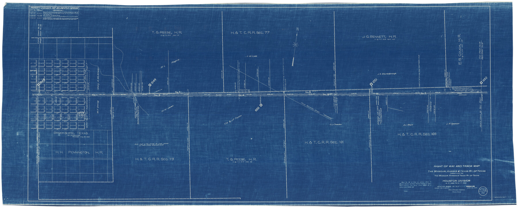
Right of Way and Track Map, the Missouri, Kansas & Texas Ry. Of Texas operated by the Missouri, Kansas & Texas Ry. Of Texas, Houston Division
M.P. 1048 to M.P. 1052, Station 20689+49 to Station 20900+69
Z-2-176
-
Map/Doc
64567
-
Collection
General Map Collection
-
Object Dates
6/30/1918 (Creation Date)
9/24/1945 (File Date)
-
Counties
Waller
-
Subjects
Railroads
-
Height x Width
25.5 x 61.9 inches
64.8 x 157.2 cm
-
Medium
blueprint/diazo
-
Scale
1" = 400 feet
-
Comments
See counter nos. 64565 through 64566 and 64785 through 64786 for other sheets of the map.
-
Features
MK&T
Brookshire
[Railroad line] to Taylor
Part of: General Map Collection
PSL Field Notes for Block C24 in Loving and Winkler Counties, and Blocks C25, C26, and C27 in Loving County

PSL Field Notes for Block C24 in Loving and Winkler Counties, and Blocks C25, C26, and C27 in Loving County
Map/Doc 81680
Martin County Sketch File 12

Print $20.00
- Digital $50.00
Martin County Sketch File 12
1937
Size 22.9 x 19.5 inches
Map/Doc 12030
Calhoun County NRC Article 33.136 Sketch 15

Print $46.00
Calhoun County NRC Article 33.136 Sketch 15
2025
Map/Doc 97428
Flight Mission No. DIX-3P, Frame 137, Aransas County

Print $20.00
- Digital $50.00
Flight Mission No. DIX-3P, Frame 137, Aransas County
1956
Size 17.8 x 18.4 inches
Map/Doc 83767
Coryell County Working Sketch 10

Print $20.00
- Digital $50.00
Coryell County Working Sketch 10
1949
Size 36.7 x 37.0 inches
Map/Doc 68217
Palo Pinto County Working Sketch 5

Print $40.00
- Digital $50.00
Palo Pinto County Working Sketch 5
1920
Map/Doc 71388

Galveston Bay Oil Area, Galveston, Harris, Chambers and Brazoria Cos.

Print $40.00
- Digital $50.00
Galveston Bay Oil Area, Galveston, Harris, Chambers and Brazoria Cos.
1927
Size 52.9 x 40.8 inches
Map/Doc 2938
Hispaniae Novae Sivae Magnae Recens et Vera Descriptio 1579

Print $20.00
- Digital $50.00
Hispaniae Novae Sivae Magnae Recens et Vera Descriptio 1579
1581
Size 17.9 x 23.0 inches
Map/Doc 94036
Flight Mission No. DQN-1K, Frame 33, Calhoun County

Print $20.00
- Digital $50.00
Flight Mission No. DQN-1K, Frame 33, Calhoun County
1953
Size 15.5 x 15.5 inches
Map/Doc 84138
Brooks County Sketch File 6

Print $12.00
- Digital $50.00
Brooks County Sketch File 6
1941
Size 13.2 x 8.3 inches
Map/Doc 16560
Dallam County Sketch File 2

Print $260.00
- Digital $50.00
Dallam County Sketch File 2
1886
Size 29.9 x 17.4 inches
Map/Doc 11278
You may also like
Mason County Working Sketch 8

Print $20.00
- Digital $50.00
Mason County Working Sketch 8
1946
Size 22.9 x 32.3 inches
Map/Doc 70844
Uvalde County Sketch File 4

Print $22.00
- Digital $50.00
Uvalde County Sketch File 4
1879
Size 12.8 x 8.3 inches
Map/Doc 38951
Knox County Rolled Sketch 14

Print $40.00
- Digital $50.00
Knox County Rolled Sketch 14
1892
Size 21.8 x 54.9 inches
Map/Doc 10666
Lee County Working Sketch 15

Print $20.00
- Digital $50.00
Lee County Working Sketch 15
1981
Size 18.4 x 14.0 inches
Map/Doc 70394
Newton County Sketch File 4c

Print $4.00
- Digital $50.00
Newton County Sketch File 4c
Size 7.4 x 8.2 inches
Map/Doc 32366
Panola County Sketch File 30

Print $4.00
- Digital $50.00
Panola County Sketch File 30
1944
Size 2.8 x 8.9 inches
Map/Doc 33505
Colorado County Rolled Sketch 5

Print $20.00
- Digital $50.00
Colorado County Rolled Sketch 5
1965
Size 37.9 x 35.9 inches
Map/Doc 8644
Galveston to Rio Grande

Print $20.00
- Digital $50.00
Galveston to Rio Grande
1946
Size 44.6 x 36.6 inches
Map/Doc 69952
[Garza, Blanco, Uvalde, and Crosby County School Lands]
![91197, [Garza, Blanco, Uvalde, and Crosby County School Lands], Twichell Survey Records](https://historictexasmaps.com/wmedia_w700/maps/91197-1.tif.jpg)
Print $20.00
- Digital $50.00
[Garza, Blanco, Uvalde, and Crosby County School Lands]
1913
Size 14.7 x 16.6 inches
Map/Doc 91197
[Aerial photograph from Carancahua Bend of Caney Creek to Cedar Lake]
![78641, [Aerial photograph from Carancahua Bend of Caney Creek to Cedar Lake], General Map Collection](https://historictexasmaps.com/wmedia_w700/maps/78641.tif.jpg)
Print $20.00
- Digital $50.00
[Aerial photograph from Carancahua Bend of Caney Creek to Cedar Lake]
1991
Size 24.5 x 31.9 inches
Map/Doc 78641
Calhoun County Rolled Sketch 20

Print $20.00
- Digital $50.00
Calhoun County Rolled Sketch 20
1959
Size 36.9 x 20.7 inches
Map/Doc 5372
Chambers County Sketch File 21

Print $20.00
- Digital $50.00
Chambers County Sketch File 21
Size 29.3 x 32.8 inches
Map/Doc 10331