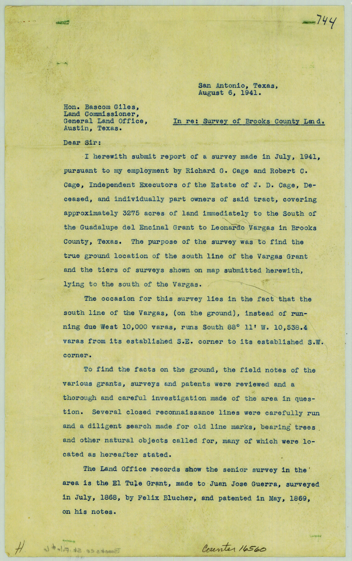
Brooks County Sketch File 6
[Surveyor's statement regarding lands to the south of Guadalupe del Encinal grant to Leonardo Vargas]
-
Map/Doc
16560
-
Collection
General Map Collection
-
Object Dates
1941/8/6 (Creation Date)
1941/8/7 (File Date)
1941 (Survey Date)
-
People and Organizations
Chas. R. Hedke (Surveyor/Engineer)
-
Counties
Brooks
-
Subjects
Surveying Sketch File
-
Height x Width
13.2 x 8.3 inches
33.5 x 21.1 cm
-
Medium
paper, print
-
Comments
See Brooks County Rolled Sketch 16 (5341) and Brooks County Rolled Sketch 17 (8532)
Related maps
Brooks County Rolled Sketch 16

Print $20.00
- Digital $50.00
Brooks County Rolled Sketch 16
1941
Size 18.0 x 18.8 inches
Map/Doc 5341
Brooks County Rolled Sketch 17

Print $20.00
- Digital $50.00
Brooks County Rolled Sketch 17
1941
Size 30.8 x 36.5 inches
Map/Doc 8532
Part of: General Map Collection
Edwards County Sketch File 12b

Print $4.00
- Digital $50.00
Edwards County Sketch File 12b
Size 14.4 x 8.8 inches
Map/Doc 21698
Cooke County Working Sketch 18

Print $20.00
- Digital $50.00
Cooke County Working Sketch 18
1952
Size 23.5 x 19.6 inches
Map/Doc 68255
Aransas County Sketch File 29

Print $24.00
- Digital $50.00
Aransas County Sketch File 29
Size 7.8 x 8.1 inches
Map/Doc 13234
Lampasas County

Print $20.00
- Digital $50.00
Lampasas County
1972
Size 33.2 x 41.9 inches
Map/Doc 77347
Morris County Rolled Sketch 2A

Print $20.00
- Digital $50.00
Morris County Rolled Sketch 2A
Size 36.7 x 25.1 inches
Map/Doc 10259
Brewster County Working Sketch 86

Print $20.00
- Digital $50.00
Brewster County Working Sketch 86
1973
Size 27.6 x 27.7 inches
Map/Doc 67686
Hays County Sketch File 31

Print $6.00
- Digital $50.00
Hays County Sketch File 31
1943
Size 14.4 x 8.8 inches
Map/Doc 26261
Flight Mission No. BQR-4K, Frame 62, Brazoria County

Print $20.00
- Digital $50.00
Flight Mission No. BQR-4K, Frame 62, Brazoria County
1952
Size 18.9 x 22.5 inches
Map/Doc 83995
Map of Texas compiled from surveys recorded in the Land Office of Texas and other official surveys

Print $20.00
- Digital $50.00
Map of Texas compiled from surveys recorded in the Land Office of Texas and other official surveys
1841
Size 24.6 x 24.2 inches
Map/Doc 96435
Map of Runnels County

Print $20.00
- Digital $50.00
Map of Runnels County
1898
Size 43.2 x 36.9 inches
Map/Doc 16803
Flight Mission No. BRA-16M, Frame 123, Jefferson County

Print $20.00
- Digital $50.00
Flight Mission No. BRA-16M, Frame 123, Jefferson County
1953
Size 18.6 x 22.5 inches
Map/Doc 85733
Map No. 8-A, Calhoun Co. - Revision of the East portion of Espiritu Santo Bay Tracts

Print $5.00
- Digital $50.00
Map No. 8-A, Calhoun Co. - Revision of the East portion of Espiritu Santo Bay Tracts
1978
Size 21.2 x 28.0 inches
Map/Doc 2498
You may also like
Sketch in Cochran County, Texas

Print $20.00
- Digital $50.00
Sketch in Cochran County, Texas
1949
Size 21.8 x 21.0 inches
Map/Doc 92495
[Coordinates for Block H, Sections 1 and 2 and Block C41, Section 4]
![92566, [Coordinates for Block H, Sections 1 and 2 and Block C41, Section 4], Twichell Survey Records](https://historictexasmaps.com/wmedia_w700/maps/92566-1.tif.jpg)
Print $3.00
- Digital $50.00
[Coordinates for Block H, Sections 1 and 2 and Block C41, Section 4]
1940
Size 11.4 x 17.4 inches
Map/Doc 92566
Flight Mission No. BRA-6M, Frame 148, Jefferson County

Print $20.00
- Digital $50.00
Flight Mission No. BRA-6M, Frame 148, Jefferson County
1953
Size 18.5 x 22.4 inches
Map/Doc 85449
Sutton County Sketch File 33B

Print $20.00
- Digital $50.00
Sutton County Sketch File 33B
1934
Size 17.1 x 29.5 inches
Map/Doc 12386
Map of the Missouri Pacific and St. Louis, Iron Mountain and Southern Railways and Connections

Print $20.00
- Digital $50.00
Map of the Missouri Pacific and St. Louis, Iron Mountain and Southern Railways and Connections
1893
Size 17.7 x 31.6 inches
Map/Doc 95789
Chambers County Sketch File 7

Print $4.00
- Digital $50.00
Chambers County Sketch File 7
1867
Size 10.2 x 8.4 inches
Map/Doc 17542
Jackson County Working Sketch 1

Print $20.00
- Digital $50.00
Jackson County Working Sketch 1
1911
Size 20.6 x 13.0 inches
Map/Doc 66449
The Republic County of Houston. February 2, 1842

Print $20.00
The Republic County of Houston. February 2, 1842
2020
Size 19.7 x 21.8 inches
Map/Doc 96181
Calcasieu Pass to Sabine Pass

Print $20.00
- Digital $50.00
Calcasieu Pass to Sabine Pass
1946
Size 44.7 x 35.7 inches
Map/Doc 69806
Red River County Working Sketch 20

Print $20.00
- Digital $50.00
Red River County Working Sketch 20
1955
Size 26.2 x 25.9 inches
Map/Doc 72003
Guadalupe River, Watershed [of the Guadalupe River]
![65059, Guadalupe River, Watershed [of the Guadalupe River], General Map Collection](https://historictexasmaps.com/wmedia_w700/maps/65059-GC.tif.jpg)
Print $6.00
- Digital $50.00
Guadalupe River, Watershed [of the Guadalupe River]
1925
Size 30.1 x 33.4 inches
Map/Doc 65059
[Right of Way & Track Map, The Texas & Pacific Ry. Co. Main Line]
![64660, [Right of Way & Track Map, The Texas & Pacific Ry. Co. Main Line], General Map Collection](https://historictexasmaps.com/wmedia_w700/maps/64660.tif.jpg)
Print $20.00
- Digital $50.00
[Right of Way & Track Map, The Texas & Pacific Ry. Co. Main Line]
Size 11.0 x 18.6 inches
Map/Doc 64660