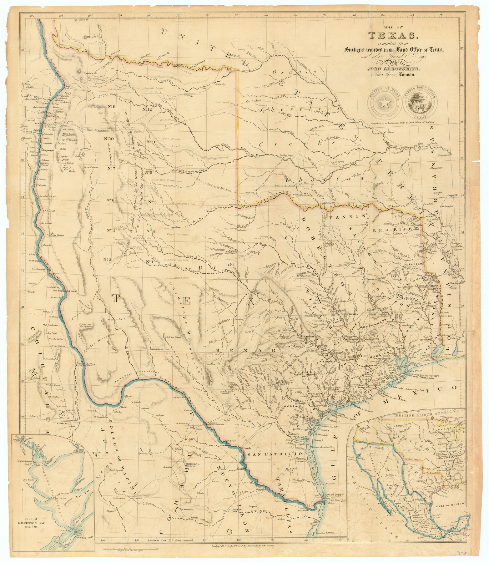
Map of Texas compiled from surveys recorded in the Land Office of Texas and other official surveys
-
Map/Doc
96435
-
Collection
General Map Collection
-
Object Dates
4/17/1841 (Creation Date)
-
People and Organizations
John Arrowsmith (Cartographer)
-
Subjects
Republic of Texas
-
Height x Width
24.6 x 24.2 inches
62.5 x 61.5 cm
-
Medium
paper, etching/engraving/lithograph
-
Comments
Map originally bound in William Kennedy's "The Rise, Progress, and Prospects of the Republic of Texas"
Part of: General Map Collection
San Patricio County NRC Article 33.136 Location Key Sheet

Print $20.00
- Digital $50.00
San Patricio County NRC Article 33.136 Location Key Sheet
1975
Size 27.0 x 23.0 inches
Map/Doc 87914
El Paso County Rolled Sketch 64

Print $246.00
- Digital $50.00
El Paso County Rolled Sketch 64
1993
Size 11.3 x 8.7 inches
Map/Doc 41531
Dawson County Sketch File 10

Print $4.00
- Digital $50.00
Dawson County Sketch File 10
1927
Size 11.4 x 8.8 inches
Map/Doc 20544
Brewster County Working Sketch 50

Print $40.00
- Digital $50.00
Brewster County Working Sketch 50
1950
Size 31.5 x 48.4 inches
Map/Doc 67584
Jack County Sketch File 3

Print $6.00
- Digital $50.00
Jack County Sketch File 3
1857
Size 10.6 x 16.5 inches
Map/Doc 27504
Real County Working Sketch 32

Print $20.00
- Digital $50.00
Real County Working Sketch 32
1948
Size 15.6 x 19.6 inches
Map/Doc 71924
Harris County Rolled Sketch 45

Print $20.00
- Digital $50.00
Harris County Rolled Sketch 45
Size 20.2 x 21.0 inches
Map/Doc 6103
Flight Mission No. DAG-24K, Frame 149, Matagorda County

Print $20.00
- Digital $50.00
Flight Mission No. DAG-24K, Frame 149, Matagorda County
1953
Size 18.4 x 16.2 inches
Map/Doc 86563
Jim Wells County Working Sketch 1

Print $20.00
- Digital $50.00
Jim Wells County Working Sketch 1
Size 17.2 x 22.2 inches
Map/Doc 66599
Flight Mission No. DQO-8K, Frame 43, Galveston County

Print $20.00
- Digital $50.00
Flight Mission No. DQO-8K, Frame 43, Galveston County
1952
Size 18.6 x 22.3 inches
Map/Doc 85150
El Paso County Boundary File 14a

Print $7.00
- Digital $50.00
El Paso County Boundary File 14a
Size 11.1 x 8.7 inches
Map/Doc 53183
Flight Mission No. DCL-6C, Frame 22, Kenedy County

Print $20.00
- Digital $50.00
Flight Mission No. DCL-6C, Frame 22, Kenedy County
1943
Size 18.6 x 22.3 inches
Map/Doc 85879
You may also like


Galveston County NRC Article 33.136 Sketch 76

Print $26.00
- Digital $50.00
Galveston County NRC Article 33.136 Sketch 76
2014
Size 24.5 x 36.5 inches
Map/Doc 95125
Presidio County Working Sketch 51

Print $20.00
- Digital $50.00
Presidio County Working Sketch 51
1953
Size 33.4 x 43.1 inches
Map/Doc 71728
Maps of Gulf Intracoastal Waterway, Texas - Sabine River to the Rio Grande and connecting waterways including ship channels

Print $20.00
- Digital $50.00
Maps of Gulf Intracoastal Waterway, Texas - Sabine River to the Rio Grande and connecting waterways including ship channels
1966
Size 14.6 x 22.3 inches
Map/Doc 61965
West Half of Sabine Lake, Jefferson County, showing Subdivision for Mineral Development; do not use; see Map 25a

Print $20.00
- Digital $50.00
West Half of Sabine Lake, Jefferson County, showing Subdivision for Mineral Development; do not use; see Map 25a
1956
Size 38.2 x 28.4 inches
Map/Doc 1930
Hood County Sketch File 20

Print $4.00
- Digital $50.00
Hood County Sketch File 20
1873
Size 6.8 x 6.9 inches
Map/Doc 26607
Map of the Straits of Florida and Gulf of Mexico

Print $20.00
- Digital $50.00
Map of the Straits of Florida and Gulf of Mexico
1851
Size 18.3 x 27.5 inches
Map/Doc 72673
Jeff Davis County Rolled Sketch 5

Print $40.00
- Digital $50.00
Jeff Davis County Rolled Sketch 5
Size 34.7 x 48.6 inches
Map/Doc 9262
St. Marks to Galveston - Sheet II

Print $20.00
- Digital $50.00
St. Marks to Galveston - Sheet II
1846
Size 26.5 x 40.5 inches
Map/Doc 97397
Jeff Davis County Sketch File 8

Print $20.00
- Digital $50.00
Jeff Davis County Sketch File 8
1889
Size 19.5 x 28.5 inches
Map/Doc 11857
Travis County State Real Property Sketch 2

Print $20.00
- Digital $50.00
Travis County State Real Property Sketch 2
1986
Size 34.0 x 35.5 inches
Map/Doc 61693