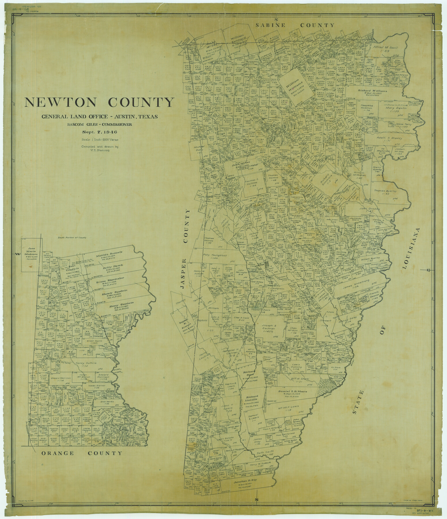
Newton County
RM-4-176
-
Map/Doc
66953
-
Collection
General Map Collection
-
Object Dates
1946/9/7 (Creation Date)
-
People and Organizations
Texas General Land Office (Publisher)
Bascom Giles (GLO Commissioner)
Victor E. Sterzing (Draftsman)
Victor E. Sterzing (Compiler)
-
Counties
Newton
-
Subjects
County
-
Height x Width
48.7 x 41.9 inches
123.7 x 106.4 cm
-
Comments
Traced August 18, 1947 by Gladys Adams.
Part of: General Map Collection
Pecos County Rolled Sketch 78

Print $40.00
- Digital $50.00
Pecos County Rolled Sketch 78
1930
Size 52.6 x 44.1 inches
Map/Doc 9705
Comanche County Working Sketch 6

Print $20.00
- Digital $50.00
Comanche County Working Sketch 6
1935
Size 26.4 x 17.8 inches
Map/Doc 68140
Polk County Sketch File 44

Print $193.00
- Digital $50.00
Polk County Sketch File 44
1958
Size 9.4 x 11.0 inches
Map/Doc 34297
Edwards County Rolled Sketch J

Print $83.00
- Digital $50.00
Edwards County Rolled Sketch J
1918
Size 23.6 x 30.3 inches
Map/Doc 5818
Clay County Working Sketch 10

Print $20.00
- Digital $50.00
Clay County Working Sketch 10
1941
Size 35.5 x 26.5 inches
Map/Doc 68033
Chambers County Rolled Sketch 8

Print $20.00
- Digital $50.00
Chambers County Rolled Sketch 8
Size 39.8 x 30.5 inches
Map/Doc 8612
Reagan County Rolled Sketch 9

Print $20.00
- Digital $50.00
Reagan County Rolled Sketch 9
1937
Size 29.7 x 30.9 inches
Map/Doc 7437
[Galveston, Harrisburg & San Antonio Railway]
![64405, [Galveston, Harrisburg & San Antonio Railway], General Map Collection](https://historictexasmaps.com/wmedia_w700/maps/64405.tif.jpg)
Print $20.00
- Digital $50.00
[Galveston, Harrisburg & San Antonio Railway]
1892
Size 13.5 x 33.6 inches
Map/Doc 64405
Flight Mission No. CGI-1N, Frame 185, Cameron County

Print $20.00
- Digital $50.00
Flight Mission No. CGI-1N, Frame 185, Cameron County
1955
Size 18.6 x 22.2 inches
Map/Doc 84520
Parker County Working Sketch 17

Print $20.00
- Digital $50.00
Parker County Working Sketch 17
1996
Map/Doc 71467
Coast Chart No. 209 - Aransas Pass, Aransas and Copano Bays, Texas

Print $20.00
- Digital $50.00
Coast Chart No. 209 - Aransas Pass, Aransas and Copano Bays, Texas
1889
Size 31.2 x 24.9 inches
Map/Doc 73429
Leon County Working Sketch Graphic Index

Print $20.00
- Digital $50.00
Leon County Working Sketch Graphic Index
1977
Size 46.8 x 41.5 inches
Map/Doc 76618
You may also like
Hemphill County Working Sketch 38

Print $20.00
- Digital $50.00
Hemphill County Working Sketch 38
1982
Size 29.9 x 27.8 inches
Map/Doc 66133
Howard County Rolled Sketch 12A

Print $20.00
- Digital $50.00
Howard County Rolled Sketch 12A
1948
Size 23.3 x 13.9 inches
Map/Doc 6244
Crockett County Rolled Sketch 99

Print $20.00
- Digital $50.00
Crockett County Rolled Sketch 99
Size 37.2 x 38.2 inches
Map/Doc 95401
Map of the United States, the British Provinces, Mexico &c. Showing the Routes of the U.S. Mail Steam Packets to California and a Plan of the Gold Region

Print $20.00
- Digital $50.00
Map of the United States, the British Provinces, Mexico &c. Showing the Routes of the U.S. Mail Steam Packets to California and a Plan of the Gold Region
1849
Size 19.6 x 26.6 inches
Map/Doc 95695
Knox County Sketch File 9

Print $4.00
- Digital $50.00
Knox County Sketch File 9
1889
Size 11.1 x 8.8 inches
Map/Doc 29221
Schleicher County Sketch File 45

Print $22.00
- Digital $50.00
Schleicher County Sketch File 45
1972
Size 4.2 x 8.8 inches
Map/Doc 36552
[Blocks O, H, B, S, RG, and 11]
![91333, [Blocks O, H, B, S, RG, and 11], Twichell Survey Records](https://historictexasmaps.com/wmedia_w700/maps/91333-1.tif.jpg)
Print $20.00
- Digital $50.00
[Blocks O, H, B, S, RG, and 11]
1921
Size 24.9 x 15.3 inches
Map/Doc 91333
Flight Mission No. CUG-1P, Frame 20, Kleberg County

Print $20.00
- Digital $50.00
Flight Mission No. CUG-1P, Frame 20, Kleberg County
1956
Size 18.6 x 22.4 inches
Map/Doc 86110
Concho County Working Sketch 15

Print $20.00
- Digital $50.00
Concho County Working Sketch 15
1955
Size 25.2 x 30.8 inches
Map/Doc 68197
Victoria County Rolled Sketch 9

Print $20.00
- Digital $50.00
Victoria County Rolled Sketch 9
Size 24.1 x 36.2 inches
Map/Doc 95399
Cottle County Working Sketch 16

Print $20.00
- Digital $50.00
Cottle County Working Sketch 16
1975
Size 24.5 x 21.6 inches
Map/Doc 68326
[Public School Land Blocks B1 and B7]
![91974, [Public School Land Blocks B1 and B7], Twichell Survey Records](https://historictexasmaps.com/wmedia_w700/maps/91974-1.tif.jpg)
Print $20.00
- Digital $50.00
[Public School Land Blocks B1 and B7]
Size 22.9 x 14.8 inches
Map/Doc 91974