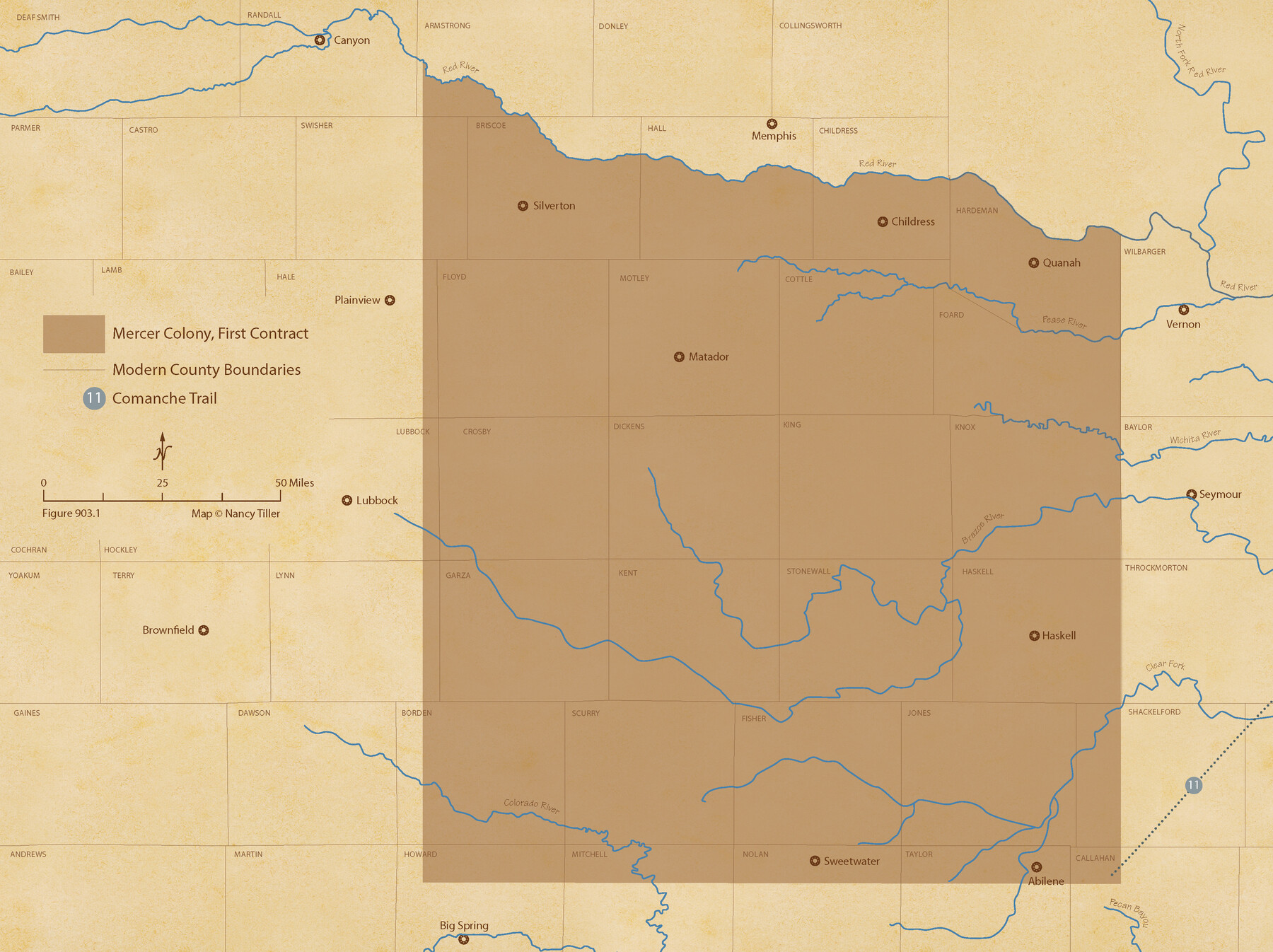
The Mercer Colony. January 20, 1843
Figure No. 903.1 from 'A Boundary Atlas of Texas, 1821-1845' by Jim Tiller
-
Map/Doc
96360
-
Collection
Nancy and Jim Tiller Digital Collection
-
Object Dates
2020/1/1 (Creation Date)
-
People and Organizations
Jim Tiller (Author)
Nancy Tiller (Cartographer)
Gang Gong (GIS Professional)
-
Subjects
Atlas Colony Republic of Texas Texas Boundaries
-
Height x Width
16.2 x 21.7 inches
41.2 x 55.1 cm
-
Medium
digital image
-
Comments
To purchase a digital PDF copy of "A Boundary Atlas of Texas, 1821-1845" see 96437.
Part of: Nancy and Jim Tiller Digital Collection
The Republic County of Matagorda. 1840

Print $20.00
The Republic County of Matagorda. 1840
2020
Size 21.0 x 21.7 inches
Map/Doc 96218
The Land Offices. No. 5, Matagorda, December 22, 1836

Print $20.00
The Land Offices. No. 5, Matagorda, December 22, 1836
2020
Size 12.5 x 21.7 inches
Map/Doc 96418
The Republic County of Harris. Proposed, Late Fall 1837-May 15, 1838

Print $20.00
The Republic County of Harris. Proposed, Late Fall 1837-May 15, 1838
2020
Size 17.7 x 21.7 inches
Map/Doc 96162
The Judicial District/County of Spring Creek. Created, January 21, 1841

Print $20.00
The Judicial District/County of Spring Creek. Created, January 21, 1841
2020
Size 15.7 x 21.7 inches
Map/Doc 96348
From Citizens of Austin County Requesting to be Attached to Washington County, Undated

Print $20.00
From Citizens of Austin County Requesting to be Attached to Washington County, Undated
2020
Size 18.8 x 21.7 inches
Map/Doc 96398
The Republic County of Houston. Created, June 12, 1837

Print $20.00
The Republic County of Houston. Created, June 12, 1837
2020
Size 19.7 x 21.7 inches
Map/Doc 96178
The Republic County of Bexar. November 28, 1839

Print $20.00
The Republic County of Bexar. November 28, 1839
2020
Size 14.8 x 21.1 inches
Map/Doc 96097
From Citizens Living Between the Brazos and Trinity Rivers and Below the Old San Antonio Road in Montgomery and Washington Counties for the Creation of a New County to be Called Travis, Undated

Print $20.00
From Citizens Living Between the Brazos and Trinity Rivers and Below the Old San Antonio Road in Montgomery and Washington Counties for the Creation of a New County to be Called Travis, Undated
2020
Size 21.2 x 21.7 inches
Map/Doc 96401
The Chief Justice County of Victoria. Lands in Conflict with Bexar and Gonzales Counties

Print $20.00
The Chief Justice County of Victoria. Lands in Conflict with Bexar and Gonzales Counties
2020
Size 23.3 x 21.7 inches
Map/Doc 96076
The Chief Justice County of Gonzales. Lands in Conflict with Victoria County

Print $20.00
The Chief Justice County of Gonzales. Lands in Conflict with Victoria County
2020
Size 22.3 x 21.7 inches
Map/Doc 96048
Vehlein and Company Empresario Colony. November 17, 1828

Print $20.00
Vehlein and Company Empresario Colony. November 17, 1828
2020
Size 20.8 x 21.7 inches
Map/Doc 96008
The Judicial District/County of Menard. Created, January 22, 1841

Print $20.00
The Judicial District/County of Menard. Created, January 22, 1841
2020
Size 22.4 x 21.7 inches
Map/Doc 96335
You may also like
Flight Mission No. BRA-16M, Frame 151, Jefferson County

Print $20.00
- Digital $50.00
Flight Mission No. BRA-16M, Frame 151, Jefferson County
1953
Size 18.7 x 22.3 inches
Map/Doc 85757
Sylvan Sanders Map of Gaines County, Texas

Print $40.00
- Digital $50.00
Sylvan Sanders Map of Gaines County, Texas
Size 54.3 x 40.8 inches
Map/Doc 89844

Montgomery County Working Sketch 5

Print $20.00
- Digital $50.00
Montgomery County Working Sketch 5
1932
Size 31.6 x 37.0 inches
Map/Doc 71111

[USGS Topo Quad map of Shafter Sheet, Presidio County]
![91754, [USGS Topo Quad map of Shafter Sheet, Presidio County], Twichell Survey Records](https://historictexasmaps.com/wmedia_w700/maps/91754-1.tif.jpg)
Print $20.00
- Digital $50.00
[USGS Topo Quad map of Shafter Sheet, Presidio County]
1895
Size 16.9 x 20.5 inches
Map/Doc 91754
Cottle County Sketch File 13

Print $20.00
- Digital $50.00
Cottle County Sketch File 13
1904
Size 15.8 x 15.8 inches
Map/Doc 11195
Rains County Boundary File 2

Print $4.00
- Digital $50.00
Rains County Boundary File 2
Size 8.2 x 5.8 inches
Map/Doc 58092
[Right of Way Map, Belton Branch of the M.K.&T. RR.]
![64224, [Right of Way Map, Belton Branch of the M.K.&T. RR.], General Map Collection](https://historictexasmaps.com/wmedia_w700/maps/64224.tif.jpg)
Print $20.00
- Digital $50.00
[Right of Way Map, Belton Branch of the M.K.&T. RR.]
1896
Size 7.1 x 20.6 inches
Map/Doc 64224
McMullen County Sketch File 7

Print $40.00
- Digital $50.00
McMullen County Sketch File 7
1859
Size 19.1 x 11.6 inches
Map/Doc 31347
Starr County Rolled Sketch 24

Print $20.00
- Digital $50.00
Starr County Rolled Sketch 24
1938
Size 37.5 x 26.7 inches
Map/Doc 7808
Burleson County Working Sketch 33

Print $20.00
- Digital $50.00
Burleson County Working Sketch 33
1981
Size 33.9 x 34.8 inches
Map/Doc 67752