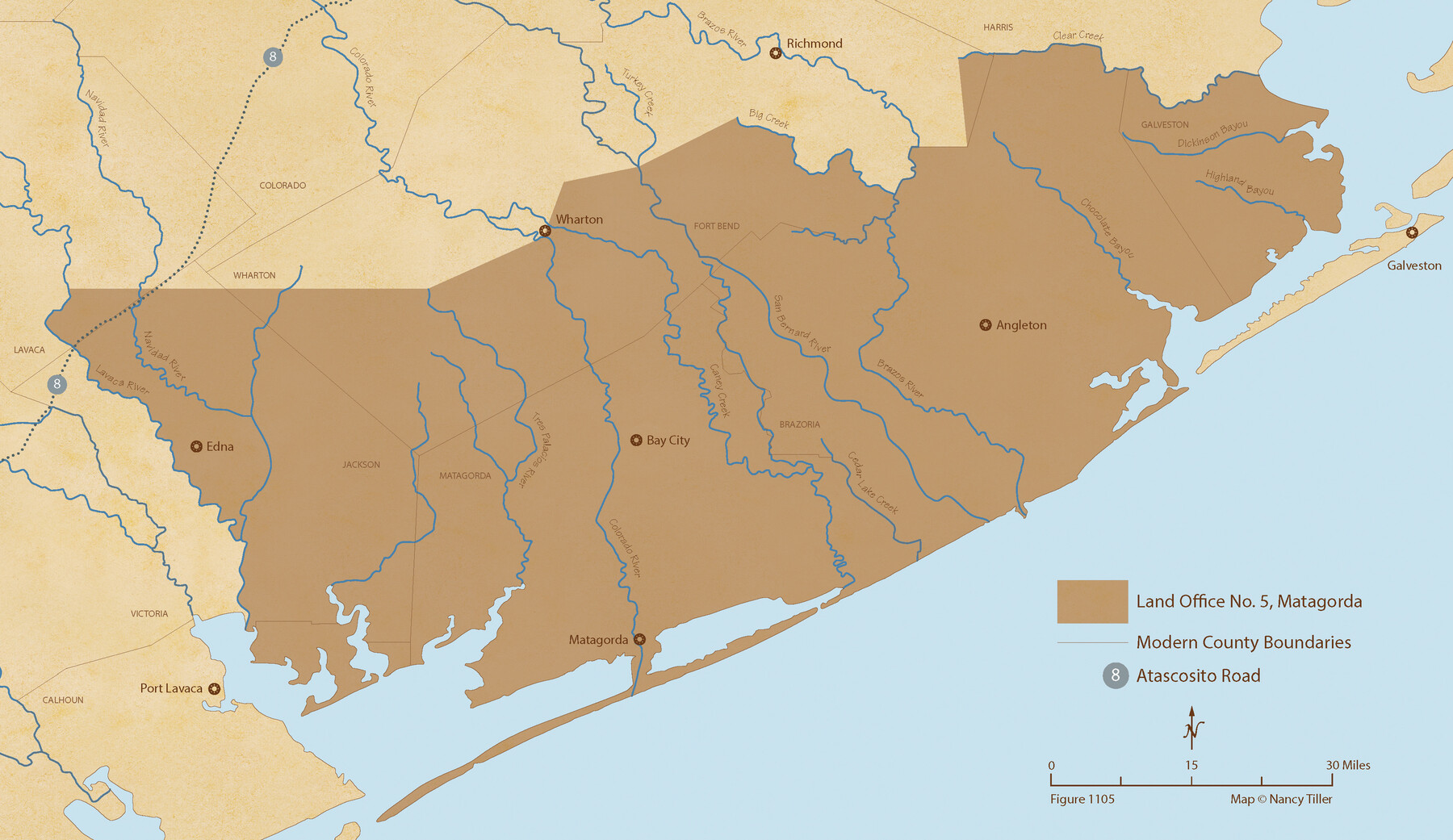
The Land Offices. No. 5, Matagorda, December 22, 1836
Figure No. 1105 from 'A Boundary Atlas of Texas, 1821-1845' by Jim Tiller
-
Map/Doc
96418
-
Collection
Nancy and Jim Tiller Digital Collection
-
Object Dates
2020/1/1 (Creation Date)
-
People and Organizations
Jim Tiller (Author)
Nancy Tiller (Cartographer)
Gang Gong (GIS Professional)
-
Subjects
Atlas Republic of Texas Texas Boundaries
-
Height x Width
12.5 x 21.7 inches
31.8 x 55.1 cm
-
Medium
digital image
-
Comments
To purchase a digital PDF copy of "A Boundary Atlas of Texas, 1821-1845" see 96437.
Part of: Nancy and Jim Tiller Digital Collection
The Chief Justice County of San Patricio. Proposed, No Date

Print $20.00
The Chief Justice County of San Patricio. Proposed, No Date
2020
Size 20.0 x 21.7 inches
Map/Doc 96072
The Republic County of Red River. Boundaries Defined, December 18, 1837

Print $20.00
The Republic County of Red River. Boundaries Defined, December 18, 1837
2020
Size 17.4 x 21.7 inches
Map/Doc 96251
From Citizens of Montgomery County for the Creation of a New County to be Called Bowie, January 18, 1838

Print $20.00
From Citizens of Montgomery County for the Creation of a New County to be Called Bowie, January 18, 1838
2020
Size 19.1 x 21.7 inches
Map/Doc 96376
The Republic County of San Augustine. December 29, 1845

Print $20.00
The Republic County of San Augustine. December 29, 1845
2020
Size 18.8 x 21.7 inches
Map/Doc 96272
The Republic County of Gonzales. December 18, 1837

Print $20.00
The Republic County of Gonzales. December 18, 1837
2020
Size 14.7 x 21.7 inches
Map/Doc 96154
The Chief Justice County of San Augustine. April 22, 1837

Print $20.00
The Chief Justice County of San Augustine. April 22, 1837
2020
Size 14.6 x 21.7 inches
Map/Doc 96070
The Mexican Municipality of Jackson. Created, December 5, 1835

Print $20.00
The Mexican Municipality of Jackson. Created, December 5, 1835
2020
Size 17.7 x 21.7 inches
Map/Doc 96023
The Republic County of Bowie. January 28, 1841

Print $20.00
The Republic County of Bowie. January 28, 1841
2020
Size 19.5 x 21.7 inches
Map/Doc 96103
From Citizens Living in Red River County for the Creation of a New County (Unnamed), Undated

Print $20.00
From Citizens Living in Red River County for the Creation of a New County (Unnamed), Undated
2020
Size 16.6 x 21.7 inches
Map/Doc 96405
The Republic County of Washington. January 30, 1841

Print $20.00
The Republic County of Washington. January 30, 1841
2020
Size 20.3 x 21.7 inches
Map/Doc 96305
The Republic County of Goliad. Proposed, Late Fall 1837

Print $20.00
The Republic County of Goliad. Proposed, Late Fall 1837
2020
Size 15.1 x 21.7 inches
Map/Doc 96147
Geographical Observations on the Inner Margins of the Border and Coastal Reserves of Texas, 1824-1836

Geographical Observations on the Inner Margins of the Border and Coastal Reserves of Texas, 1824-1836
2022
Map/Doc 97131
You may also like
Flight Mission No. CRK-8P, Frame 122, Refugio County

Print $20.00
- Digital $50.00
Flight Mission No. CRK-8P, Frame 122, Refugio County
1956
Size 18.4 x 22.1 inches
Map/Doc 86977
Hill County Sketch File 2

Print $40.00
- Digital $50.00
Hill County Sketch File 2
1847
Size 15.1 x 12.6 inches
Map/Doc 26461
Bandera County Working Sketch 59

Print $20.00
- Digital $50.00
Bandera County Working Sketch 59
2003
Size 41.1 x 33.9 inches
Map/Doc 78346
Atascosa County Sketch File 25

Print $4.00
- Digital $50.00
Atascosa County Sketch File 25
Size 12.7 x 8.0 inches
Map/Doc 13792

Flight Mission No. DAG-23K, Frame 183, Matagorda County

Print $20.00
- Digital $50.00
Flight Mission No. DAG-23K, Frame 183, Matagorda County
1953
Size 18.5 x 22.3 inches
Map/Doc 86518
Dallas County Working Sketch 5

Print $20.00
- Digital $50.00
Dallas County Working Sketch 5
1941
Size 18.7 x 16.4 inches
Map/Doc 68571
Rusk County Sketch File 6

Print $4.00
Rusk County Sketch File 6
1848
Size 6.3 x 7.9 inches
Map/Doc 35499
Brewster County Rolled Sketch 56

Print $20.00
- Digital $50.00
Brewster County Rolled Sketch 56
Size 43.1 x 37.1 inches
Map/Doc 8481
Houston County Sketch File 4a

Print $4.00
- Digital $50.00
Houston County Sketch File 4a
1858
Size 13.0 x 8.3 inches
Map/Doc 26754
[Movements & Objectives of the 143rd & 144th Infantry on October 12-13, 1918] - Verso
![94136, [Movements & Objectives of the 143rd & 144th Infantry on October 12-13, 1918] - Verso, Non-GLO Digital Images](https://historictexasmaps.com/wmedia_w700/maps/94136-1.tif.jpg)
Print $20.00
[Movements & Objectives of the 143rd & 144th Infantry on October 12-13, 1918] - Verso
1918
Size 42.4 x 30.0 inches
Map/Doc 94136
Wichita County Rolled Sketch 5

Print $20.00
- Digital $50.00
Wichita County Rolled Sketch 5
Size 24.1 x 39.2 inches
Map/Doc 8242