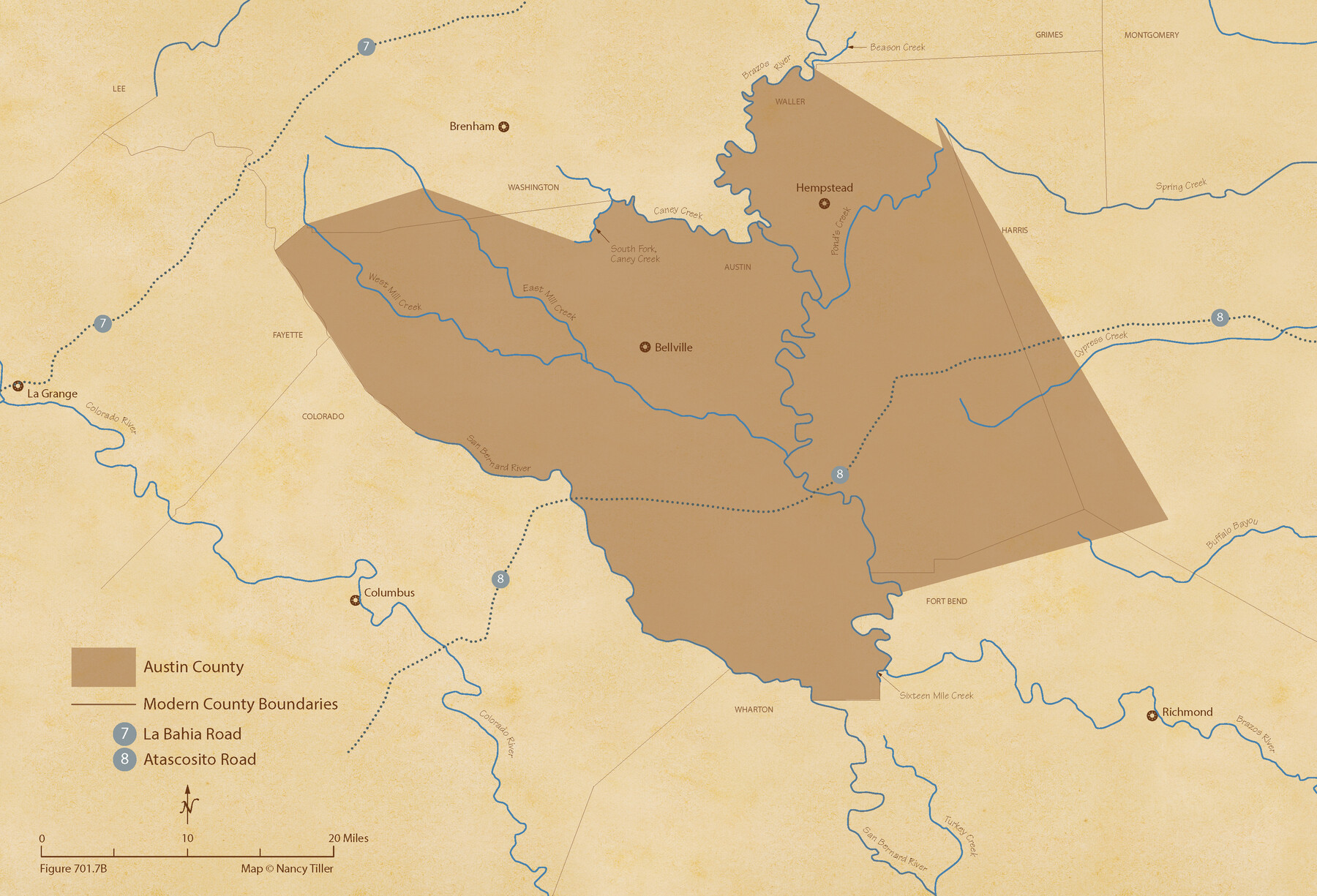
The Republic County of Austin. January 29, 1842
Figure No. 701.7 from 'A Boundary Atlas of Texas, 1821-1845' by Jim Tiller
-
Map/Doc
96086
-
Collection
Nancy and Jim Tiller Digital Collection
-
Object Dates
2020/1/1 (Creation Date)
-
People and Organizations
Jim Tiller (Author)
Nancy Tiller (Cartographer)
Gang Gong (GIS Professional)
-
Counties
Austin
-
Subjects
Atlas County Republic of Texas Texas Boundaries
-
Height x Width
14.7 x 21.7 inches
37.3 x 55.1 cm
-
Medium
digital image
-
Comments
To purchase a digital PDF copy of "A Boundary Atlas of Texas, 1821-1845" see 96437.
Part of: Nancy and Jim Tiller Digital Collection
The Republic County of Lamar. Created, December 17, 1840

Print $20.00
The Republic County of Lamar. Created, December 17, 1840
2020
Size 16.4 x 21.7 inches
Map/Doc 96202
The Mexican Department of Bexar. May 6, 1833

Print $20.00
The Mexican Department of Bexar. May 6, 1833
2020
Size 16.0 x 21.6 inches
Map/Doc 95969
The Republic County of Harris. January 21, 1841

Print $20.00
The Republic County of Harris. January 21, 1841
2020
Size 17.7 x 21.7 inches
Map/Doc 96166
The Republic County of Bowie. Spring 1842

Print $20.00
The Republic County of Bowie. Spring 1842
2020
Size 19.5 x 21.7 inches
Map/Doc 96105
The Republic County of Austin. February 5, 1840

Print $20.00
The Republic County of Austin. February 5, 1840
2020
Size 14.7 x 21.7 inches
Map/Doc 96084
The Republic County of Bexar. North View. Proposed, Fall 1837-December 31, 1838

Print $20.00
The Republic County of Bexar. North View. Proposed, Fall 1837-December 31, 1838
2020
Size 14.0 x 21.1 inches
Map/Doc 96094
Austin Empresario Colony. March 27, 1827

Print $20.00
Austin Empresario Colony. March 27, 1827
2020
Size 18.0 x 21.6 inches
Map/Doc 95980
The Judicial District/County of Burleson. Abolished, Spring 1842

Print $20.00
The Judicial District/County of Burleson. Abolished, Spring 1842
2020
Size 14.1 x 21.7 inches
Map/Doc 96321
The Judicial District/County of Madison. Created, February 2, 1842

Print $20.00
The Judicial District/County of Madison. Created, February 2, 1842
2020
Size 18.2 x 21.7 inches
Map/Doc 96333
From Citizens of Colorado and Matagorda Counties for the Creation of a New County (Unnamed), August 6, 1840

Print $20.00
From Citizens of Colorado and Matagorda Counties for the Creation of a New County (Unnamed), August 6, 1840
2020
Size 18.5 x 21.7 inches
Map/Doc 96389
The Judicial District/County of Lavaca. Abolished, Spring 1842

Print $20.00
The Judicial District/County of Lavaca. Abolished, Spring 1842
2020
Size 14.6 x 21.7 inches
Map/Doc 96332
Purnell and Lovell Empresario Colony. October 22, 1825

Print $20.00
Purnell and Lovell Empresario Colony. October 22, 1825
2020
Size 18.1 x 21.6 inches
Map/Doc 96005
You may also like
El Paso County Boundary File 3

Print $6.00
- Digital $50.00
El Paso County Boundary File 3
Size 9.7 x 6.1 inches
Map/Doc 53035
Glasscock County Sketch File 11

Print $6.00
- Digital $50.00
Glasscock County Sketch File 11
1933
Size 15.7 x 11.4 inches
Map/Doc 24174
Leon County Rolled Sketch 29

Print $20.00
- Digital $50.00
Leon County Rolled Sketch 29
1992
Size 34.6 x 32.9 inches
Map/Doc 6612
Lampasas County Working Sketch 24

Print $20.00
- Digital $50.00
Lampasas County Working Sketch 24
Size 14.3 x 13.3 inches
Map/Doc 61796
Yoakum County Sketch File 10

Print $20.00
- Digital $50.00
Yoakum County Sketch File 10
1902
Size 33.7 x 18.8 inches
Map/Doc 12706
DeWitt County Sketch File 5

Print $4.00
- Digital $50.00
DeWitt County Sketch File 5
1872
Size 13.0 x 8.3 inches
Map/Doc 20803
Edwards County Rolled Sketch 7

Print $20.00
- Digital $50.00
Edwards County Rolled Sketch 7
1881
Size 24.4 x 23.2 inches
Map/Doc 5800
Map of Brazoria County

Print $20.00
- Digital $50.00
Map of Brazoria County
1918
Size 26.1 x 22.6 inches
Map/Doc 1518
Brooks County Rolled Sketch 18

Print $20.00
- Digital $50.00
Brooks County Rolled Sketch 18
Size 11.3 x 16.1 inches
Map/Doc 61786
The Great Texas Coastal Birding Trail, Central Texas Coast

The Great Texas Coastal Birding Trail, Central Texas Coast
Size 33.3 x 36.0 inches
Map/Doc 94340
Travis County Sketch File 75B

Print $20.00
- Digital $50.00
Travis County Sketch File 75B
1992
Size 37.4 x 26.7 inches
Map/Doc 12479
Pecos County Working Sketch 119

Print $20.00
- Digital $50.00
Pecos County Working Sketch 119
1973
Size 42.8 x 30.9 inches
Map/Doc 71592