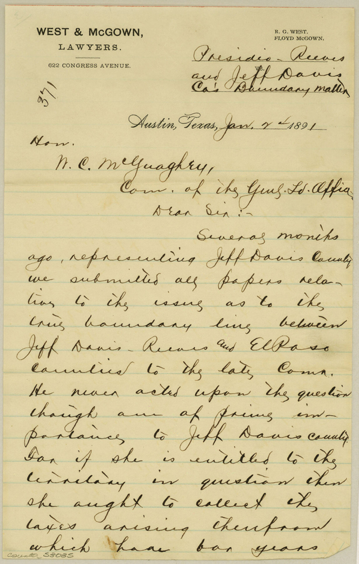
El Paso County Boundary File 3
[Letter regarding Boundary lines between Jeff Davis, Reeves and El Paso Counties]
-
Map/Doc
53035
-
Collection
General Map Collection
-
Counties
El Paso
-
Subjects
County Boundaries
-
Height x Width
9.7 x 6.1 inches
24.6 x 15.5 cm
Part of: General Map Collection
Caldwell County Sketch File 2

Print $40.00
- Digital $50.00
Caldwell County Sketch File 2
1877
Size 12.9 x 20.0 inches
Map/Doc 11030
Morris County Rolled Sketch 2A

Print $20.00
- Digital $50.00
Morris County Rolled Sketch 2A
Size 24.0 x 18.8 inches
Map/Doc 10246
Terrell County Rolled Sketch 40

Print $20.00
- Digital $50.00
Terrell County Rolled Sketch 40
1943
Size 16.7 x 18.1 inches
Map/Doc 7944
Real County Rolled Sketch 18

Print $20.00
- Digital $50.00
Real County Rolled Sketch 18
Size 22.0 x 28.0 inches
Map/Doc 7464
Pecos County Sketch File 60

Print $6.00
- Digital $50.00
Pecos County Sketch File 60
Size 8.2 x 16.5 inches
Map/Doc 33786
Brewster County Rolled Sketch 24E

Print $20.00
- Digital $50.00
Brewster County Rolled Sketch 24E
1906
Size 15.2 x 18.1 inches
Map/Doc 5212
Burnet County Rolled Sketch D

Print $20.00
- Digital $50.00
Burnet County Rolled Sketch D
1924
Size 47.3 x 40.8 inches
Map/Doc 8541
Kenedy County

Print $20.00
- Digital $50.00
Kenedy County
1913
Size 41.0 x 31.8 inches
Map/Doc 66888
Edwards County Rolled Sketch 25

Print $20.00
- Digital $50.00
Edwards County Rolled Sketch 25
1955
Size 30.2 x 35.5 inches
Map/Doc 5811
Limestone County Sketch File 25

Print $20.00
- Digital $50.00
Limestone County Sketch File 25
Size 25.1 x 32.8 inches
Map/Doc 12003
Map showing survey for proposed ship channel from Brownsville to Brazos Santiago Pass

Print $20.00
- Digital $50.00
Map showing survey for proposed ship channel from Brownsville to Brazos Santiago Pass
1912
Size 18.1 x 28.7 inches
Map/Doc 72902
Map of Nacogdoches County

Print $40.00
- Digital $50.00
Map of Nacogdoches County
1896
Size 64.0 x 59.7 inches
Map/Doc 16776
You may also like
Map of Uvalde County

Print $20.00
- Digital $50.00
Map of Uvalde County
1862
Size 27.4 x 20.7 inches
Map/Doc 4109
Lamar County Sketch File 8

Print $20.00
- Digital $50.00
Lamar County Sketch File 8
1895
Size 21.4 x 23.1 inches
Map/Doc 11966
Montgomery County Working Sketch 51

Print $20.00
- Digital $50.00
Montgomery County Working Sketch 51
1960
Size 38.7 x 40.4 inches
Map/Doc 71158
Flight Mission No. DCL-4C, Frame 148, Kenedy County

Print $20.00
- Digital $50.00
Flight Mission No. DCL-4C, Frame 148, Kenedy County
1943
Size 18.6 x 22.5 inches
Map/Doc 85826
General Highway Map, Matagorda County, Texas

Print $20.00
General Highway Map, Matagorda County, Texas
1939
Size 24.7 x 18.3 inches
Map/Doc 79187
La Salle County Working Sketch 24

Print $20.00
- Digital $50.00
La Salle County Working Sketch 24
1947
Size 20.9 x 31.2 inches
Map/Doc 70325
Presidio County Working Sketch 146

Print $20.00
- Digital $50.00
Presidio County Working Sketch 146
1989
Size 20.7 x 20.6 inches
Map/Doc 71824
Briscoe County Sketch File G

Print $40.00
- Digital $50.00
Briscoe County Sketch File G
1918
Size 17.7 x 22.4 inches
Map/Doc 11004
General Highway Map, Knox County, Texas

Print $20.00
General Highway Map, Knox County, Texas
1961
Size 18.2 x 24.9 inches
Map/Doc 79560
Titus County Sketch File 5

Print $4.00
- Digital $50.00
Titus County Sketch File 5
1853
Size 11.7 x 8.2 inches
Map/Doc 38138
Runnels County Sketch File 21

Print $5.00
Runnels County Sketch File 21
Size 11.7 x 15.6 inches
Map/Doc 35488
Wilson County Sketch File 13

Print $4.00
- Digital $50.00
Wilson County Sketch File 13
1873
Size 10.2 x 8.0 inches
Map/Doc 40429