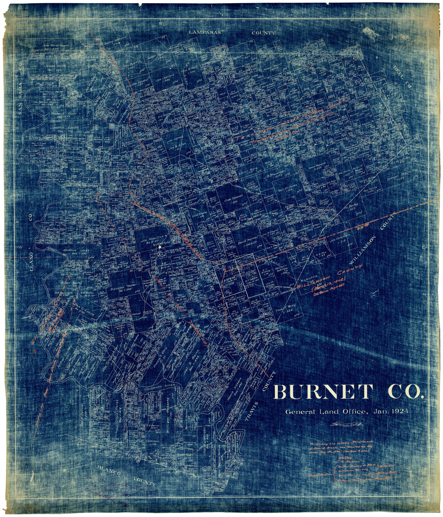
Burnet County Rolled Sketch D
Burnet Co.
-
Map/Doc
8541
-
Collection
General Map Collection
-
Object Dates
1/1924 (Creation Date)
-
People and Organizations
General Land Office (Publisher)
H.F. McDonald (Draftsman)
-
Counties
Burnet
-
Subjects
County Surveying Rolled Sketch
-
Height x Width
47.3 x 40.8 inches
120.1 x 103.6 cm
-
Medium
blueprint/diazo
-
Scale
1" = 2000 varas
Part of: General Map Collection
Van Zandt County Sketch File 32a

Print $4.00
- Digital $50.00
Van Zandt County Sketch File 32a
1860
Size 12.3 x 8.1 inches
Map/Doc 39467
Boundary Between the United States & Mexico Agreed Upon by the Joint Commission under the Treaty of Guadalupe Hidalgo

Print $4.00
- Digital $50.00
Boundary Between the United States & Mexico Agreed Upon by the Joint Commission under the Treaty of Guadalupe Hidalgo
1853
Size 24.9 x 18.1 inches
Map/Doc 65393
Bell County Sketch File 24

Print $4.00
- Digital $50.00
Bell County Sketch File 24
Size 10.0 x 8.0 inches
Map/Doc 14418
Dallas County Working Sketch 2

Print $20.00
- Digital $50.00
Dallas County Working Sketch 2
1917
Size 18.2 x 19.0 inches
Map/Doc 68568
Harris County Rolled Sketch J

Print $40.00
- Digital $50.00
Harris County Rolled Sketch J
1933
Size 53.6 x 41.6 inches
Map/Doc 9122
Howard County Sketch File 12

Print $20.00
- Digital $50.00
Howard County Sketch File 12
1939
Size 18.2 x 15.7 inches
Map/Doc 11799
Denton County Working Sketch 10

Print $20.00
- Digital $50.00
Denton County Working Sketch 10
1960
Size 30.2 x 25.0 inches
Map/Doc 68615
Right-of-Way Map Seawall Extension Galveston Island

Print $40.00
- Digital $50.00
Right-of-Way Map Seawall Extension Galveston Island
1958
Size 16.4 x 62.8 inches
Map/Doc 73617
Flight Mission No. DIX-3P, Frame 172, Aransas County

Print $20.00
- Digital $50.00
Flight Mission No. DIX-3P, Frame 172, Aransas County
1956
Size 17.7 x 18.3 inches
Map/Doc 83778
Culberson County Working Sketch 16

Print $20.00
- Digital $50.00
Culberson County Working Sketch 16
1926
Size 17.5 x 23.4 inches
Map/Doc 68468
Schleicher County Sketch File 47

Print $4.00
- Digital $50.00
Schleicher County Sketch File 47
1953
Size 4.4 x 8.7 inches
Map/Doc 36556
Winkler County Sketch File 10

Print $4.00
- Digital $50.00
Winkler County Sketch File 10
1910
Size 9.1 x 8.3 inches
Map/Doc 40486
You may also like
[Sketch showing the Northwest part of Hale County and the Northeast part of Lamb County]
![93204, [Sketch showing the Northwest part of Hale County and the Northeast part of Lamb County], Twichell Survey Records](https://historictexasmaps.com/wmedia_w700/maps/93204-1.tif.jpg)
Print $40.00
- Digital $50.00
[Sketch showing the Northwest part of Hale County and the Northeast part of Lamb County]
Size 55.1 x 57.3 inches
Map/Doc 93204
Houston County Sketch File 30

Print $4.00
- Digital $50.00
Houston County Sketch File 30
1895
Size 8.3 x 7.1 inches
Map/Doc 26806
Nueces County Rolled Sketch 64

Print $55.00
Nueces County Rolled Sketch 64
1979
Size 25.3 x 38.0 inches
Map/Doc 6911
Bowie County Rolled Sketch 3

Print $57.00
- Digital $50.00
Bowie County Rolled Sketch 3
1970
Size 10.0 x 15.3 inches
Map/Doc 42739
Orange County Sketch File 34

Print $20.00
- Digital $50.00
Orange County Sketch File 34
1929
Size 23.5 x 27.7 inches
Map/Doc 12126
Kleberg County Rolled Sketch 13

Print $20.00
- Digital $50.00
Kleberg County Rolled Sketch 13
1995
Size 39.3 x 33.8 inches
Map/Doc 6554
Presidio County Working Sketch 57

Print $20.00
- Digital $50.00
Presidio County Working Sketch 57
1955
Size 47.3 x 39.3 inches
Map/Doc 71734

Reeves County Working Sketch 41

Print $40.00
- Digital $50.00
Reeves County Working Sketch 41
1973
Size 42.5 x 53.4 inches
Map/Doc 63484
Duval County Sketch File 55

Print $20.00
- Digital $50.00
Duval County Sketch File 55
1937
Size 22.3 x 17.1 inches
Map/Doc 11404
Flight Mission No. DCL-7C, Frame 53, Kenedy County

Print $20.00
- Digital $50.00
Flight Mission No. DCL-7C, Frame 53, Kenedy County
1943
Size 16.7 x 16.4 inches
Map/Doc 86041
Freestone County Working Sketch 6

Print $40.00
- Digital $50.00
Freestone County Working Sketch 6
1921
Size 38.3 x 60.0 inches
Map/Doc 69248