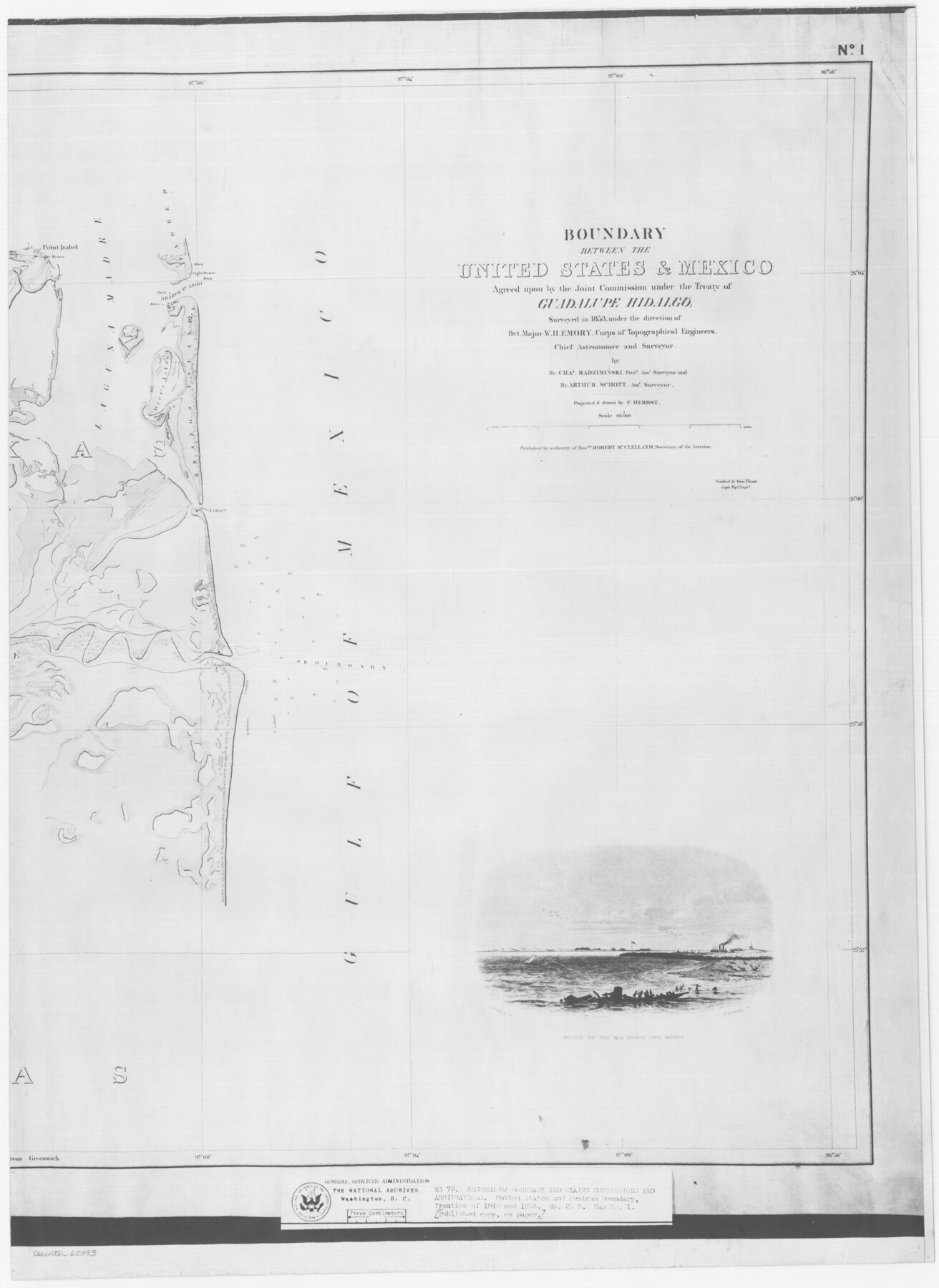
Boundary Between the United States & Mexico Agreed Upon by the Joint Commission under the Treaty of Guadalupe Hidalgo
K-7-67a; K.7.67b
-
Map/Doc
65393
-
Collection
General Map Collection
-
Object Dates
1853 (Creation Date)
-
People and Organizations
F. Herbst (Draftsman)
Chas. Radziminski (Surveyor/Engineer)
Arthur Schott (Surveyor/Engineer)
W.H. Emory (Surveyor/Engineer)
-
Counties
Cameron
-
Subjects
Texas Boundaries
-
Height x Width
24.9 x 18.1 inches
63.2 x 46.0 cm
-
Comments
A composite map of the mouth of the Rio Grande.
From the National Archives, Washington D. C.
For label on reverse side, see counter no. 65392.
Part of: General Map Collection
Randall County Rolled Sketch 3

Print $20.00
- Digital $50.00
Randall County Rolled Sketch 3
Size 22.0 x 24.9 inches
Map/Doc 7423
Sherman County Rolled Sketch 13

Print $20.00
- Digital $50.00
Sherman County Rolled Sketch 13
1951
Size 14.3 x 30.7 inches
Map/Doc 7791
Red River County Sketch File 23

Print $4.00
- Digital $50.00
Red River County Sketch File 23
1901
Size 11.3 x 8.8 inches
Map/Doc 35157
Pecos County Working Sketch 87

Print $20.00
- Digital $50.00
Pecos County Working Sketch 87
1962
Size 29.0 x 31.6 inches
Map/Doc 71559
Duval County Sketch File 22

Print $20.00
- Digital $50.00
Duval County Sketch File 22
1880
Size 31.9 x 23.2 inches
Map/Doc 11386
Nueces County Sketch File 82

Print $4.00
- Digital $50.00
Nueces County Sketch File 82
2000
Size 11.0 x 8.8 inches
Map/Doc 33165
Limestone County Sketch File 1

Print $4.00
- Digital $50.00
Limestone County Sketch File 1
Size 9.8 x 8.1 inches
Map/Doc 30155
Brewster County Rolled Sketch 122

Print $20.00
- Digital $50.00
Brewster County Rolled Sketch 122
1974
Size 31.9 x 24.6 inches
Map/Doc 5298
Concho County Sketch File 53

Print $8.00
- Digital $50.00
Concho County Sketch File 53
2002
Size 11.3 x 8.9 inches
Map/Doc 78515
Fayette County Working Sketch 11

Print $20.00
- Digital $50.00
Fayette County Working Sketch 11
1990
Size 30.8 x 35.0 inches
Map/Doc 69175
Cooke County Sketch File 19

Print $8.00
- Digital $50.00
Cooke County Sketch File 19
1861
Size 7.9 x 6.1 inches
Map/Doc 19260
Navarro County Sketch File 17

Print $4.00
- Digital $50.00
Navarro County Sketch File 17
Size 12.8 x 8.4 inches
Map/Doc 32333
You may also like
Eastland County Sketch File 5

Print $4.00
- Digital $50.00
Eastland County Sketch File 5
Size 6.4 x 7.1 inches
Map/Doc 21570
Colorado River, Shoal Creek from 12th to 34th Street/Austin, Texas

Print $40.00
- Digital $50.00
Colorado River, Shoal Creek from 12th to 34th Street/Austin, Texas
1929
Size 61.5 x 28.6 inches
Map/Doc 65327
Flight Mission No. CRE-1R, Frame 197, Jackson County

Print $20.00
- Digital $50.00
Flight Mission No. CRE-1R, Frame 197, Jackson County
1956
Size 18.5 x 22.4 inches
Map/Doc 85351
DeWitt County Working Sketch 13

Print $20.00
- Digital $50.00
DeWitt County Working Sketch 13
1986
Size 37.6 x 40.9 inches
Map/Doc 68603
Reeves County Boundary File 1

Print $12.00
- Digital $50.00
Reeves County Boundary File 1
Size 14.1 x 8.5 inches
Map/Doc 58195
General Highway Map, McLennan County, Texas

Print $20.00
General Highway Map, McLennan County, Texas
1961
Size 18.2 x 24.6 inches
Map/Doc 79589
Hays County Rolled Sketch 24

Print $20.00
- Digital $50.00
Hays County Rolled Sketch 24
1924
Size 18.4 x 20.9 inches
Map/Doc 6180
Cass County Working Sketch 47b

Print $20.00
- Digital $50.00
Cass County Working Sketch 47b
1992
Size 32.3 x 36.4 inches
Map/Doc 76063
Atascosa County Working Sketch 22

Print $20.00
- Digital $50.00
Atascosa County Working Sketch 22
1956
Size 31.6 x 25.5 inches
Map/Doc 67218
Armstrong County Sketch File A-13

Print $40.00
- Digital $50.00
Armstrong County Sketch File A-13
Size 12.8 x 17.7 inches
Map/Doc 13714

