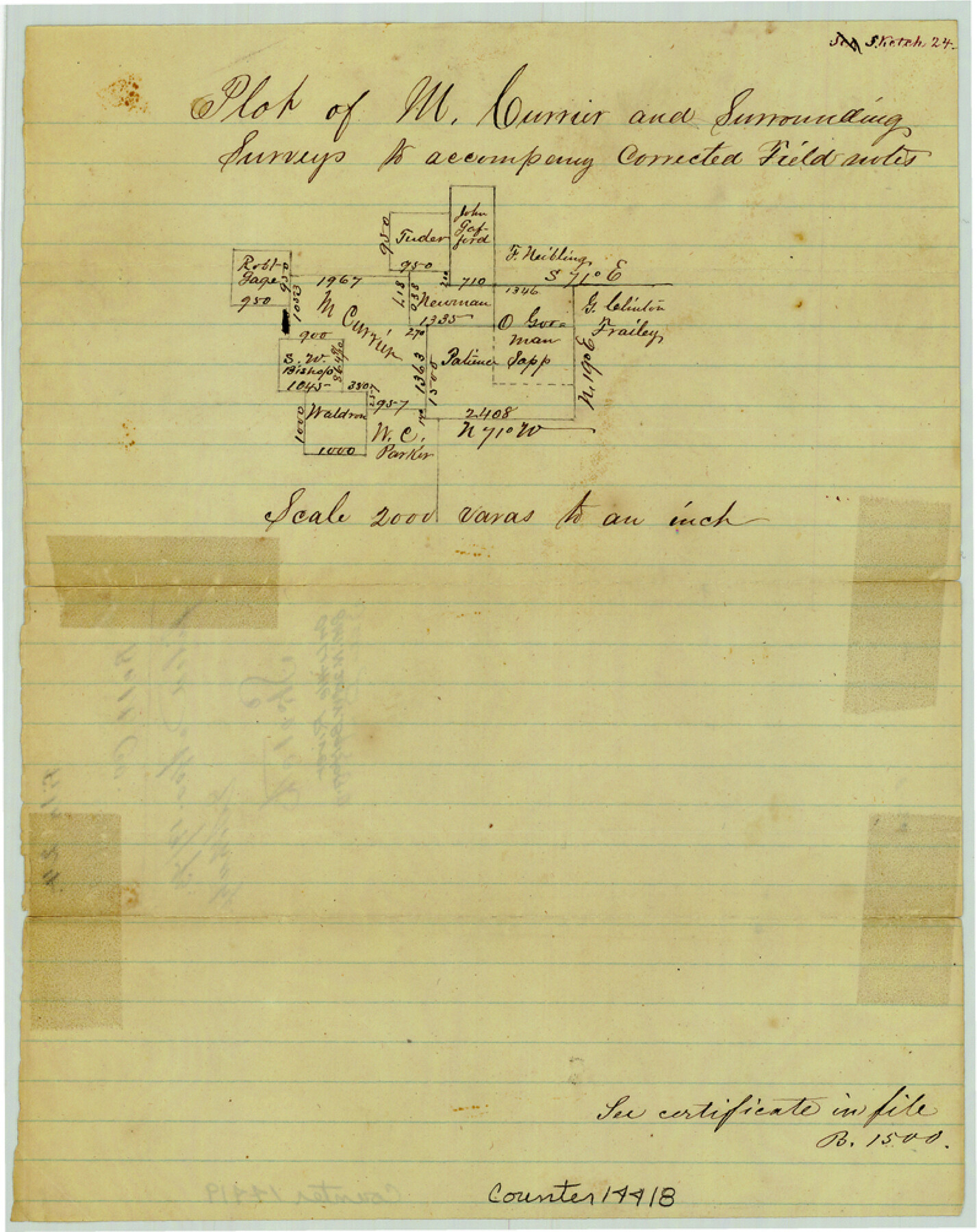
Bell County Sketch File 24
Plot of M. Currier and surrounding surveys
-
Map/Doc
14418
-
Collection
General Map Collection
-
Object Dates
1873/4/19 (File Date)
-
Counties
Bell
-
Subjects
Surveying Sketch File
-
Height x Width
10.0 x 8.0 inches
25.4 x 20.3 cm
-
Medium
paper, manuscript
-
Scale
1" = 2000 varas
Part of: General Map Collection
Baylor County Working Sketch Graphic Index

Print $20.00
- Digital $50.00
Baylor County Working Sketch Graphic Index
1961
Size 41.1 x 33.6 inches
Map/Doc 76463
Bosque County Sketch File 11

Print $4.00
- Digital $50.00
Bosque County Sketch File 11
1863
Size 10.2 x 8.3 inches
Map/Doc 14759
Hunt County Sketch File 35

Print $4.00
- Digital $50.00
Hunt County Sketch File 35
Size 5.3 x 8.3 inches
Map/Doc 27148

Pecos County Rolled Sketch 178

Print $20.00
- Digital $50.00
Pecos County Rolled Sketch 178
1979
Size 38.5 x 28.7 inches
Map/Doc 7298
Terrell County Working Sketch 42

Print $20.00
- Digital $50.00
Terrell County Working Sketch 42
1957
Size 34.4 x 34.4 inches
Map/Doc 62135
Shackelford County Sketch File 17

Print $4.00
Shackelford County Sketch File 17
2009
Size 14.0 x 8.5 inches
Map/Doc 89230
[Surveys in Bastrop County]
![3179, [Surveys in Bastrop County], General Map Collection](https://historictexasmaps.com/wmedia_w700/maps/3179.tif.jpg)
Print $2.00
- Digital $50.00
[Surveys in Bastrop County]
1841
Size 11.3 x 8.4 inches
Map/Doc 3179


Kimble County Working Sketch 64

Print $20.00
- Digital $50.00
Kimble County Working Sketch 64
1964
Size 15.1 x 16.9 inches
Map/Doc 70132
Brewster County Rolled Sketch 114

Print $20.00
- Digital $50.00
Brewster County Rolled Sketch 114
1964
Size 17.3 x 11.4 inches
Map/Doc 5292
You may also like
Texas, Corpus Christi Bay, Mustang Island

Print $40.00
- Digital $50.00
Texas, Corpus Christi Bay, Mustang Island
1934
Size 49.6 x 35.0 inches
Map/Doc 73462
Flight Mission No. DQO-8K, Frame 44, Galveston County

Print $20.00
- Digital $50.00
Flight Mission No. DQO-8K, Frame 44, Galveston County
1952
Size 18.5 x 22.3 inches
Map/Doc 85151
Reeves County

Print $40.00
- Digital $50.00
Reeves County
1945
Size 48.3 x 39.8 inches
Map/Doc 73273
Current Miscellaneous File 61

Print $4.00
- Digital $50.00
Current Miscellaneous File 61
1956
Size 9.3 x 13.6 inches
Map/Doc 74066
Reagan County Rolled Sketch 27A

Print $40.00
- Digital $50.00
Reagan County Rolled Sketch 27A
1952
Size 63.7 x 47.2 inches
Map/Doc 9822
[T. & N. O. Block 3T, Martinez Survey, and William Heath Survey]
![91523, [T. & N. O. Block 3T, Martinez Survey, and William Heath Survey], Twichell Survey Records](https://historictexasmaps.com/wmedia_w700/maps/91523-1.tif.jpg)
Print $20.00
- Digital $50.00
[T. & N. O. Block 3T, Martinez Survey, and William Heath Survey]
Size 13.5 x 14.2 inches
Map/Doc 91523
Pecos County Rolled Sketch 141

Print $40.00
- Digital $50.00
Pecos County Rolled Sketch 141
1927
Size 60.5 x 20.4 inches
Map/Doc 10722
Hudspeth County Working Sketch 16

Print $40.00
- Digital $50.00
Hudspeth County Working Sketch 16
Size 22.2 x 56.6 inches
Map/Doc 69649
Flight Mission No. DIX-10P, Frame 151, Aransas County

Print $20.00
- Digital $50.00
Flight Mission No. DIX-10P, Frame 151, Aransas County
1956
Size 18.7 x 22.3 inches
Map/Doc 83953
Baylor County Sketch File 12D

Print $40.00
- Digital $50.00
Baylor County Sketch File 12D
1900
Size 20.0 x 42.5 inches
Map/Doc 10323
Map of Kyle, Lockhart & Southern Ry.

Print $40.00
- Digital $50.00
Map of Kyle, Lockhart & Southern Ry.
1882
Size 14.5 x 94.9 inches
Map/Doc 64285
Presidio County Sketch File S

Print $27.00
- Digital $50.00
Presidio County Sketch File S
1917
Size 14.3 x 8.8 inches
Map/Doc 34561