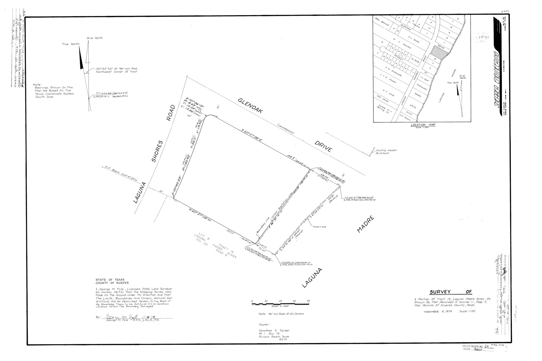
Nueces County Rolled Sketch 64
[Sketch, report, and exhibits regarding a survey of the shoreline boundary of a portion of Tract 13, Laguna Madre Acres]
-
Map/Doc
6911
-
Collection
General Map Collection
-
Object Dates
1979 (Creation Date)
11/10/1979 (File Date)
-
People and Organizations
George M. Pyle (Surveyor/Engineer)
-
Counties
Nueces
-
Subjects
Surveying Rolled Sketch
-
Height x Width
25.3 x 38.0 inches
64.3 x 96.5 cm
-
Scale
1" = 20 feet
Part of: General Map Collection
El Paso County Rolled Sketch 65

Print $20.00
- Digital $50.00
El Paso County Rolled Sketch 65
2012
Size 24.5 x 36.8 inches
Map/Doc 93327
Lipscomb County Boundary File 10

Print $18.00
- Digital $50.00
Lipscomb County Boundary File 10
Size 11.2 x 8.6 inches
Map/Doc 56338
Flight Mission No. CRC-6R, Frame 37, Chambers County

Print $20.00
- Digital $50.00
Flight Mission No. CRC-6R, Frame 37, Chambers County
1956
Size 18.5 x 22.4 inches
Map/Doc 84970
Delta County Sketch File 2

Print $4.00
- Digital $50.00
Delta County Sketch File 2
1871
Size 8.4 x 13.2 inches
Map/Doc 20670
Reagan County Working Sketch 5

Print $20.00
- Digital $50.00
Reagan County Working Sketch 5
1924
Size 19.2 x 19.5 inches
Map/Doc 71845
Culberson County Rolled Sketch 49

Print $20.00
- Digital $50.00
Culberson County Rolled Sketch 49
1961
Size 22.4 x 29.0 inches
Map/Doc 5668
Loving County Sketch File 3

Print $6.00
- Digital $50.00
Loving County Sketch File 3
1952
Size 11.2 x 8.7 inches
Map/Doc 30409
Upton County Rolled Sketch 55

Print $40.00
- Digital $50.00
Upton County Rolled Sketch 55
Size 192.5 x 25.4 inches
Map/Doc 10060
Zapata County Working Sketch 5

Print $20.00
- Digital $50.00
Zapata County Working Sketch 5
1940
Size 23.4 x 18.3 inches
Map/Doc 62056
Flight Mission No. CRC-3R, Frame 102, Chambers County

Print $20.00
- Digital $50.00
Flight Mission No. CRC-3R, Frame 102, Chambers County
1956
Size 18.7 x 22.5 inches
Map/Doc 84840
Yoakum County Sketch File 9

Print $20.00
- Digital $50.00
Yoakum County Sketch File 9
Size 14.1 x 8.9 inches
Map/Doc 40753
Erath County Working Sketch 45

Print $20.00
- Digital $50.00
Erath County Working Sketch 45
1982
Size 25.5 x 24.8 inches
Map/Doc 69126
You may also like
[Bastrop District]
![3131, [Bastrop District], General Map Collection](https://historictexasmaps.com/wmedia_w700/maps/3131.tif.jpg)
Print $40.00
- Digital $50.00
[Bastrop District]
1895
Size 36.5 x 52.0 inches
Map/Doc 3131

Nueces County Rolled Sketch 50

Print $20.00
- Digital $50.00
Nueces County Rolled Sketch 50
1939
Size 21.9 x 38.0 inches
Map/Doc 9605
Johnson County Sketch File 22

Print $20.00
- Digital $50.00
Johnson County Sketch File 22
1873
Size 18.8 x 16.2 inches
Map/Doc 11891
Menard County Working Sketch 18

Print $20.00
- Digital $50.00
Menard County Working Sketch 18
1946
Size 30.6 x 31.0 inches
Map/Doc 70965
Fractional Township No. 7 South Range No. 4 East of the Indian Meridian, Indian Territory

Print $20.00
- Digital $50.00
Fractional Township No. 7 South Range No. 4 East of the Indian Meridian, Indian Territory
1898
Size 19.3 x 24.4 inches
Map/Doc 75207
Flight Mission No. BRA-7M, Frame 141, Jefferson County

Print $20.00
- Digital $50.00
Flight Mission No. BRA-7M, Frame 141, Jefferson County
1953
Size 18.6 x 22.4 inches
Map/Doc 85535
Webb County Working Sketch 1

Print $20.00
- Digital $50.00
Webb County Working Sketch 1
Size 15.6 x 14.4 inches
Map/Doc 72366
[Sketch of PSL Blocks A20, A35, A44, A45]
![89739, [Sketch of PSL Blocks A20, A35, A44, A45], Twichell Survey Records](https://historictexasmaps.com/wmedia_w700/maps/89739-1.tif.jpg)
Print $40.00
- Digital $50.00
[Sketch of PSL Blocks A20, A35, A44, A45]
Size 22.7 x 66.9 inches
Map/Doc 89739
The Spot Map of San Antonio including a classified directory showing location of postal zones, points of interest, places of business - and how to get there

Print $20.00
- Digital $50.00
The Spot Map of San Antonio including a classified directory showing location of postal zones, points of interest, places of business - and how to get there
1941
Size 21.2 x 28.2 inches
Map/Doc 95953
Kerr County Working Sketch 3

Print $20.00
- Digital $50.00
Kerr County Working Sketch 3
1944
Size 15.7 x 21.0 inches
Map/Doc 70034
Steele Addition, Seagraves, Texas

Print $20.00
- Digital $50.00
Steele Addition, Seagraves, Texas
Size 17.4 x 26.3 inches
Map/Doc 92655