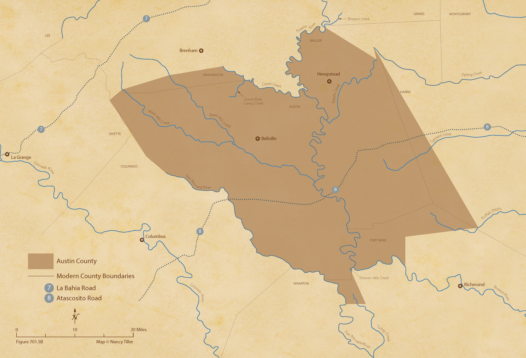
The Republic County of Austin. February 5, 1840
Figure No. 701.5 from 'A Boundary Atlas of Texas, 1821-1845' by Jim Tiller
-
Map/Doc
96084
-
Collection
Nancy and Jim Tiller Digital Collection
-
Object Dates
2020/1/1 (Creation Date)
-
People and Organizations
Jim Tiller (Author)
Nancy Tiller (Cartographer)
Gang Gong (GIS Professional)
-
Counties
Austin
-
Subjects
Atlas County Republic of Texas Texas Boundaries
-
Height x Width
14.7 x 21.7 inches
37.3 x 55.1 cm
-
Medium
digital image
-
Comments
To purchase a digital PDF copy of "A Boundary Atlas of Texas, 1821-1845" see 96437.
Part of: Nancy and Jim Tiller Digital Collection
The Republic County of Lamar. January 3, 1844

Print $20.00
The Republic County of Lamar. January 3, 1844
2020
Size 16.4 x 21.7 inches
Map/Doc 96206
The Republic County of Red River. Boundaries Defined, December 18, 1837

Print $20.00
The Republic County of Red River. Boundaries Defined, December 18, 1837
2020
Size 17.4 x 21.7 inches
Map/Doc 96251
The Republic County of Fort Bend. January 10, 1839

Print $20.00
The Republic County of Fort Bend. January 10, 1839
2020
Size 14.7 x 21.6 inches
Map/Doc 96138
The Judicial District/County of DeWitt. Created, February 2, 1842

Print $20.00
The Judicial District/County of DeWitt. Created, February 2, 1842
2020
Size 22.4 x 21.7 inches
Map/Doc 96325
The Republic County of Washington. February 4, 1840

Print $20.00
The Republic County of Washington. February 4, 1840
2020
Size 20.3 x 21.7 inches
Map/Doc 96304
Dominguez Empresario Colony. February 6, 1829

Print $20.00
Dominguez Empresario Colony. February 6, 1829
2020
Size 17.2 x 21.7 inches
Map/Doc 95992
Cameron Empresario Colony. September 28, 1828

Print $20.00
Cameron Empresario Colony. September 28, 1828
2020
Size 10.4 x 21.7 inches
Map/Doc 95987
The Chief Justice County of Washington. Lands in Conflict with Nacogdoches County

Print $20.00
The Chief Justice County of Washington. Lands in Conflict with Nacogdoches County
2020
Size 13.0 x 21.7 inches
Map/Doc 96078
The Judicial District/County of Panola. Created, January 30, 1841

Print $20.00
The Judicial District/County of Panola. Created, January 30, 1841
2020
Size 19.3 x 21.6 inches
Map/Doc 96340
The Republic County of Bexar. January 29, 1842

Print $20.00
The Republic County of Bexar. January 29, 1842
2020
Size 14.7 x 21.7 inches
Map/Doc 96099
The Chief Justice County of Victoria. September 20, 1837

Print $20.00
The Chief Justice County of Victoria. September 20, 1837
2020
Size 23.3 x 21.7 inches
Map/Doc 96075
The Republic County of Liberty. Boundaries Defined, December 18, 1837

Print $20.00
The Republic County of Liberty. Boundaries Defined, December 18, 1837
2020
Size 19.9 x 21.7 inches
Map/Doc 96208
You may also like

Flight Mission No. BRA-8M, Frame 26, Jefferson County

Print $20.00
- Digital $50.00
Flight Mission No. BRA-8M, Frame 26, Jefferson County
1953
Size 18.6 x 22.3 inches
Map/Doc 85581
General Highway Map, Houston County, Texas

Print $20.00
General Highway Map, Houston County, Texas
1961
Size 24.6 x 18.3 inches
Map/Doc 79524
Van Zandt County Sketch File 19

Print $4.00
- Digital $50.00
Van Zandt County Sketch File 19
1858
Size 9.7 x 7.7 inches
Map/Doc 39422
[Sections 15, 16, 17, 18, Block B]
![92798, [Sections 15, 16, 17, 18, Block B], Twichell Survey Records](https://historictexasmaps.com/wmedia_w700/maps/92798-1.tif.jpg)
Print $20.00
- Digital $50.00
[Sections 15, 16, 17, 18, Block B]
Size 40.0 x 10.5 inches
Map/Doc 92798
Gaines County Sketch File 16

Print $20.00
- Digital $50.00
Gaines County Sketch File 16
1958
Size 22.0 x 17.4 inches
Map/Doc 11526
Map of Galveston, Turtle & East Bays & portion of the Gulf of Mexico in Chambers & Galveston Counties, Texas showing subdivision therof for mineral development

Print $20.00
- Digital $50.00
Map of Galveston, Turtle & East Bays & portion of the Gulf of Mexico in Chambers & Galveston Counties, Texas showing subdivision therof for mineral development
1935
Size 40.7 x 47.7 inches
Map/Doc 2939
Haskell County Boundary File 1

Print $36.00
- Digital $50.00
Haskell County Boundary File 1
Size 8.7 x 9.0 inches
Map/Doc 54518
Navarro County Sketch File 12

Print $4.00
- Digital $50.00
Navarro County Sketch File 12
Size 7.0 x 7.0 inches
Map/Doc 32322
Jefferson County Rolled Sketch 48

Print $20.00
- Digital $50.00
Jefferson County Rolled Sketch 48
1963
Size 28.3 x 34.8 inches
Map/Doc 6403
Sec. 22, Block 103

Print $20.00
- Digital $50.00
Sec. 22, Block 103
Size 13.1 x 14.8 inches
Map/Doc 90120
Nolan County, Texas

Print $20.00
- Digital $50.00
Nolan County, Texas
1880
Size 29.5 x 22.7 inches
Map/Doc 588