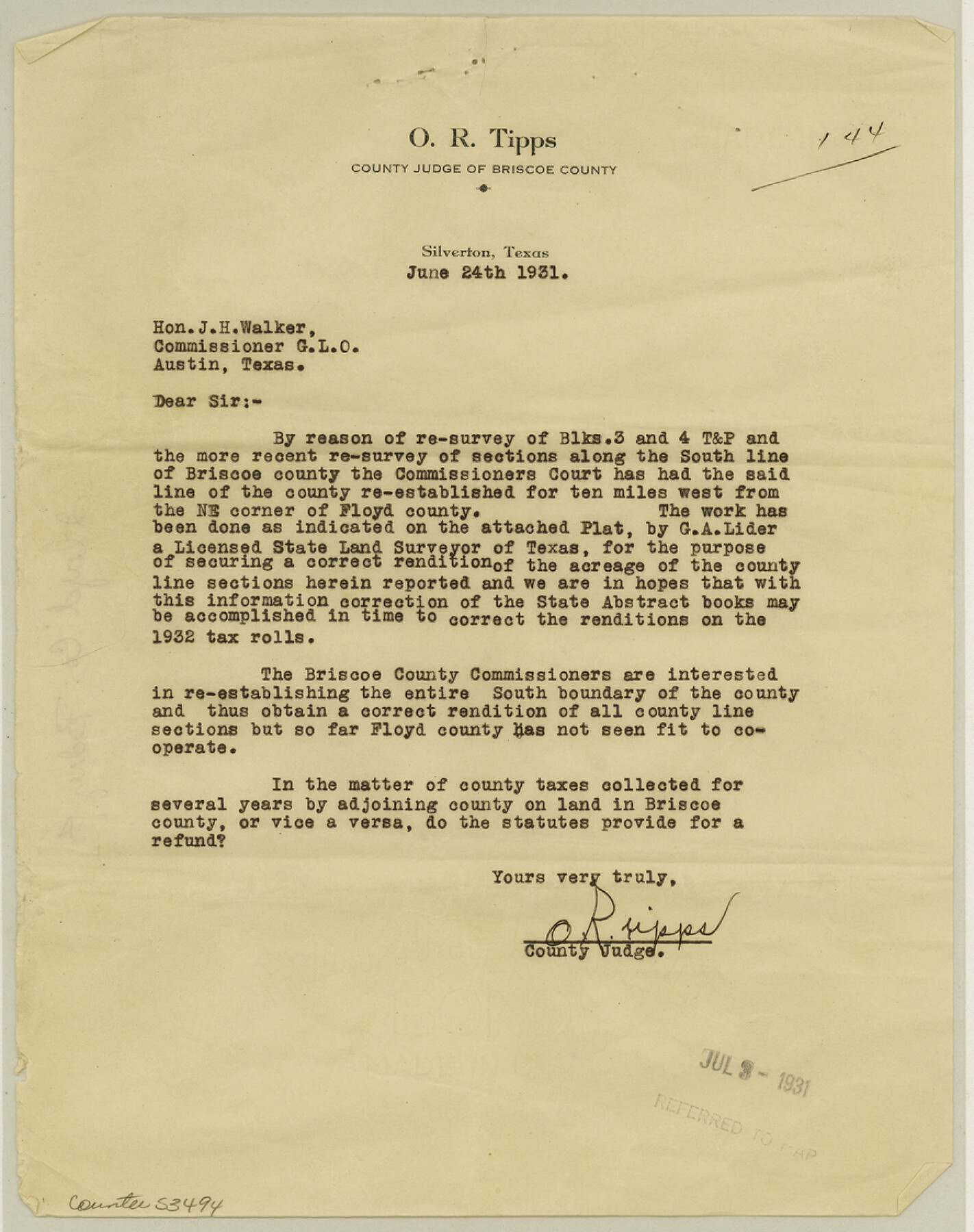
Floyd County Boundary File 4
[Letter regarding Floyd-Briscoe County line
-
Map/Doc
53494
-
Collection
General Map Collection
-
Counties
Floyd
-
Subjects
County Boundaries
-
Height x Width
11.2 x 8.9 inches
28.5 x 22.6 cm
Part of: General Map Collection
Webb County Rolled Sketch 44

Print $20.00
- Digital $50.00
Webb County Rolled Sketch 44
1941
Size 23.9 x 20.1 inches
Map/Doc 8199
Glasscock County

Print $20.00
- Digital $50.00
Glasscock County
1933
Size 46.4 x 38.8 inches
Map/Doc 66838
Nueces County Sketch File 46

Print $44.00
- Digital $50.00
Nueces County Sketch File 46
1907
Size 11.1 x 8.7 inches
Map/Doc 32643
Midland County Rolled Sketch 4B

Print $40.00
- Digital $50.00
Midland County Rolled Sketch 4B
1951
Size 77.5 x 25.1 inches
Map/Doc 10725
Atlantic Coast to the Rocky Mountains

Atlantic Coast to the Rocky Mountains
1956
Size 42.5 x 29.4 inches
Map/Doc 94409
[Surveys in Liberty County]
![69750, [Surveys in Liberty County], General Map Collection](https://historictexasmaps.com/wmedia_w700/maps/69750.tif.jpg)
Print $2.00
- Digital $50.00
[Surveys in Liberty County]
Size 5.8 x 9.3 inches
Map/Doc 69750
Jeff Davis County

Print $40.00
- Digital $50.00
Jeff Davis County
1893
Size 26.2 x 48.2 inches
Map/Doc 3719
Flight Mission No. CRK-3P, Frame 67, Refugio County

Print $20.00
- Digital $50.00
Flight Mission No. CRK-3P, Frame 67, Refugio County
1956
Size 18.5 x 22.3 inches
Map/Doc 86909
Terrell County Rolled Sketch 49

Print $20.00
- Digital $50.00
Terrell County Rolled Sketch 49
1962
Size 17.3 x 24.1 inches
Map/Doc 7951
Wood County Working Sketch 15

Print $20.00
- Digital $50.00
Wood County Working Sketch 15
1981
Size 25.7 x 31.7 inches
Map/Doc 62015
Terry County Sketch File 15

Print $10.00
- Digital $50.00
Terry County Sketch File 15
1944
Size 11.3 x 8.9 inches
Map/Doc 38034
Flight Mission No. BQY-14M, Frame 182, Harris County

Print $20.00
- Digital $50.00
Flight Mission No. BQY-14M, Frame 182, Harris County
1953
Size 18.5 x 22.4 inches
Map/Doc 85298
You may also like
Upton County Working Sketch 53

Print $20.00
- Digital $50.00
Upton County Working Sketch 53
1983
Size 26.8 x 31.2 inches
Map/Doc 69550
Haskell County Rolled Sketch 9

Print $20.00
- Digital $50.00
Haskell County Rolled Sketch 9
Size 16.4 x 34.3 inches
Map/Doc 6168
Lake Worth Boundary

Print $20.00
- Digital $50.00
Lake Worth Boundary
Size 19.5 x 33.4 inches
Map/Doc 62212
Gillespie County Sketch File 9

Print $4.00
- Digital $50.00
Gillespie County Sketch File 9
1873
Size 8.2 x 10.5 inches
Map/Doc 24145
J. De Cordova's Map of the State of Texas Compiled from the records of the General Land Office of the State

Print $20.00
J. De Cordova's Map of the State of Texas Compiled from the records of the General Land Office of the State
1872
Size 34.3 x 31.9 inches
Map/Doc 76216
Kerr County Working Sketch 20

Print $20.00
- Digital $50.00
Kerr County Working Sketch 20
1960
Size 37.1 x 41.5 inches
Map/Doc 70051
Reagan County Working Sketch 45

Print $20.00
- Digital $50.00
Reagan County Working Sketch 45
1987
Size 30.1 x 43.1 inches
Map/Doc 71887
Andrews County Working Sketch 33

Print $20.00
- Digital $50.00
Andrews County Working Sketch 33
1990
Size 32.9 x 29.7 inches
Map/Doc 67079
Val Verde County Working Sketch 68

Print $20.00
- Digital $50.00
Val Verde County Working Sketch 68
1965
Size 37.3 x 44.2 inches
Map/Doc 72203
Moore County Sketch File 4

Print $20.00
- Digital $50.00
Moore County Sketch File 4
1895
Size 17.2 x 29.4 inches
Map/Doc 42127
G. P. Co. Survey of A. C. Daws Tr. Lease No. 6453

Print $20.00
- Digital $50.00
G. P. Co. Survey of A. C. Daws Tr. Lease No. 6453
1920
Size 18.9 x 27.9 inches
Map/Doc 92022
Flight Mission No. DQN-5K, Frame 27, Calhoun County

Print $20.00
- Digital $50.00
Flight Mission No. DQN-5K, Frame 27, Calhoun County
1953
Size 18.4 x 22.1 inches
Map/Doc 84378