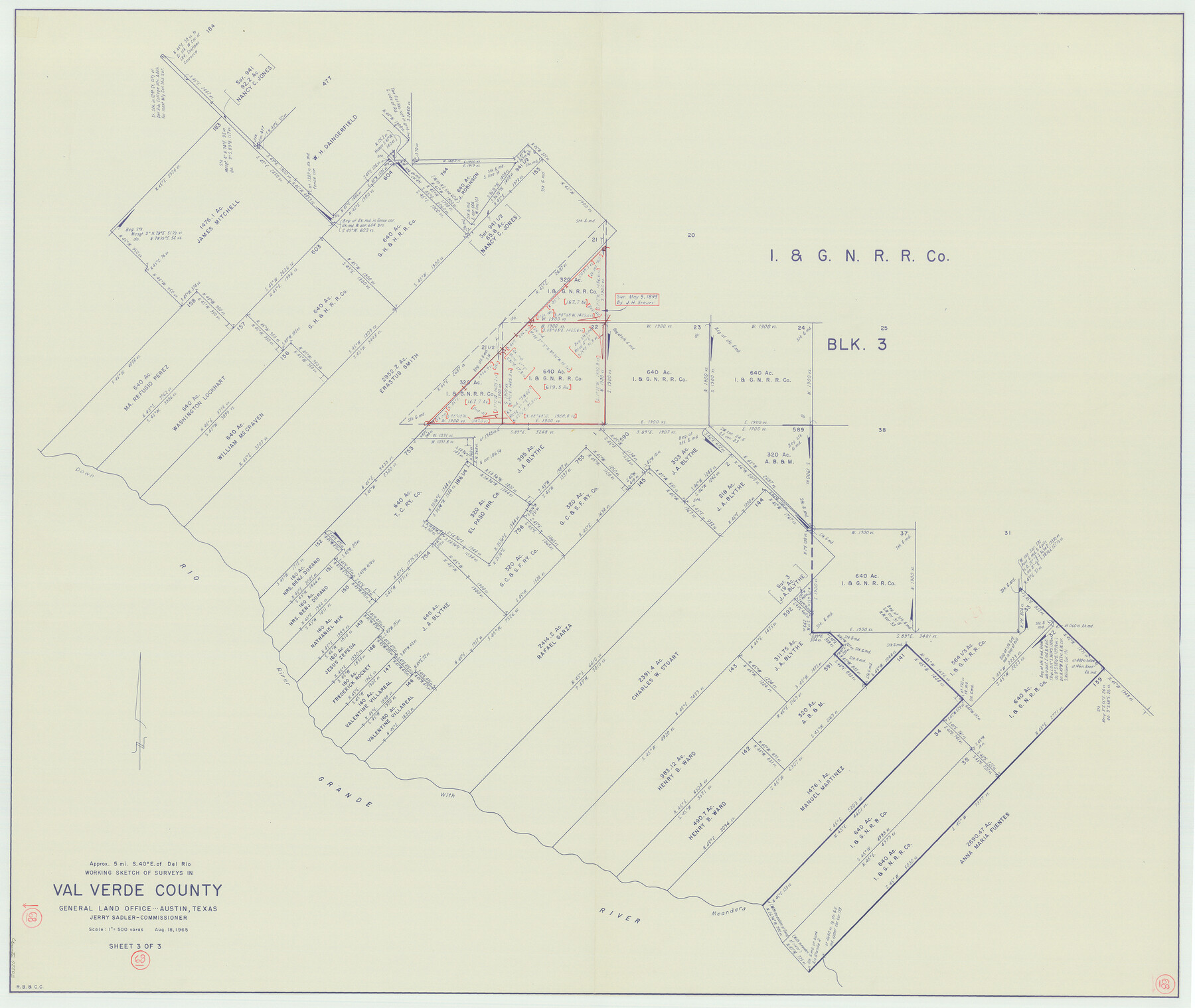
Val Verde County Working Sketch 68
-
Map/Doc
72203
-
Collection
General Map Collection
-
Object Dates
8/18/1965 (Creation Date)
-
People and Organizations
Roy Buckholts (Draftsman)
-
Counties
Val Verde
-
Subjects
Surveying Working Sketch
-
Height x Width
37.3 x 44.2 inches
94.7 x 112.3 cm
-
Scale
1" = 500 varas
Part of: General Map Collection
Ft. W. & R. G. Ry. Right of Way Map, Chapin to Bluffdale, Hood County, Texas

Print $40.00
- Digital $50.00
Ft. W. & R. G. Ry. Right of Way Map, Chapin to Bluffdale, Hood County, Texas
1918
Size 36.5 x 50.5 inches
Map/Doc 64645
United States - Gulf Coast - From Latitude 26° 33' to the Rio Grande Texas

Print $20.00
- Digital $50.00
United States - Gulf Coast - From Latitude 26° 33' to the Rio Grande Texas
1918
Size 18.5 x 24.5 inches
Map/Doc 72847
Mills County Sketch File 27

Print $8.00
- Digital $50.00
Mills County Sketch File 27
2000
Size 14.4 x 8.7 inches
Map/Doc 31680
Colorado County Sketch File 2

Print $4.00
- Digital $50.00
Colorado County Sketch File 2
Size 11.1 x 8.4 inches
Map/Doc 18911
[Nueces Bay Islands and Nesting Birds]
![2084, [Nueces Bay Islands and Nesting Birds], General Map Collection](https://historictexasmaps.com/wmedia_w700/maps/2084.tif.jpg)
Print $20.00
- Digital $50.00
[Nueces Bay Islands and Nesting Birds]
1940
Size 18.1 x 24.2 inches
Map/Doc 2084

Chart of the West Indies and Spanish Dominions in North America

Print $20.00
- Digital $50.00
Chart of the West Indies and Spanish Dominions in North America
1803
Size 25.3 x 38.4 inches
Map/Doc 97136
Henderson County Working Sketch 21

Print $20.00
- Digital $50.00
Henderson County Working Sketch 21
1948
Size 17.1 x 16.2 inches
Map/Doc 66154
Cherokee County Working Sketch 16

Print $20.00
- Digital $50.00
Cherokee County Working Sketch 16
1958
Size 21.9 x 22.5 inches
Map/Doc 67971
Roberts County Rolled Sketch 4

Print $52.00
- Digital $50.00
Roberts County Rolled Sketch 4
2006
Size 66.9 x 20.0 inches
Map/Doc 83620
The Great European Alliance against the Mexican Republic

Print $20.00
- Digital $50.00
The Great European Alliance against the Mexican Republic
1861
Size 22.9 x 16.2 inches
Map/Doc 96429
Zavala County Sketch File 39

Print $4.00
- Digital $50.00
Zavala County Sketch File 39
1884
Size 14.4 x 8.7 inches
Map/Doc 41404
You may also like
Van Zandt County Sketch File 37

Print $4.00
- Digital $50.00
Van Zandt County Sketch File 37
1861
Size 12.2 x 7.8 inches
Map/Doc 39480
Gaines County Rolled Sketch 12

Print $20.00
- Digital $50.00
Gaines County Rolled Sketch 12
1940
Size 26.6 x 33.8 inches
Map/Doc 5932
Flight Mission No. DAG-21K, Frame 35, Matagorda County

Print $20.00
- Digital $50.00
Flight Mission No. DAG-21K, Frame 35, Matagorda County
1952
Size 18.6 x 22.4 inches
Map/Doc 86402
Irion County Working Sketch 16

Print $20.00
- Digital $50.00
Irion County Working Sketch 16
1973
Size 37.8 x 36.7 inches
Map/Doc 66425
Double Lakes No. 1 T-Ranch Lynn County, Texas

Print $20.00
- Digital $50.00
Double Lakes No. 1 T-Ranch Lynn County, Texas
Size 36.8 x 31.8 inches
Map/Doc 93216
Atascosa County Sketch File 42

Print $12.00
- Digital $50.00
Atascosa County Sketch File 42
1916
Size 11.2 x 8.8 inches
Map/Doc 13847
Map of the State of Texas

Print $40.00
- Digital $50.00
Map of the State of Texas
1879
Size 102.7 x 56.3 inches
Map/Doc 93382
Denton County Sketch File 36a

Print $6.00
- Digital $50.00
Denton County Sketch File 36a
1898
Size 11.3 x 9.1 inches
Map/Doc 20773
Reagan County Rolled Sketch 14

Print $20.00
- Digital $50.00
Reagan County Rolled Sketch 14
1942
Size 19.8 x 21.2 inches
Map/Doc 7442
Flight Mission No. CZW-1R, Frame 116, Hardeman County

Print $20.00
- Digital $50.00
Flight Mission No. CZW-1R, Frame 116, Hardeman County
1956
Size 18.6 x 19.0 inches
Map/Doc 85235
Hardin County Sketch File 15

Print $6.00
- Digital $50.00
Hardin County Sketch File 15
Size 9.0 x 4.9 inches
Map/Doc 25122
Controlled Mosaic by Jack Amman Photogrammetric Engineers, Inc - Sheet 27

Print $20.00
- Digital $50.00
Controlled Mosaic by Jack Amman Photogrammetric Engineers, Inc - Sheet 27
1954
Size 20.0 x 24.0 inches
Map/Doc 83478