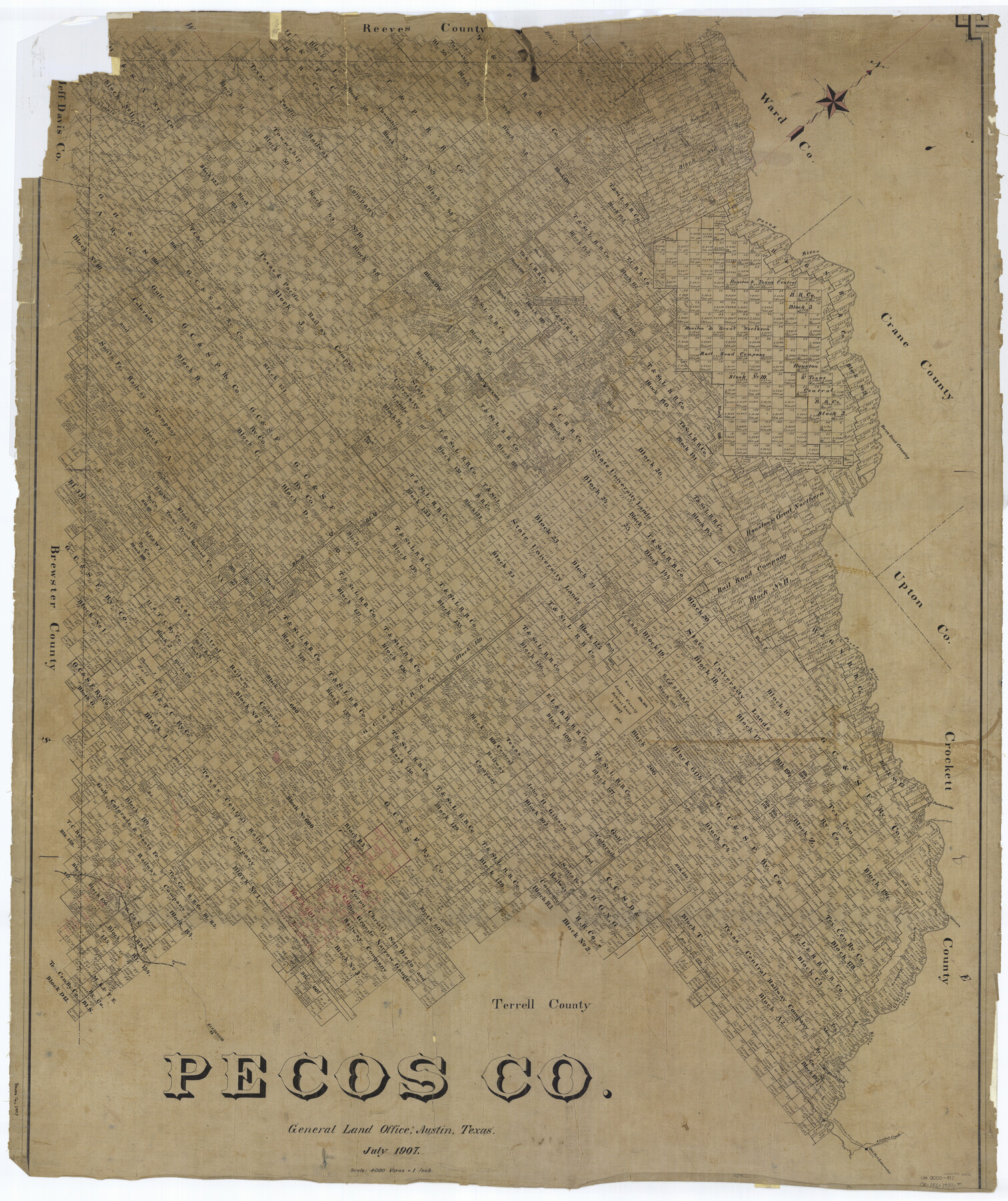
Pecos Co.
-
Map/Doc
66976
-
Collection
General Map Collection
-
Object Dates
1907 (Creation Date)
-
People and Organizations
Texas General Land Office (Publisher)
-
Counties
Pecos
-
Subjects
County
-
Height x Width
47.8 x 40.1 inches
121.4 x 101.9 cm
Part of: General Map Collection
Leon County Sketch File 27

Print $20.00
- Digital $50.00
Leon County Sketch File 27
1948
Size 11.2 x 8.8 inches
Map/Doc 29811
Map of Anderson County

Print $20.00
- Digital $50.00
Map of Anderson County
1855
Size 23.7 x 28.9 inches
Map/Doc 3225
United States

Print $20.00
- Digital $50.00
United States
1851
Size 10.8 x 15.1 inches
Map/Doc 93799
Fannin County Working Sketch 2

Print $3.00
- Digital $50.00
Fannin County Working Sketch 2
1911
Size 14.9 x 10.3 inches
Map/Doc 69156
Martin County Sketch File 14

Print $46.00
- Digital $50.00
Martin County Sketch File 14
1937
Size 11.2 x 8.8 inches
Map/Doc 30671
Denton County Rolled Sketch 7

Print $20.00
- Digital $50.00
Denton County Rolled Sketch 7
2007
Size 24.5 x 19.3 inches
Map/Doc 87941
Polk County Sketch File 36

Print $46.00
- Digital $50.00
Polk County Sketch File 36
1908
Size 13.8 x 8.6 inches
Map/Doc 34236
Flight Mission No. CRC-3R, Frame 6, Chambers County

Print $20.00
- Digital $50.00
Flight Mission No. CRC-3R, Frame 6, Chambers County
1956
Size 18.6 x 22.3 inches
Map/Doc 84780
Controlled Mosaic by Jack Amman Photogrammetric Engineers, Inc - Sheet 37

Print $20.00
- Digital $50.00
Controlled Mosaic by Jack Amman Photogrammetric Engineers, Inc - Sheet 37
1954
Size 20.0 x 24.0 inches
Map/Doc 83490
Moore County Working Sketch 8

Print $20.00
- Digital $50.00
Moore County Working Sketch 8
1948
Size 23.2 x 31.8 inches
Map/Doc 71190
[Surveys in Milam's Colony along the Colorado River and Onion Creek]
![91, [Surveys in Milam's Colony along the Colorado River and Onion Creek], General Map Collection](https://historictexasmaps.com/wmedia_w700/maps/91.tif.jpg)
Print $20.00
- Digital $50.00
[Surveys in Milam's Colony along the Colorado River and Onion Creek]
1835
Size 24.7 x 25.0 inches
Map/Doc 91
Trinity County Sketch File 12

Print $4.00
- Digital $50.00
Trinity County Sketch File 12
1857
Size 12.8 x 8.0 inches
Map/Doc 38535
You may also like
Matagorda County Working Sketch 25

Print $20.00
- Digital $50.00
Matagorda County Working Sketch 25
1975
Size 20.1 x 27.8 inches
Map/Doc 70883
Flight Mission No. DAG-23K, Frame 174, Matagorda County

Print $20.00
- Digital $50.00
Flight Mission No. DAG-23K, Frame 174, Matagorda County
1953
Size 18.5 x 22.3 inches
Map/Doc 86512
Atascosa County

Print $40.00
- Digital $50.00
Atascosa County
1894
Size 50.5 x 44.1 inches
Map/Doc 66706
Flight Mission No. DCL-7C, Frame 110, Kenedy County

Print $20.00
- Digital $50.00
Flight Mission No. DCL-7C, Frame 110, Kenedy County
1943
Size 18.5 x 22.3 inches
Map/Doc 86075
![92467, [Muleshoe], Twichell Survey Records](https://historictexasmaps.com/wmedia_w700/maps/92467-1.tif.jpg)
Hewlett-Packard 32E scientific calculator

Hewlett-Packard 32E scientific calculator
1978
Map/Doc 97318
Flight Mission No. BQR-9K, Frame 50, Brazoria County

Print $20.00
- Digital $50.00
Flight Mission No. BQR-9K, Frame 50, Brazoria County
1952
Size 18.7 x 22.4 inches
Map/Doc 84054
Randall County Sketch File 8

Print $20.00
- Digital $50.00
Randall County Sketch File 8
Size 18.1 x 23.1 inches
Map/Doc 12209
Current Miscellaneous File 42

Print $4.00
- Digital $50.00
Current Miscellaneous File 42
Size 11.2 x 8.7 inches
Map/Doc 73981
Flight Mission No. CUI-1H, Frame 142, Milam County

Print $20.00
- Digital $50.00
Flight Mission No. CUI-1H, Frame 142, Milam County
1951
Size 18.5 x 22.2 inches
Map/Doc 86608
[Map of Sterling County]
![4055, [Map of Sterling County], General Map Collection](https://historictexasmaps.com/wmedia_w700/maps/4055.tif.jpg)
Print $20.00
- Digital $50.00
[Map of Sterling County]
1919
Size 30.2 x 22.8 inches
Map/Doc 4055
Willacy County Aerial Photograph Index Sheet 1

Print $20.00
- Digital $50.00
Willacy County Aerial Photograph Index Sheet 1
1940
Size 24.0 x 19.7 inches
Map/Doc 83755