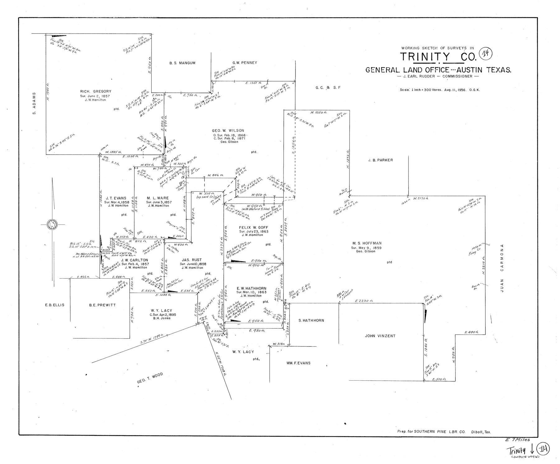
Trinity County Working Sketch 14
-
Map/Doc
69463
-
Collection
General Map Collection
-
Object Dates
8/11/1956 (Creation Date)
-
People and Organizations
Otto G. Kurio (Draftsman)
-
Counties
Trinity
-
Subjects
Surveying Working Sketch
-
Height x Width
24.8 x 29.9 inches
63.0 x 76.0 cm
-
Scale
1" = 300 varas
Part of: General Map Collection
Cooke County Sketch File 11

Print $4.00
- Digital $50.00
Cooke County Sketch File 11
1858
Size 12.4 x 8.2 inches
Map/Doc 19244
Kerr County Boundary File 4a

Print $16.00
- Digital $50.00
Kerr County Boundary File 4a
Size 6.1 x 8.2 inches
Map/Doc 64801
Young County Sketch File 5

Print $40.00
- Digital $50.00
Young County Sketch File 5
1855
Size 12.8 x 15.6 inches
Map/Doc 49662
Jefferson County Sketch File 24

Print $6.00
- Digital $50.00
Jefferson County Sketch File 24
Size 10.8 x 6.8 inches
Map/Doc 28181
Map of Colorado County

Print $20.00
- Digital $50.00
Map of Colorado County
1864
Size 22.1 x 25.0 inches
Map/Doc 3423
Hardin County Working Sketch 44

Print $40.00
- Digital $50.00
Hardin County Working Sketch 44
1954
Size 53.2 x 39.9 inches
Map/Doc 65610
Flight Mission No. DIX-3P, Frame 133, Aransas County

Print $20.00
- Digital $50.00
Flight Mission No. DIX-3P, Frame 133, Aransas County
1956
Size 17.8 x 21.1 inches
Map/Doc 83763
Gregg County Working Sketch 17

Print $20.00
- Digital $50.00
Gregg County Working Sketch 17
1950
Size 29.7 x 26.2 inches
Map/Doc 63284
Presidio County Working Sketch 60

Print $20.00
- Digital $50.00
Presidio County Working Sketch 60
1957
Size 21.9 x 18.4 inches
Map/Doc 71737
Jefferson County Sketch File 49

Print $40.00
- Digital $50.00
Jefferson County Sketch File 49
1955
Size 51.1 x 29.0 inches
Map/Doc 10508
Terrell County Working Sketch 35

Print $20.00
- Digital $50.00
Terrell County Working Sketch 35
1948
Size 38.4 x 42.2 inches
Map/Doc 62127
[Sketch for Mineral Application 1112 - Colorado River, H. E. Chambers]
![65638, [Sketch for Mineral Application 1112 - Colorado River, H. E. Chambers], General Map Collection](https://historictexasmaps.com/wmedia_w700/maps/65638.tif.jpg)
Print $20.00
- Digital $50.00
[Sketch for Mineral Application 1112 - Colorado River, H. E. Chambers]
1918
Size 17.5 x 28.2 inches
Map/Doc 65638
You may also like
Brewster County Rolled Sketch 92

Print $20.00
- Digital $50.00
Brewster County Rolled Sketch 92
1950
Size 24.3 x 15.2 inches
Map/Doc 5250
Amistad International Reservoir on Rio Grande 83

Print $20.00
- Digital $50.00
Amistad International Reservoir on Rio Grande 83
1949
Size 28.5 x 40.3 inches
Map/Doc 75512
Flight Mission No. DQN-2K, Frame 140, Calhoun County

Print $20.00
- Digital $50.00
Flight Mission No. DQN-2K, Frame 140, Calhoun County
1953
Size 17.2 x 15.9 inches
Map/Doc 84309
A true copy of Peck's field book page 1, except classification of lands

Print $2.00
- Digital $50.00
A true copy of Peck's field book page 1, except classification of lands
1876
Size 5.3 x 12.0 inches
Map/Doc 91979
Roberts County Working Sketch 12

Print $20.00
- Digital $50.00
Roberts County Working Sketch 12
Size 25.5 x 22.5 inches
Map/Doc 63538
Montgomery Co.

Print $40.00
- Digital $50.00
Montgomery Co.
1943
Size 45.2 x 54.8 inches
Map/Doc 95594
Presidio County Sketch File 52

Print $10.00
- Digital $50.00
Presidio County Sketch File 52
1921
Size 11.5 x 8.8 inches
Map/Doc 34605
Pecos County Rolled Sketch 64

Print $20.00
- Digital $50.00
Pecos County Rolled Sketch 64
Size 16.4 x 26.5 inches
Map/Doc 7235
Corpus Christi Bay in Nueces County, showing Subdivision for Mineral Development

Print $40.00
- Digital $50.00
Corpus Christi Bay in Nueces County, showing Subdivision for Mineral Development
1950
Size 48.4 x 36.0 inches
Map/Doc 1917
The Lower Valley of the Rio Grande Irrigated Farm Lands

Print $20.00
- Digital $50.00
The Lower Valley of the Rio Grande Irrigated Farm Lands
1918
Size 24.6 x 18.6 inches
Map/Doc 96729
Archer County Boundary File 7

Print $10.00
- Digital $50.00
Archer County Boundary File 7
Size 8.2 x 5.2 inches
Map/Doc 50116
Parker County Sketch File 15

Print $4.00
- Digital $50.00
Parker County Sketch File 15
1861
Size 8.3 x 8.0 inches
Map/Doc 33548