Polk County Sketch File 30a
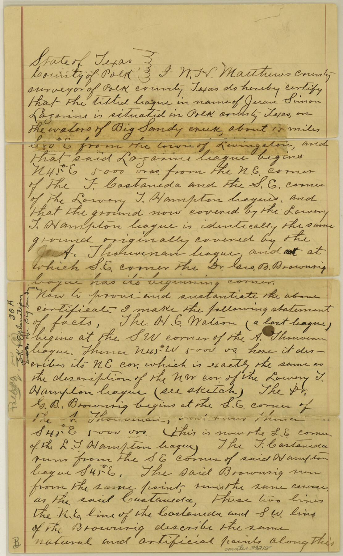
[Sketch and explanation on Big Sandy Creek]
-
Map/Doc
34215
-
Collection
General Map Collection
-
Object Dates
12/1/1891 (File Date)
-
People and Organizations
W.H. Matthews (Surveyor/Engineer)
-
Counties
Polk
-
Subjects
Surveying Sketch File
-
Height x Width
14.2 x 8.8 inches
36.1 x 22.4 cm
-
Medium
paper, manuscript
-
Features
Big Sandy Creek
Coshatta Village
Trace from Coshatta Indian Village to Nacogdoches
Part of: General Map Collection
Polk County Sketch File 29

Print $4.00
- Digital $50.00
Polk County Sketch File 29
Size 8.8 x 12.6 inches
Map/Doc 34200
Northwest Part Pecos County

Print $20.00
- Digital $50.00
Northwest Part Pecos County
1975
Size 43.4 x 44.2 inches
Map/Doc 95612
Eastland County Sketch File 4

Print $4.00
- Digital $50.00
Eastland County Sketch File 4
1861
Size 11.8 x 6.9 inches
Map/Doc 21568
Map of Young County

Print $20.00
- Digital $50.00
Map of Young County
1880
Size 22.0 x 20.3 inches
Map/Doc 4174
Hall County Sketch File 14

Print $20.00
- Digital $50.00
Hall County Sketch File 14
1882
Size 20.9 x 32.9 inches
Map/Doc 11607
Flight Mission No. DQN-6K, Frame 16, Calhoun County

Print $20.00
- Digital $50.00
Flight Mission No. DQN-6K, Frame 16, Calhoun County
1953
Size 18.7 x 22.2 inches
Map/Doc 84438
Donley County Working Sketch 4

Print $20.00
- Digital $50.00
Donley County Working Sketch 4
1958
Size 44.0 x 39.8 inches
Map/Doc 68737
Right of Way and Track Map of The Wichita Falls & Southern Railroad Company

Print $40.00
- Digital $50.00
Right of Way and Track Map of The Wichita Falls & Southern Railroad Company
1942
Size 24.6 x 56.1 inches
Map/Doc 64518
Pecos County Sketch File 27A

Print $20.00
- Digital $50.00
Pecos County Sketch File 27A
Size 26.7 x 19.8 inches
Map/Doc 12166
Hemphill County Working Sketch 30

Print $40.00
- Digital $50.00
Hemphill County Working Sketch 30
1974
Size 52.5 x 26.7 inches
Map/Doc 66125
Runnels County Sketch File 6a

Print $4.00
Runnels County Sketch File 6a
1883
Size 12.9 x 8.2 inches
Map/Doc 35442
San Jacinto County Rolled Sketch 10A

Print $40.00
- Digital $50.00
San Jacinto County Rolled Sketch 10A
1944
Size 42.9 x 59.0 inches
Map/Doc 9882
You may also like
Colorado County Sketch File 23

Print $4.00
- Digital $50.00
Colorado County Sketch File 23
1882
Size 8.8 x 8.3 inches
Map/Doc 18961
Victoria County Working Sketch 4

Print $20.00
- Digital $50.00
Victoria County Working Sketch 4
1944
Size 37.0 x 47.6 inches
Map/Doc 72274
Outer Continental Shelf Leasing Maps (Texas Offshore Operations)

Print $20.00
- Digital $50.00
Outer Continental Shelf Leasing Maps (Texas Offshore Operations)
Size 17.7 x 14.1 inches
Map/Doc 75855
Webb County Working Sketch 37

Print $20.00
- Digital $50.00
Webb County Working Sketch 37
1940
Size 25.0 x 20.4 inches
Map/Doc 72402
General Highway Map, Cameron County, Texas

Print $20.00
General Highway Map, Cameron County, Texas
1940
Size 18.5 x 25.3 inches
Map/Doc 79039
Flight Mission No. DCL-5C, Frame 48, Kenedy County

Print $20.00
- Digital $50.00
Flight Mission No. DCL-5C, Frame 48, Kenedy County
1943
Size 18.6 x 22.2 inches
Map/Doc 85844
Comanche County Boundary File 2c

Print $8.00
- Digital $50.00
Comanche County Boundary File 2c
Size 14.3 x 8.9 inches
Map/Doc 51796
Part of the boundary between the United States and Texas; north of Sabine River from the 36th to the 72nd mile mound

Print $3.00
- Digital $50.00
Part of the boundary between the United States and Texas; north of Sabine River from the 36th to the 72nd mile mound
1842
Size 12.0 x 8.8 inches
Map/Doc 93770
Foard County Rolled Sketch 14 1/2

Print $20.00
- Digital $50.00
Foard County Rolled Sketch 14 1/2
1888
Size 20.8 x 37.4 inches
Map/Doc 5889
Robertson County Rolled Sketch 5

Print $20.00
- Digital $50.00
Robertson County Rolled Sketch 5
1976
Size 34.1 x 36.4 inches
Map/Doc 9864
Flight Mission No. BQR-13K, Frame 22, Brazoria County

Print $20.00
- Digital $50.00
Flight Mission No. BQR-13K, Frame 22, Brazoria County
1952
Size 18.9 x 22.4 inches
Map/Doc 84070
Houston & Texas Central Railway Through Bastrop County

Print $40.00
- Digital $50.00
Houston & Texas Central Railway Through Bastrop County
1916
Size 21.3 x 116.5 inches
Map/Doc 64418