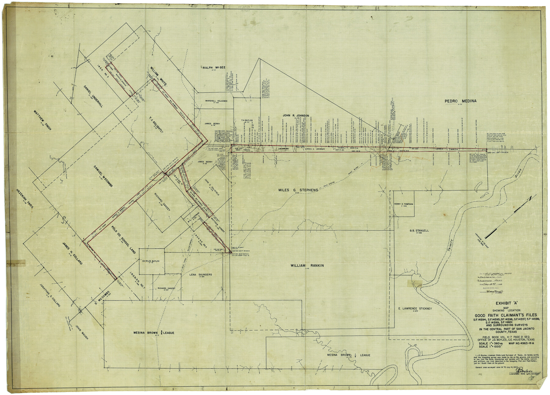
San Jacinto County Rolled Sketch 10A
Central Part of San Jacinto County, Texas
-
Map/Doc
9882
-
Collection
General Map Collection
-
Object Dates
7/14/1944 (Creation Date)
7/14/1944 (File Date)
-
People and Organizations
J.S. Boyles (Surveyor/Engineer)
-
Counties
San Jacinto
-
Subjects
Surveying Rolled Sketch
-
Height x Width
42.9 x 59.0 inches
109.0 x 149.9 cm
Part of: General Map Collection
Flight Mission No. CUG-3P, Frame 194, Kleberg County

Print $20.00
- Digital $50.00
Flight Mission No. CUG-3P, Frame 194, Kleberg County
1956
Size 18.4 x 22.2 inches
Map/Doc 86298
Pecos County Rolled Sketch 188

Print $40.00
- Digital $50.00
Pecos County Rolled Sketch 188
1984
Size 59.4 x 43.5 inches
Map/Doc 9753
Bowie County Sketch File 7e

Print $10.00
- Digital $50.00
Bowie County Sketch File 7e
1927
Size 10.5 x 8.4 inches
Map/Doc 14867
Map of Concho County

Print $20.00
- Digital $50.00
Map of Concho County
1862
Size 21.7 x 18.2 inches
Map/Doc 3435
Ward County Rolled Sketch 24E

Print $40.00
- Digital $50.00
Ward County Rolled Sketch 24E
1967
Size 42.3 x 64.9 inches
Map/Doc 10116
Bastrop County Boundary File 1

Print $4.00
- Digital $50.00
Bastrop County Boundary File 1
Size 12.6 x 8.3 inches
Map/Doc 50313
Flight Mission No. DQO-3K, Frame 20, Galveston County

Print $20.00
- Digital $50.00
Flight Mission No. DQO-3K, Frame 20, Galveston County
1952
Size 18.8 x 22.6 inches
Map/Doc 85061
Webb County Sketch File 60

Print $8.00
- Digital $50.00
Webb County Sketch File 60
1943
Size 14.4 x 8.9 inches
Map/Doc 39855
Hutchinson County Sketch File 45

Print $22.00
- Digital $50.00
Hutchinson County Sketch File 45
1991
Size 11.1 x 8.8 inches
Map/Doc 27354
Foard County Boundary File 4a

Print $40.00
- Digital $50.00
Foard County Boundary File 4a
Size 16.9 x 45.4 inches
Map/Doc 53522
Jones County Sketch File 8

Print $20.00
- Digital $50.00
Jones County Sketch File 8
Size 18.5 x 22.8 inches
Map/Doc 11898
Aransas County Working Sketch 19

Print $20.00
- Digital $50.00
Aransas County Working Sketch 19
1978
Size 25.1 x 31.1 inches
Map/Doc 67186
You may also like
Collin County Sketch File 13

Print $4.00
- Digital $50.00
Collin County Sketch File 13
1874
Size 8.8 x 6.8 inches
Map/Doc 18872
Edwards County Working Sketch 107

Print $40.00
- Digital $50.00
Edwards County Working Sketch 107
1972
Size 54.5 x 38.8 inches
Map/Doc 68983
Bailey County Sketch File 4

Print $8.00
- Digital $50.00
Bailey County Sketch File 4
1907
Size 14.2 x 8.7 inches
Map/Doc 13954
Flight Mission No. CRK-8P, Frame 120, Refugio County

Print $20.00
- Digital $50.00
Flight Mission No. CRK-8P, Frame 120, Refugio County
1956
Size 18.4 x 22.1 inches
Map/Doc 86975
San Saba County

Print $20.00
- Digital $50.00
San Saba County
1877
Size 20.2 x 22.0 inches
Map/Doc 4020
Angelina County Sketch File 15

Print $8.00
- Digital $50.00
Angelina County Sketch File 15
1848
Size 12.5 x 7.5 inches
Map/Doc 12960
[G. & M. Block 5]
![91796, [G. & M. Block 5], Twichell Survey Records](https://historictexasmaps.com/wmedia_w700/maps/91796-1.tif.jpg)
Print $20.00
- Digital $50.00
[G. & M. Block 5]
Size 22.6 x 18.9 inches
Map/Doc 91796
Carson County Boundary File 10

Print $2.00
- Digital $50.00
Carson County Boundary File 10
Size 11.5 x 7.2 inches
Map/Doc 51185
Cherokee County Sketch File 6

Print $22.00
- Digital $50.00
Cherokee County Sketch File 6
1852
Size 12.4 x 16.4 inches
Map/Doc 18126
Amistad International Reservoir on Rio Grande 95a

Print $20.00
- Digital $50.00
Amistad International Reservoir on Rio Grande 95a
1950
Size 28.8 x 41.2 inches
Map/Doc 75526
North Sulphur River, Ben Franklin Sheet

Print $20.00
- Digital $50.00
North Sulphur River, Ben Franklin Sheet
1928
Size 14.2 x 30.0 inches
Map/Doc 78324
