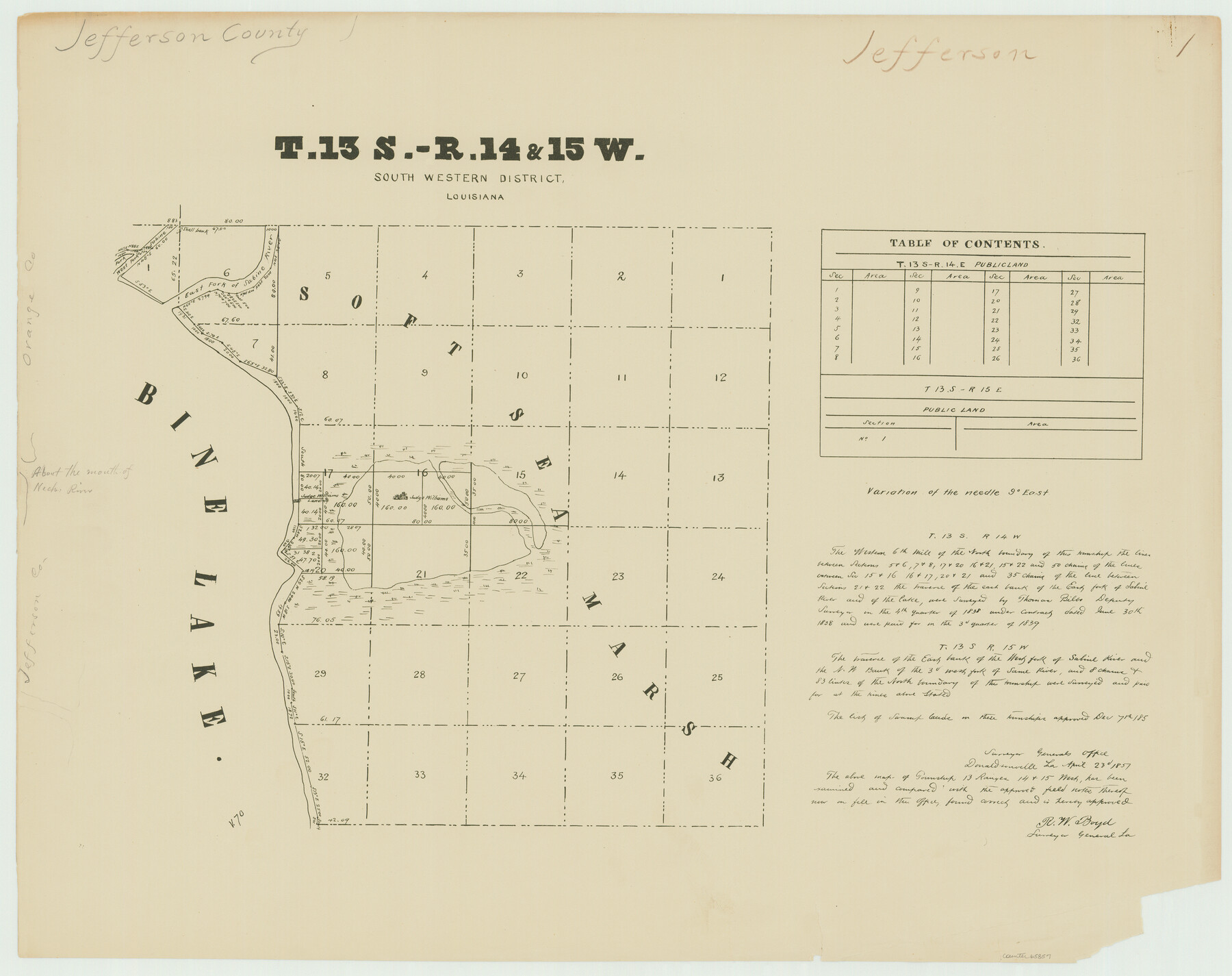
Township 13 South Ranges 14 and 15 West, South Western District, Louisiana
Louisiana Land Surveys Across From Jefferson County, Texas 1
-
Map/Doc
65857
-
Collection
General Map Collection
-
Object Dates
1838 (Creation Date)
-
People and Organizations
Surveyor General's Office Louisiana (Publisher)
Thomas Bilbo (Surveyor/Engineer)
-
Subjects
Texas Boundaries
-
Height x Width
19.6 x 24.8 inches
49.8 x 63.0 cm
Part of: General Map Collection
Kent County Working Sketch 14

Print $20.00
- Digital $50.00
Kent County Working Sketch 14
1965
Size 28.2 x 35.4 inches
Map/Doc 70021
Bowie County Working Sketch 20

Print $20.00
- Digital $50.00
Bowie County Working Sketch 20
1965
Size 33.0 x 31.9 inches
Map/Doc 67424
Presidio County Working Sketch 97

Print $20.00
- Digital $50.00
Presidio County Working Sketch 97
1978
Size 28.2 x 28.0 inches
Map/Doc 71774
Collin County Working Sketch 1

Print $20.00
- Digital $50.00
Collin County Working Sketch 1
1921
Size 26.6 x 23.4 inches
Map/Doc 68095
Current Miscellaneous File 53

Print $8.00
- Digital $50.00
Current Miscellaneous File 53
1945
Size 12.0 x 9.1 inches
Map/Doc 74038
Young County Rolled Sketch 14

Print $20.00
- Digital $50.00
Young County Rolled Sketch 14
1967
Size 17.7 x 22.7 inches
Map/Doc 8302
La Salle County Working Sketch 44

Print $40.00
- Digital $50.00
La Salle County Working Sketch 44
1980
Size 34.7 x 65.8 inches
Map/Doc 70345
Castro County Sketch File 3

Print $4.00
- Digital $50.00
Castro County Sketch File 3
1902
Size 11.2 x 8.9 inches
Map/Doc 17458
Hardeman County Rolled Sketch 15

Print $20.00
- Digital $50.00
Hardeman County Rolled Sketch 15
1890
Size 18.0 x 23.0 inches
Map/Doc 6072
Carte Reduit d'une partie des Côtes des Isles Australes

Print $20.00
- Digital $50.00
Carte Reduit d'une partie des Côtes des Isles Australes
1782
Size 12.7 x 17.3 inches
Map/Doc 97122
Angelina County Sketch File 15b

Print $8.00
- Digital $50.00
Angelina County Sketch File 15b
1863
Size 12.7 x 7.9 inches
Map/Doc 12968
Planiglobii Terrestris Mappa Universalis Utrumqs Hemisphaerium Orient et Occidentale

Print $20.00
- Digital $50.00
Planiglobii Terrestris Mappa Universalis Utrumqs Hemisphaerium Orient et Occidentale
1746
Size 21.4 x 24.4 inches
Map/Doc 96580
You may also like
Burleson County Working Sketch 30

Print $20.00
- Digital $50.00
Burleson County Working Sketch 30
1981
Size 37.4 x 26.9 inches
Map/Doc 67749
Winkler Co., Tex., standard single county oil development survey

Print $20.00
- Digital $50.00
Winkler Co., Tex., standard single county oil development survey
Size 14.5 x 16.4 inches
Map/Doc 91972
Working Sketch in Dickens and Crosby Cos.

Print $20.00
- Digital $50.00
Working Sketch in Dickens and Crosby Cos.
1910
Size 36.1 x 24.8 inches
Map/Doc 10771
Concho County Working Sketch 15

Print $20.00
- Digital $50.00
Concho County Working Sketch 15
1955
Size 25.2 x 30.8 inches
Map/Doc 68197
Collin County Sketch File 9

Print $4.00
- Digital $50.00
Collin County Sketch File 9
1878
Size 8.3 x 10.1 inches
Map/Doc 18870
Map of Llano County

Print $20.00
- Digital $50.00
Map of Llano County
1877
Size 19.9 x 25.7 inches
Map/Doc 3824
Ft. W. & R. G. Ry. Right of Way Map, Chapin to Bluffdale, Hood County, Texas

Print $40.00
- Digital $50.00
Ft. W. & R. G. Ry. Right of Way Map, Chapin to Bluffdale, Hood County, Texas
1918
Size 36.5 x 50.5 inches
Map/Doc 64645
Intracoastal Waterway - Port Arthur to Galveston Bay

Print $20.00
- Digital $50.00
Intracoastal Waterway - Port Arthur to Galveston Bay
1957
Size 27.0 x 38.6 inches
Map/Doc 69830
El Paso County Rolled Sketch 47

Print $40.00
- Digital $50.00
El Paso County Rolled Sketch 47
1885
Size 41.3 x 90.4 inches
Map/Doc 8874
Dietzgen "Federal" 986 Proportional Divider Drafting Tool

Dietzgen "Federal" 986 Proportional Divider Drafting Tool
Size 1.0 x 8.3 inches
Map/Doc 97307

Crockett County Sketch File 57

Print $22.00
- Digital $50.00
Crockett County Sketch File 57
Size 12.2 x 8.9 inches
Map/Doc 19832