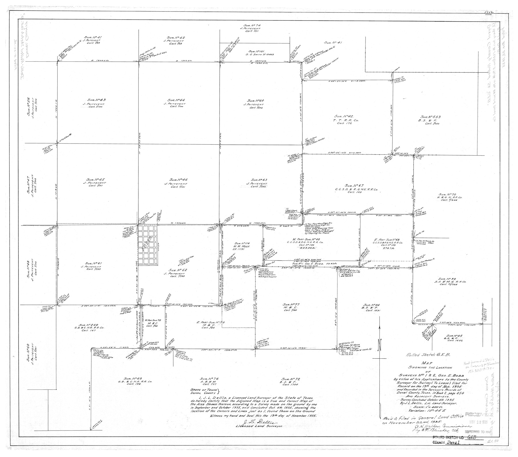
Duval County Rolled Sketch GEB
Map showing the location of surveys nos. 1 & 2, Geo. E. Bobb
-
Map/Doc
5768
-
Collection
General Map Collection
-
Object Dates
1935/10/4 (Survey Date)
1935/11/22 (File Date)
1935/11/19 (Creation Date)
-
People and Organizations
J.L. Dellis (Surveyor/Engineer)
-
Counties
Duval
-
Subjects
Surveying Rolled Sketch
-
Height x Width
26.9 x 30.4 inches
68.3 x 77.2 cm
-
Scale
1" = 400 varas
Part of: General Map Collection
Fractional Township No. 7 South Range No. 6 East of the Indian Meridian, Indian Territory

Print $20.00
- Digital $50.00
Fractional Township No. 7 South Range No. 6 East of the Indian Meridian, Indian Territory
1898
Size 19.2 x 24.3 inches
Map/Doc 75211
Burnet County Sketch File 29

Print $4.00
- Digital $50.00
Burnet County Sketch File 29
1874
Size 10.1 x 8.1 inches
Map/Doc 16744
Hudspeth County Working Sketch 26

Print $40.00
- Digital $50.00
Hudspeth County Working Sketch 26
1972
Size 31.5 x 54.0 inches
Map/Doc 66308
Delta County Sketch File 1a

Print $4.00
- Digital $50.00
Delta County Sketch File 1a
Size 8.3 x 8.9 inches
Map/Doc 20668
Starr County Sketch File D

Print $8.00
- Digital $50.00
Starr County Sketch File D
1892
Size 14.2 x 8.7 inches
Map/Doc 36915
Cherokee County Boundary File 6 and 15

Print $8.00
- Digital $50.00
Cherokee County Boundary File 6 and 15
Size 8.3 x 6.7 inches
Map/Doc 51301
Deaf Smith County Working Sketch 4

Print $40.00
- Digital $50.00
Deaf Smith County Working Sketch 4
1983
Size 37.0 x 52.4 inches
Map/Doc 68644
Hansford County Boundary File 2

Print $14.00
- Digital $50.00
Hansford County Boundary File 2
Size 9.3 x 4.9 inches
Map/Doc 54245
Johnson County Working Sketch 31

Print $20.00
- Digital $50.00
Johnson County Working Sketch 31
2007
Size 21.2 x 22.0 inches
Map/Doc 87499
Lynn County Rolled Sketch WR

Print $20.00
- Digital $50.00
Lynn County Rolled Sketch WR
Size 14.7 x 23.8 inches
Map/Doc 6656
Scurry County Working Sketch 7

Print $20.00
- Digital $50.00
Scurry County Working Sketch 7
1971
Size 33.5 x 29.0 inches
Map/Doc 63836
Outer Continental Shelf Leasing Maps (Texas Offshore Operations)

Print $20.00
- Digital $50.00
Outer Continental Shelf Leasing Maps (Texas Offshore Operations)
Size 17.7 x 14.1 inches
Map/Doc 75855
You may also like
Missouri, Kansas, & Texas Ry.

Print $20.00
- Digital $50.00
Missouri, Kansas, & Texas Ry.
Size 6.7 x 5.4 inches
Map/Doc 96598
General Highway Map. Detail of Cities and Towns in Wharton County, Texas

Print $20.00
General Highway Map. Detail of Cities and Towns in Wharton County, Texas
1961
Size 18.3 x 24.8 inches
Map/Doc 79707
Padre Island National Seashore

Print $4.00
- Digital $50.00
Padre Island National Seashore
Size 16.2 x 22.1 inches
Map/Doc 60534
Sketch G Showing the Progress of the Survey in Section VII From 1849 to 1852

Print $20.00
- Digital $50.00
Sketch G Showing the Progress of the Survey in Section VII From 1849 to 1852
1852
Size 13.6 x 25.8 inches
Map/Doc 97219
Ellis County Working Sketch 3

Print $40.00
- Digital $50.00
Ellis County Working Sketch 3
1981
Size 39.1 x 50.0 inches
Map/Doc 69019
Crockett County Rolled Sketch Z

Print $20.00
- Digital $50.00
Crockett County Rolled Sketch Z
Size 38.7 x 36.1 inches
Map/Doc 76182
Flight Mission No. BQR-20K, Frame 13, Brazoria County

Print $20.00
- Digital $50.00
Flight Mission No. BQR-20K, Frame 13, Brazoria County
1952
Size 18.6 x 22.3 inches
Map/Doc 84115
Hutchinson County Rolled Sketch 43

Print $40.00
- Digital $50.00
Hutchinson County Rolled Sketch 43
1992
Size 41.3 x 50.0 inches
Map/Doc 6314
Bandera County Working Sketch 42

Print $20.00
- Digital $50.00
Bandera County Working Sketch 42
1978
Size 26.9 x 29.8 inches
Map/Doc 67638
[Galveston, Harrisburg & San Antonio through El Paso County]
![64005, [Galveston, Harrisburg & San Antonio through El Paso County], General Map Collection](https://historictexasmaps.com/wmedia_w700/maps/64005.tif.jpg)
Print $20.00
- Digital $50.00
[Galveston, Harrisburg & San Antonio through El Paso County]
1906
Size 13.3 x 33.6 inches
Map/Doc 64005
Lipscomb County Rolled Sketch 5

Print $40.00
- Digital $50.00
Lipscomb County Rolled Sketch 5
Size 60.5 x 8.0 inches
Map/Doc 81427
Travis County Sketch File 69A

Print $20.00
- Digital $50.00
Travis County Sketch File 69A
Size 18.0 x 20.9 inches
Map/Doc 12476