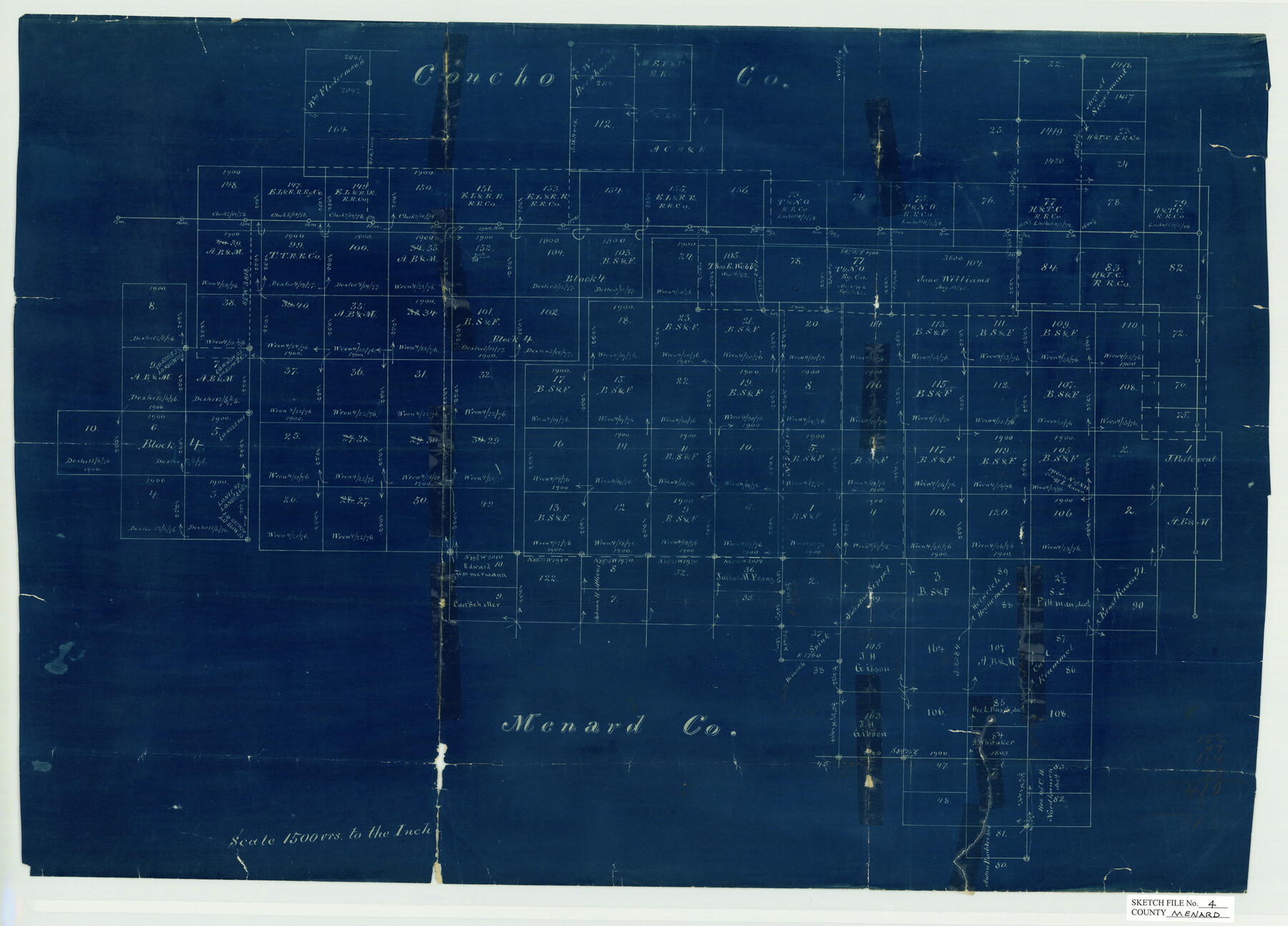
Menard County Sketch File 4
Block 4, Menard County, Texas
-
Map/Doc
12072
-
Collection
General Map Collection
-
People and Organizations
F. von Rosenberg (Surveyor/Engineer)
-
Counties
Menard Concho McCulloch
-
Subjects
Surveying Sketch File
-
Height x Width
18.3 x 25.5 inches
46.5 x 64.8 cm
-
Medium
blueprint/diazo
-
Scale
1" = 1500 varas
Part of: General Map Collection
Matagorda County Sketch File 46

Print $107.00
- Digital $50.00
Matagorda County Sketch File 46
1985
Size 11.2 x 8.5 inches
Map/Doc 30932
Oldham County Boundary File 3

Print $80.00
- Digital $50.00
Oldham County Boundary File 3
Size 20.0 x 58.0 inches
Map/Doc 57771
Schleicher County Sketch File 13

Print $10.00
- Digital $50.00
Schleicher County Sketch File 13
1916
Size 14.4 x 8.9 inches
Map/Doc 36493

Flight Mission No. DAG-21K, Frame 28, Matagorda County

Print $20.00
- Digital $50.00
Flight Mission No. DAG-21K, Frame 28, Matagorda County
1952
Size 18.6 x 22.4 inches
Map/Doc 86395
Webb County Sketch File 64

Print $20.00
- Digital $50.00
Webb County Sketch File 64
1948
Size 23.1 x 30.6 inches
Map/Doc 12654
San Jacinto County Working Sketch 40

Print $40.00
- Digital $50.00
San Jacinto County Working Sketch 40
1971
Size 43.9 x 59.8 inches
Map/Doc 63753
Travis County Sketch File 76

Print $68.00
- Digital $50.00
Travis County Sketch File 76
1996
Size 11.4 x 8.9 inches
Map/Doc 38474
Donley County Sketch File 1a

Print $20.00
- Digital $50.00
Donley County Sketch File 1a
Size 23.6 x 16.6 inches
Map/Doc 11362
Rusk County Rolled Sketch 3

Print $20.00
- Digital $50.00
Rusk County Rolled Sketch 3
Size 21.8 x 38.2 inches
Map/Doc 7542
Rosebud Station Map -Tracks and Structures - Lands, San Antonio and Aransas Pass Railway Co

Print $4.00
- Digital $50.00
Rosebud Station Map -Tracks and Structures - Lands, San Antonio and Aransas Pass Railway Co
1919
Size 11.7 x 18.6 inches
Map/Doc 62565
Fayette County

Print $40.00
- Digital $50.00
Fayette County
1920
Size 42.7 x 49.8 inches
Map/Doc 4945
You may also like
Zavala County Working Sketch 4

Print $20.00
- Digital $50.00
Zavala County Working Sketch 4
1936
Size 21.1 x 23.4 inches
Map/Doc 62079
Richardson's New Map of the State of Texas prepared for the Texas Almanac

Print $20.00
- Digital $50.00
Richardson's New Map of the State of Texas prepared for the Texas Almanac
1873
Size 19.8 x 27.1 inches
Map/Doc 96873
Hamilton County Sketch File 2

Print $4.00
- Digital $50.00
Hamilton County Sketch File 2
1854
Size 12.2 x 7.9 inches
Map/Doc 24899
Working Sketch in Dickens and Crosby Cos.

Print $20.00
- Digital $50.00
Working Sketch in Dickens and Crosby Cos.
1910
Size 36.1 x 24.8 inches
Map/Doc 10771
Brazos River, Brazos River Sheet 1

Print $4.00
- Digital $50.00
Brazos River, Brazos River Sheet 1
1926
Size 21.5 x 25.4 inches
Map/Doc 65293
Zavala County Sketch File 34

Print $4.00
- Digital $50.00
Zavala County Sketch File 34
1887
Size 13.0 x 8.5 inches
Map/Doc 41395
San Patricio County Rolled Sketch 54

Print $20.00
- Digital $50.00
San Patricio County Rolled Sketch 54
1995
Size 25.3 x 36.5 inches
Map/Doc 7740
Maps & Lists Showing Prison Lands (Oil & Gas) Leased as of June 1955

Digital $50.00
Maps & Lists Showing Prison Lands (Oil & Gas) Leased as of June 1955
Size 11.1 x 9.0 inches
Map/Doc 62872
Surveys of Hutchins Stock Assn. Lse.

Print $20.00
- Digital $50.00
Surveys of Hutchins Stock Assn. Lse.
1929
Size 41.3 x 21.1 inches
Map/Doc 92817
Maverick County Working Sketch 7

Print $20.00
- Digital $50.00
Maverick County Working Sketch 7
1959
Size 22.4 x 21.0 inches
Map/Doc 70899
[Surveys in the Robertson District along the Trinity River and Richland Creek]
![104, [Surveys in the Robertson District along the Trinity River and Richland Creek], General Map Collection](https://historictexasmaps.com/wmedia_w700/maps/104.tif.jpg)
Print $20.00
- Digital $50.00
[Surveys in the Robertson District along the Trinity River and Richland Creek]
1841
Size 15.3 x 12.2 inches
Map/Doc 104
Fisher County Sketch File 10

Print $20.00
- Digital $50.00
Fisher County Sketch File 10
Size 9.7 x 37.0 inches
Map/Doc 11477