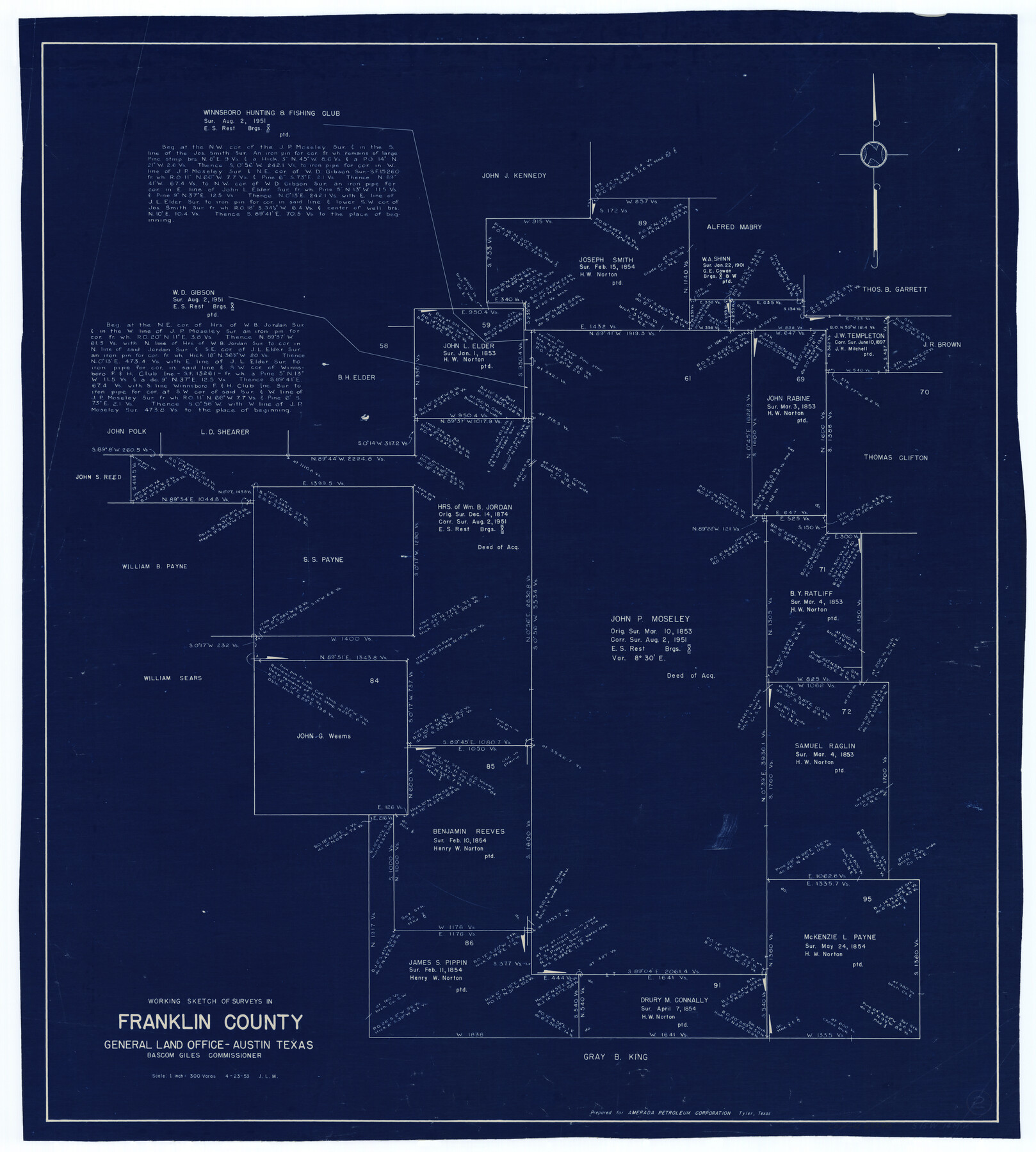
Franklin County Working Sketch 2
-
Map/Doc
69240
-
Collection
General Map Collection
-
Object Dates
4/23/1953 (Creation Date)
-
Counties
Franklin
-
Subjects
Surveying Working Sketch
-
Height x Width
33.3 x 29.9 inches
84.6 x 76.0 cm
-
Scale
1" = 300 varas
Part of: General Map Collection
Lamar County Texas

Print $20.00
- Digital $50.00
Lamar County Texas
1879
Size 23.4 x 18.3 inches
Map/Doc 3784
Map of the Houston and Great Northern R.R. from Trinity River to Palestine

Print $40.00
- Digital $50.00
Map of the Houston and Great Northern R.R. from Trinity River to Palestine
1872
Size 30.3 x 119.9 inches
Map/Doc 64549
Flight Mission No. CGI-3N, Frame 73, Cameron County

Print $20.00
- Digital $50.00
Flight Mission No. CGI-3N, Frame 73, Cameron County
1954
Size 18.4 x 22.4 inches
Map/Doc 84567
Ellis County Sketch File 15

Print $40.00
- Digital $50.00
Ellis County Sketch File 15
1861
Size 15.7 x 12.5 inches
Map/Doc 21856
Culberson County Rolled Sketch 59

Print $40.00
- Digital $50.00
Culberson County Rolled Sketch 59
1974
Size 37.3 x 78.1 inches
Map/Doc 8760
Capitol Grounds, Austin

Print $20.00
- Digital $50.00
Capitol Grounds, Austin
Size 35.4 x 40.5 inches
Map/Doc 16955
Presidio County Rolled Sketch T-2

Print $40.00
- Digital $50.00
Presidio County Rolled Sketch T-2
Size 29.9 x 65.1 inches
Map/Doc 9804
Wise County Sketch File 2a

Print $4.00
- Digital $50.00
Wise County Sketch File 2a
1856
Size 12.3 x 8.1 inches
Map/Doc 40526
Culberson County Rolled Sketch X1

Print $20.00
- Digital $50.00
Culberson County Rolled Sketch X1
1896
Size 20.1 x 20.1 inches
Map/Doc 5684
Flight Mission No. DIX-8P, Frame 60, Aransas County

Print $20.00
- Digital $50.00
Flight Mission No. DIX-8P, Frame 60, Aransas County
1956
Size 18.5 x 22.2 inches
Map/Doc 83891
Grayson County Working Sketch 16

Print $20.00
- Digital $50.00
Grayson County Working Sketch 16
1954
Size 44.2 x 24.7 inches
Map/Doc 63255

You may also like
Medina County Working Sketch 29

Print $20.00
- Digital $50.00
Medina County Working Sketch 29
Size 40.1 x 25.0 inches
Map/Doc 70944
Pecos County Rolled Sketch 179

Print $20.00
- Digital $50.00
Pecos County Rolled Sketch 179
1980
Size 28.0 x 28.2 inches
Map/Doc 7299
Atascosa County Rolled Sketch 5B1

Print $20.00
- Digital $50.00
Atascosa County Rolled Sketch 5B1
Size 14.6 x 11.7 inches
Map/Doc 5090
General Highway Map, Wilbarger County, Texas

Print $20.00
General Highway Map, Wilbarger County, Texas
1961
Size 24.9 x 18.2 inches
Map/Doc 79710
Baylor County Boundary File 7

Print $6.00
- Digital $50.00
Baylor County Boundary File 7
Size 11.2 x 8.8 inches
Map/Doc 50403
United States - Gulf Coast - From Latitude 26° 33' to the Rio Grande Texas

Print $20.00
- Digital $50.00
United States - Gulf Coast - From Latitude 26° 33' to the Rio Grande Texas
1918
Size 18.3 x 24.1 inches
Map/Doc 72845
Brewster County Rolled Sketch 81

Print $20.00
- Digital $50.00
Brewster County Rolled Sketch 81
1945
Size 30.8 x 33.9 inches
Map/Doc 8494
Brazoria County Working Sketch 33

Print $20.00
- Digital $50.00
Brazoria County Working Sketch 33
1980
Size 29.6 x 35.6 inches
Map/Doc 67518
[Surveys near Brushy Creek]
![360, [Surveys near Brushy Creek], General Map Collection](https://historictexasmaps.com/wmedia_w700/maps/360.tif.jpg)
Print $2.00
- Digital $50.00
[Surveys near Brushy Creek]
1845
Size 10.0 x 7.9 inches
Map/Doc 360
Hartley County Sketch File 16

Print $4.00
- Digital $50.00
Hartley County Sketch File 16
Size 11.1 x 7.1 inches
Map/Doc 26113
Marshall Ford Dam right of way survey, General Ownership Map

Print $40.00
- Digital $50.00
Marshall Ford Dam right of way survey, General Ownership Map
1942
Size 36.6 x 55.9 inches
Map/Doc 60402
Atascosa County Sketch File 25

Print $4.00
- Digital $50.00
Atascosa County Sketch File 25
Size 12.7 x 8.0 inches
Map/Doc 13792