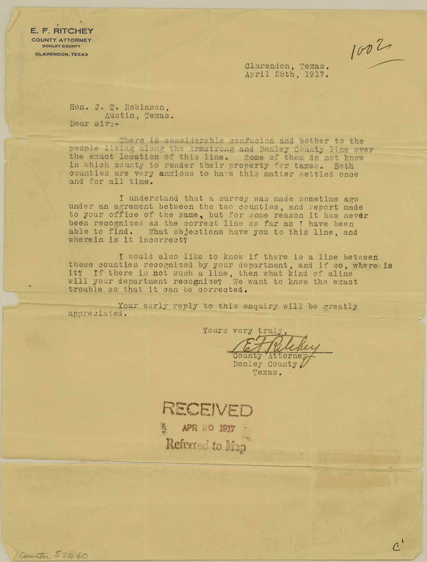
Donley County Boundary File 7
[Letter regarding the Boundary line between Donley and Armstrong Counties]
-
Map/Doc
52640
-
Collection
General Map Collection
-
Counties
Donley
-
Subjects
County Boundaries
-
Height x Width
11.3 x 8.6 inches
28.7 x 21.8 cm
Part of: General Map Collection
Parker County Working Sketch 27

Print $20.00
- Digital $50.00
Parker County Working Sketch 27
2009
Map/Doc 89001
Ector County Working Sketch 18

Print $20.00
- Digital $50.00
Ector County Working Sketch 18
1957
Size 42.0 x 39.1 inches
Map/Doc 68861
Jasper County Rolled Sketch 7B

Print $20.00
- Digital $50.00
Jasper County Rolled Sketch 7B
Size 19.7 x 11.6 inches
Map/Doc 6355
Flight Mission No. BRE-2P, Frame 111, Nueces County

Print $20.00
- Digital $50.00
Flight Mission No. BRE-2P, Frame 111, Nueces County
1956
Size 18.4 x 22.6 inches
Map/Doc 86797
Flight Mission No. DIX-10P, Frame 144, Aransas County

Print $20.00
- Digital $50.00
Flight Mission No. DIX-10P, Frame 144, Aransas County
1956
Size 18.6 x 22.3 inches
Map/Doc 83946

This is a sketch of Austin town tract

Print $2.00
- Digital $50.00
This is a sketch of Austin town tract
Size 6.5 x 8.1 inches
Map/Doc 148
Wilson County Working Sketch 2

Print $20.00
- Digital $50.00
Wilson County Working Sketch 2
1950
Size 42.0 x 42.8 inches
Map/Doc 72582
[Surveys near Hondo Creek]
![226, [Surveys near Hondo Creek], General Map Collection](https://historictexasmaps.com/wmedia_w700/maps/226.tif.jpg)
Print $2.00
- Digital $50.00
[Surveys near Hondo Creek]
1847
Size 13.8 x 8.0 inches
Map/Doc 226
Chambers County Sketch File 15

Print $4.00
- Digital $50.00
Chambers County Sketch File 15
Size 8.3 x 12.4 inches
Map/Doc 17563
Wilbarger County Sketch File 12

Print $8.00
- Digital $50.00
Wilbarger County Sketch File 12
Size 12.7 x 8.1 inches
Map/Doc 40185
Galveston County NRC Article 33.136 Sketch 49

Print $24.00
- Digital $50.00
Galveston County NRC Article 33.136 Sketch 49
2007
Size 24.0 x 36.0 inches
Map/Doc 94663
You may also like
Flight Mission No. BRA-8M, Frame 65, Jefferson County

Print $20.00
- Digital $50.00
Flight Mission No. BRA-8M, Frame 65, Jefferson County
1953
Size 18.6 x 22.4 inches
Map/Doc 85585
Pecos County Rolled Sketch 165

Print $20.00
- Digital $50.00
Pecos County Rolled Sketch 165
1966
Size 23.4 x 19.6 inches
Map/Doc 7290
Hutchinson County Rolled Sketch 44-4

Print $20.00
- Digital $50.00
Hutchinson County Rolled Sketch 44-4
2002
Size 24.0 x 36.0 inches
Map/Doc 77540
Upton County Rolled Sketch 18

Print $40.00
- Digital $50.00
Upton County Rolled Sketch 18
1933
Size 38.3 x 55.5 inches
Map/Doc 10039
Calhoun County Boundary File 5

Print $10.00
- Digital $50.00
Calhoun County Boundary File 5
Size 14.2 x 8.8 inches
Map/Doc 51009
Kerr County Working Sketch 6

Print $20.00
- Digital $50.00
Kerr County Working Sketch 6
1947
Size 32.8 x 26.3 inches
Map/Doc 70037
Official Railroad and County Map of Texas

Print $40.00
Official Railroad and County Map of Texas
1914
Size 45.8 x 48.6 inches
Map/Doc 76233
[Plat showing traverse line run from I. R. Rock at southeast corner survey 58 northerly to the I. R. Rock corner at the northeast 60]
![91598, [Plat showing traverse line run from I. R. Rock at southeast corner survey 58 northerly to the I. R. Rock corner at the northeast 60], Twichell Survey Records](https://historictexasmaps.com/wmedia_w700/maps/91598-1.tif.jpg)
Print $20.00
- Digital $50.00
[Plat showing traverse line run from I. R. Rock at southeast corner survey 58 northerly to the I. R. Rock corner at the northeast 60]
1935
Size 21.7 x 18.0 inches
Map/Doc 91598
Railroad and County Map of Texas

Print $20.00
- Digital $50.00
Railroad and County Map of Texas
1887
Size 18.0 x 23.9 inches
Map/Doc 93959
Webb County Working Sketch 13

Print $20.00
- Digital $50.00
Webb County Working Sketch 13
1922
Size 14.6 x 11.4 inches
Map/Doc 72378
Map of Leon County

Print $20.00
- Digital $50.00
Map of Leon County
1873
Size 26.2 x 21.9 inches
Map/Doc 3807
Tarrant County State Real Property Sketch 4

Print $20.00
- Digital $50.00
Tarrant County State Real Property Sketch 4
2018
Size 47.8 x 35.9 inches
Map/Doc 95403