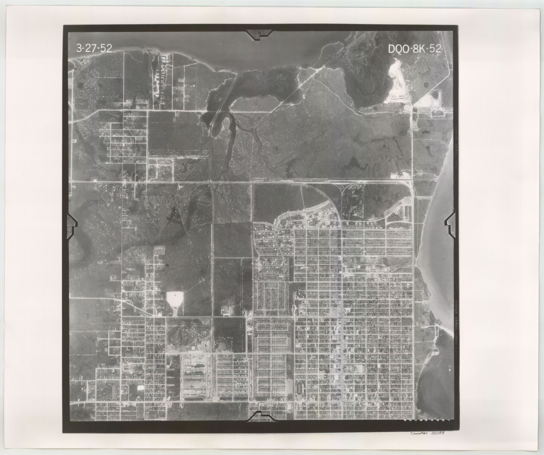
Flight Mission No. DQO-8K, Frame 52, Galveston County
DQO-8K-52
-
Map/Doc
85159
-
Collection
General Map Collection
-
Object Dates
1952/3/27 (Creation Date)
-
People and Organizations
U. S. Department of Agriculture (Publisher)
-
Counties
Galveston
-
Subjects
Aerial Photograph
-
Height x Width
18.6 x 22.2 inches
47.2 x 56.4 cm
-
Comments
Flown by Aero Exploration Company of Tulsa, Oklahoma.
Part of: General Map Collection
Dickens County Sketch File 33
![21025, Dickens County Sketch File 33, General Map Collection](https://historictexasmaps.com/wmedia_w700/pdf_converted_jpg/qi_pdf_thumbnail_10758.jpg)
Print $10.00
- Digital $50.00
Dickens County Sketch File 33
1947
Size 14.5 x 9.1 inches
Map/Doc 21025
Terry County Sketch File 6
![38026, Terry County Sketch File 6, General Map Collection](https://historictexasmaps.com/wmedia_w700/pdf_converted_jpg/qi_pdf_thumbnail_14492.jpg)
Print $8.00
- Digital $50.00
Terry County Sketch File 6
1924
Size 11.2 x 8.7 inches
Map/Doc 38026
Flight Mission No. DIX-8P, Frame 70, Aransas County
![83901, Flight Mission No. DIX-8P, Frame 70, Aransas County, General Map Collection](https://historictexasmaps.com/wmedia_w700/pdf_converted_jpg/qi_pdf_thumbnail_31119.jpg)
Print $20.00
- Digital $50.00
Flight Mission No. DIX-8P, Frame 70, Aransas County
1956
Size 18.7 x 22.4 inches
Map/Doc 83901
Val Verde County Sketch File 52
![12591, Val Verde County Sketch File 52, General Map Collection](https://historictexasmaps.com/wmedia_w700/pdf_converted_jpg/qi_pdf_thumbnail_8864.jpg)
Print $20.00
- Digital $50.00
Val Verde County Sketch File 52
1885
Size 20.4 x 21.9 inches
Map/Doc 12591
United States including territories and insular possessions showing the extent of public surveys, national parks, national forests, indian reservations, national wildlife refuges, and reclamation projects
![65795, United States including territories and insular possessions showing the extent of public surveys, national parks, national forests, indian reservations, national wildlife refuges, and reclamation projects, General Map Collection](https://historictexasmaps.com/wmedia_w700/maps/65795.tif.jpg)
Print $40.00
- Digital $50.00
United States including territories and insular possessions showing the extent of public surveys, national parks, national forests, indian reservations, national wildlife refuges, and reclamation projects
1953
Size 64.5 x 44.5 inches
Map/Doc 65795
Day Ranch Lands, Leaday, Texas
![81516, Day Ranch Lands, Leaday, Texas, General Map Collection](https://historictexasmaps.com/wmedia_w700/maps/81516.tif.jpg)
Print $20.00
- Digital $50.00
Day Ranch Lands, Leaday, Texas
1948
Size 30.8 x 23.0 inches
Map/Doc 81516
Survey of Mustang Is., Joseph's and a part of Matagorda Island.
![3183, Survey of Mustang Is., Joseph's and a part of Matagorda Island., General Map Collection](https://historictexasmaps.com/wmedia_w700/maps/3183.tif.jpg)
Print $20.00
- Digital $50.00
Survey of Mustang Is., Joseph's and a part of Matagorda Island.
1834
Size 19.5 x 20.2 inches
Map/Doc 3183
[Gulf Coast of Texas]
![72701, [Gulf Coast of Texas], General Map Collection](https://historictexasmaps.com/wmedia_w700/maps/72701.tif.jpg)
Print $20.00
- Digital $50.00
[Gulf Coast of Texas]
1881
Size 18.2 x 28.5 inches
Map/Doc 72701
Matagorda County Rolled Sketch PHL
![9476, Matagorda County Rolled Sketch PHL, General Map Collection](https://historictexasmaps.com/wmedia_w700/maps/9476.tif.jpg)
Print $20.00
- Digital $50.00
Matagorda County Rolled Sketch PHL
1937
Size 37.3 x 40.0 inches
Map/Doc 9476
Andrews County Working Sketch 27
![67073, Andrews County Working Sketch 27, General Map Collection](https://historictexasmaps.com/wmedia_w700/maps/67073.tif.jpg)
Print $20.00
- Digital $50.00
Andrews County Working Sketch 27
1984
Size 19.1 x 16.2 inches
Map/Doc 67073
Brooks County Rolled Sketch 15
![5340, Brooks County Rolled Sketch 15, General Map Collection](https://historictexasmaps.com/wmedia_w700/maps/5340.tif.jpg)
Print $20.00
- Digital $50.00
Brooks County Rolled Sketch 15
1931
Size 22.4 x 36.8 inches
Map/Doc 5340
East Part of Brewster Co.
![77219, East Part of Brewster Co., General Map Collection](https://historictexasmaps.com/wmedia_w700/maps/77219.tif.jpg)
Print $40.00
- Digital $50.00
East Part of Brewster Co.
1952
Size 48.5 x 30.7 inches
Map/Doc 77219
You may also like
Dallam County Sketch File 3
![20337, Dallam County Sketch File 3, General Map Collection](https://historictexasmaps.com/wmedia_w700/pdf_converted_jpg/qi_pdf_thumbnail_10596.jpg)
Print $4.00
- Digital $50.00
Dallam County Sketch File 3
Size 14.6 x 9.0 inches
Map/Doc 20337
[Northeast part of County]
![89957, [Northeast part of County], Twichell Survey Records](https://historictexasmaps.com/wmedia_w700/maps/89957-1.tif.jpg)
Print $20.00
- Digital $50.00
[Northeast part of County]
Size 37.1 x 42.9 inches
Map/Doc 89957
Duval County Rolled Sketch 24
![5743, Duval County Rolled Sketch 24, General Map Collection](https://historictexasmaps.com/wmedia_w700/maps/5743.tif.jpg)
Print $20.00
- Digital $50.00
Duval County Rolled Sketch 24
1944
Size 24.5 x 42.3 inches
Map/Doc 5743
[Block 3 Sections 322, 321, 319, Block 1 Section 1]
![92938, [Block 3 Sections 322, 321, 319, Block 1 Section 1], Twichell Survey Records](https://historictexasmaps.com/wmedia_w700/maps/92938.tif.jpg)
Print $20.00
- Digital $50.00
[Block 3 Sections 322, 321, 319, Block 1 Section 1]
Size 21.1 x 20.4 inches
Map/Doc 92938
El Nuevo Mexico y Tierras Adyacentes Mapa Levantado para la demarcacion de los Limites de los Dominios Españoles y de los Estados Unidos por el P.D. Jose Pichardo quien lo dedica al Exmo. Sor. D. Fracisco Xavier Venegas Virrey de esta N.E. &. Año de 1811
![95360, El Nuevo Mexico y Tierras Adyacentes Mapa Levantado para la demarcacion de los Limites de los Dominios Españoles y de los Estados Unidos por el P.D. Jose Pichardo quien lo dedica al Exmo. Sor. D. Fracisco Xavier Venegas Virrey de esta N.E. &. Año de 1811, Library of Congress](https://historictexasmaps.com/wmedia_w700/maps/95360.tif.jpg)
Print $40.00
El Nuevo Mexico y Tierras Adyacentes Mapa Levantado para la demarcacion de los Limites de los Dominios Españoles y de los Estados Unidos por el P.D. Jose Pichardo quien lo dedica al Exmo. Sor. D. Fracisco Xavier Venegas Virrey de esta N.E. &. Año de 1811
1811
Size 35.8 x 49.6 inches
Map/Doc 95360
A Fourteen Day Trip for $99.50 through the Great Southwest and the Gulf Coast Country of Texas
![A Fourteen Day Trip for $99.50 through the Great Southwest and the Gulf Coast Country of Texas](https://historictexasmaps.com/wmedia_w700/pdf_converted_jpg/qi_pdf_thumbnail_64285.jpg)
A Fourteen Day Trip for $99.50 through the Great Southwest and the Gulf Coast Country of Texas
1912
Map/Doc 96772
General Highway Map. Detail of Cities and Towns in Grayson County, Texas [Denison and Sherman]
![79487, General Highway Map. Detail of Cities and Towns in Grayson County, Texas [Denison and Sherman], Texas State Library and Archives](https://historictexasmaps.com/wmedia_w700/maps/79487.tif.jpg)
Print $20.00
General Highway Map. Detail of Cities and Towns in Grayson County, Texas [Denison and Sherman]
1961
Size 18.2 x 24.6 inches
Map/Doc 79487
Hidalgo County Working Sketch 2
![66179, Hidalgo County Working Sketch 2, General Map Collection](https://historictexasmaps.com/wmedia_w700/maps/66179.tif.jpg)
Print $20.00
- Digital $50.00
Hidalgo County Working Sketch 2
Size 22.0 x 28.0 inches
Map/Doc 66179
Jasper County Boundary File 4a
![55491, Jasper County Boundary File 4a, General Map Collection](https://historictexasmaps.com/wmedia_w700/pdf_converted_jpg/qi_pdf_thumbnail_16297.jpg)
Print $20.00
- Digital $50.00
Jasper County Boundary File 4a
Size 36.6 x 17.6 inches
Map/Doc 55491
Flight Mission No. DIX-3P, Frame 168, Aransas County
![83774, Flight Mission No. DIX-3P, Frame 168, Aransas County, General Map Collection](https://historictexasmaps.com/wmedia_w700/pdf_converted_jpg/qi_pdf_thumbnail_30995.jpg)
Print $20.00
- Digital $50.00
Flight Mission No. DIX-3P, Frame 168, Aransas County
1956
Size 17.7 x 18.3 inches
Map/Doc 83774
Upshur County Sketch File 22
![93774, Upshur County Sketch File 22, General Map Collection](https://historictexasmaps.com/wmedia_w700/pdf_converted_jpg/qi_pdf_thumbnail_38456.jpg)
Print $8.00
- Digital $50.00
Upshur County Sketch File 22
2015
Size 11.0 x 8.5 inches
Map/Doc 93774
Freestone County Sketch File 26
![23096, Freestone County Sketch File 26, General Map Collection](https://historictexasmaps.com/wmedia_w700/pdf_converted_jpg/qi_pdf_thumbnail_11240.jpg)
Print $22.00
- Digital $50.00
Freestone County Sketch File 26
1880
Size 8.2 x 13.2 inches
Map/Doc 23096